Vesa Salminen, Matti Pyykkönen (2026). Satellite data supporting situational awareness and management in a disaster. In: Human Systems Engineering and Design (IHSED2026): Future Trends and Applications. AHFE Open Access, vol. 237, pp. 638–650. https://doi.org/10.54941/ahfe1008203
1 Häme University of Applied Sciences, HAMK, Finland; Lappeenranta-Lahti University of Technology, LUT, Finland; Soiral Business Services Corp., Finland ↗
Management of the disaster event requires seamless coordination across numerous agencies, systems, and stakeholders. A shared understanding of the situation is critical as responders from different organizations (e.g., fire, medical, police, military) must operate under high pressure. Satellite data supports situational awareness, and it is crucial to utilize satellite data and ontology platforms in disaster management. This article introduces an analysis of the utilization of ICEYE's SAR satellite technology and semantic ontology platforms in creating a situational picture and situation management of natural disasters, especially major floods. The article highlights that the challenge of traditional optical satellites is their weather dependence, which often makes them unusable in storms and heavy rains. This problem is solved by ICEYE’s SAR radar technology, which is able to penetrate clouds, smoke and darkness, producing weather-independent and real-time geographic information (GIS) from the incident area up to six hours apart. Satellite- based SAR data is important to integrate on regional sensor data (e.g. ground-based sensor fusion data, drone data and weather sensor data).The intelligent solution, MobiJOPA™ of start-up enterprise Husqtec Corp, served as use case environment for situation management. The received satellite data is directed to the semantic infrastructure of the MobiJOPA™ unit, where rule-based artificial intelligence and a common ontology model fuse it with, among other things, terrain elevation models (DEMs) and existing infrastructure information. The system harmonizes data from different sources into an unambiguous situational picture tied to the emergency workers’ own language, which breaks down information silos and effectively prevents misunderstandings between different authorities. The article shows that the seamless interaction of radar data and semantic modeling significantly speeds up critical decision-making.
Flood disaster management requires continuous monitoring, contextual understanding, pattern recognition, and coordinated action. Events and situational analytics transform raw data into life-saving decisions. Disaster
Received July 1, 2026 Revised July 21, 2026 Accepted August 2, 2026 Available online September 25, 2026
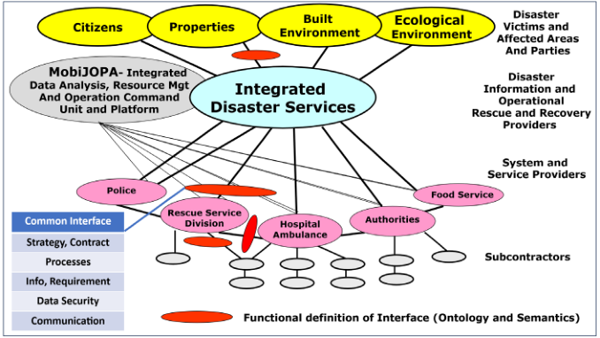
Satellite Data Supporting Situational Awareness and Management 639 response and management in the era of climate change require seamless coordination across numerous agencies, systems, and stakeholders. A shared understanding of the situation is critical as responders from different organizations (e.g., fire, medical, police, military) must work in concert under high pressure. The common ontological definition is important for various stakeholders and expert groups to understand disasters during their different stages for controlling and managing salvation and recovery (Salminen et al., 2025/1). The increasing frequency and intensity of natural disasters such as floods call for innovative, coordinated, and intelligent response strategies. Integrating semantic infrastructures into disaster management systems offers a promising pathway to improving interoperability, user inclusion, and service efficiency. A networked service environment involves multiple stakeholders, heterogeneous data sources, and critical, time-sensitive decision processes (Figure 1). A semantic infrastructure is underpinned by a common ontology, to ensure that data from various sources could be meaningfully combined and used in service processes.
Figure 1: Common interface management for network operations by layered semantic definition.
A shared understanding of the situation is critical as responders from different organizations (e.g., fire, medical, police, military) must operate under high pressure. Semantic interoperability works in practice between different organizations by creating a common language and meaning structure that enables information to be exchanged and understood without misunderstanding. This is achieved through a common ontology that defines key concepts unambiguously.
Satellite data supports situational awareness, and it is crucial to utilize satellite data and ontology platforms in disaster situation management. This article introduces analysis of the utilization of ICEYE’s SAR satellite technology and semantic ontology platforms in creating a situational picture and situation management of natural disasters, especially major floods. The focus is on an integrated hybrid model applied at the situation management
640 Salminen and Pyykkönen site, which combines the SITAW situational picture levels (observation, understanding, anticipation) and the OODA decision-making cycle (Observe, Orient, Decide, Act) as a continuous iterative process. The article highlights that the challenge of traditional optical satellites is their weather dependence, which often makes them unusable in storms and heavy rains. This problem is solved by ICEYE’s SAR radar technology, which is able to penetrate clouds, smoke and darkness, producing weather-independent and real-time geographic information (GIS) from the incident area. Satellite- based SAR data is important to integrate regional sensor data (e.g. ground-based sensor fusion data, drone data and weather sensor data).
The intelligent solution, MobiJOPA™ of start-up enterprise Husqtec Corp, served as use case environment for situation management. The received satellite data is directed to the semantic infrastructure of the MobiJOPA™ unit, where rule-based artificial intelligence and a common ontology model fuse it with, among other things, terrain elevation models (DEMs) and existing infrastructure information. The system harmonizes data from different sources into an unambiguous situational picture tied to the emergency workers’ own language, which breaks down information silos and effectively prevents misunderstandings between different authorities.
THEORETICAL FRAMEWORK ‘Situational awareness means understanding what is happening around us and is recognized as a critical foundation for successful decision-making across a broad range of situations and leads to situation management’ (Stanton et al., 2009). ‘Situational awareness is presented as a predominant concern in system operation, based on a descriptive view of decision making’ (Endsley, 1995). ‘Situational awareness is defined as the perception of entities in the environment, comprehension of their meaning, and projection of their status in the near future’ (Munir et al., 2022). ‘Lundberg (2015) describes the situation awareness system and process dependencies on system awareness states and also describes the situation system components as mediators and catalysts for the situation.’ ‘The integration of SAR data with hydraulic modelling and Geographic Information Systems (GIS) provided a clear picture of the flood extent and significantly improved the accuracy of flood risk assessments and supported effective flood response strategies. (Surer, 2024)’ ‘Babitski et al. (2009) demonstrated that an ontology-based integration of sensor data in a flood scenario significantly enhanced situation understanding for responders, improving both interpretation of data and coordination among teams.’ ‘Similarly, Elmhadhbi and Karray (2021) proposed a semantic framework for disaster management that enabled a holistic understanding of crisis information, resulting in better stakeholder coordination and decision-making in flood response case studies.’ ‘OODA- Loop is an efficient decision-making process (Observe, Orient, Decide, and Act)’ (McKay et al., 2023). ‘Disaster management ontology definition is the starting point in process harmonization for aligning how different agencies’ processes intersect. The common ontology serves as the backbone for semantic structure and information harmonization (Salminen et al., 2025/2). The individuals working in situation management unit have various type of
Satellite Data Supporting Situational Awareness and Management 641 knowledge and shape of understanding. Building interoperability between stakeholders requires understanding the real-world semantics, linking formal data to meanings that make sense to humans in their roles. In other words, the ontology must be grounded in the language and practice of emergency responders (Salminen et al., 2026). Open-access earth observation and satellite data volumes have grown exponentially. Through use of this data, geohazard remote sensing scientists’ abilities to impact policy and reduce societal vulnerability to geohazards has become increasingly tangible. (Payne et al., 2025) Disaster Risk Reduction (DRR) is understood to mean the development and application of policies, strategies, and practices to reduce vulnerabilities and disaster risks throughout society (Twigg, 2015). The relatively recent Disaster Studies Manifesto: Power, Prestige and Forgotten Values (Gaillard et al., 2019) provides a new academic “opening” (Khan et al., 2022) to address power imbalances and inequity in DRR practices. ‘Ontology can represent an entire knowledge base in user-friendly ontology graphs. The responsibility matrix of different disaster management phases and assistance of funds to disaster effect people suggested by the The National Disaster Management Authority, NDMP, through its various guidelines has been implemented using Semantic Web Rule Language (SWRL). The inclusion of SWRL rules for implementing the assistance is the actual heart and soul of our decision support system.’ (Shukla et al., 2023) ‘Through detailed analysis, it was found that SAR data provides an immediate and precise visualization of flood extents, offering significant improvements over traditional flood monitoring methods. This integration enhances the ability to quickly identify flood-prone areas and supports the development of effective flood response strategies. Specifically, the combination of SAR data and hydraulic models has improved the accuracy of flood risk assessments and enabled more efficient emergency response planning.’ The use of artificial intelligence and machine learning has been a game changer, helping emergency teams understand situations faster and make quick decisions when needed (Sun et al., 2020).
RESEARCH QUESTIONS AND RESEARCH APPROACH This research examines the formalization of common ontology and semantics aspects during nature disaster identification and management. Understanding the nature of the event and situation awareness during a natural disaster is crucial for survival and recovery. Management of the disaster event requires seamless coordination across numerous agencies, systems, and stakeholders. A shared understanding of the situation is critical as responders from different organizations (e.g., fire, medical, police, military) must operate under high pressure.
During the research on the disaster event ontology, the following research questions have been answered:
1. What advantages does ICEYE’s SAR radar technology offer in maintaining continuous situational awareness compared to traditional optical satellites in extreme weather conditions?
2. How does the integration of SITAW and OODA as a hybrid model and part of semantic infrastructure enhance situational management during flood disasters? 3. How does the combination of radar data and terrain elevation models (DEM) speed up post-flood damage analysis and compensation processes at the building level? 4. How is real-time geographic information system (GIS) satellite data utilized in practice in optimizing rescue logistics, such as the selection of evacuation routes and shelters? 5. How to integrate regional sensor data (e.g. ground-based sensor fusion data, drone data and weather sensor data) with satellite-based SAR data by AI -agent technology?
Data for the creation of the analysis has been continuously collected from regional training sessions, where participants practiced in virtual disaster event scenarios. This research has an action-based approach and uses a method based on grounded theory (Glaser, A. Strauss, 1999). This research has been executed by constructive, conceptual, and analytical way. Flood disaster has been as the use case. This study introduces an ontology platform for event analysis and management. Data for concept creation has been continuously collected from the innovation and development phase of the case study start-up company Husqtec Corp. The situation management unit MobiJOPA™ is introduced on which the situation analysis, resource control and operation command is executed. This action-type research approach may be seen as a type of applied science.
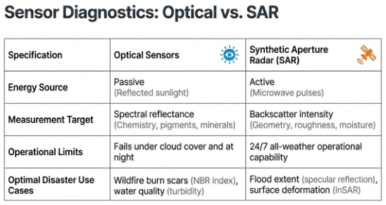
SATELLITE DATA SUPPORTING DISASTER MANAGEMENT It is critical to understand the difference of SAR (Synthetic Aperture Radar)- satellites and optical satellites in the use of disaster awareness and management (Figure 2). SAR technology provides several critical advantages over traditional optical satellites for maintaining situational awareness, particularly during natural disasters. Unlike traditional optical satellites, which are dependent on clear weather and often rendered unusable by storms and heavy rains, SAR technology is weather-independent. SAR radar is capable of penetrating clouds, smoke, and darkness, ensuring a continuous stream of data regardless of environmental conditions. The technology produces real-time geographic information (GIS) from incident areas at frequent intervals. This continuous data flow allows for high-precision monitoring, such as building-specific water-depth measurements taken just hours after a flood peak. By overcoming the visibility limitations of optical sensors, SAR shifts disaster management from reactive guesswork to data- driven, proactive action, which significantly improves the efficiency of rescue efforts and resource prioritization.
Figure 2: Evaluation of the functionality of optical- and SAR- satellites.
ICEYE’s own operational Flood Insights publications (ICEYE-report, 2025) and data models demonstrate that microwave-based SAR- technology is effectively immune to adverse weather conditions. Because microwaves penetrate clouds, smoke, and heavy rain without interference, the technology enables persistent monitoring and the creation of an uninterrupted situational picture regardless of the time of day. From the perspective of the Situation Picture Maintainer, a traditional optical satellite is unreliable in a crisis situation, as it is weather-dependent (gets “blinded” by storms, heavy rain, smoke, and darkness). During crises, the Observe phase of the OODA loop must not be broken. ICEYE’s SAR radar technology penetrates clouds, smoke, and darkness. It provides weather-independent, real-time spatial data (GIS) from the incident area at intervals of up to six hours. This guarantees the MobiJOPA unit an uninterrupted and delay-free observation capability, which is a lifeline in time-critical situational management.
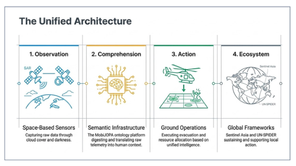
INTEGRATION OF SATELLITE DATA AND REGIONAL DATA The use of semantic infrastructure in situational awareness (such as in SITAW systems) offers several advantages, as it enables meaningful linking and analysis of information. A unified architecture is needed for disaster prediction and management (Figure 3).
Figure 3: Unified architecture for disaster prediction and management.
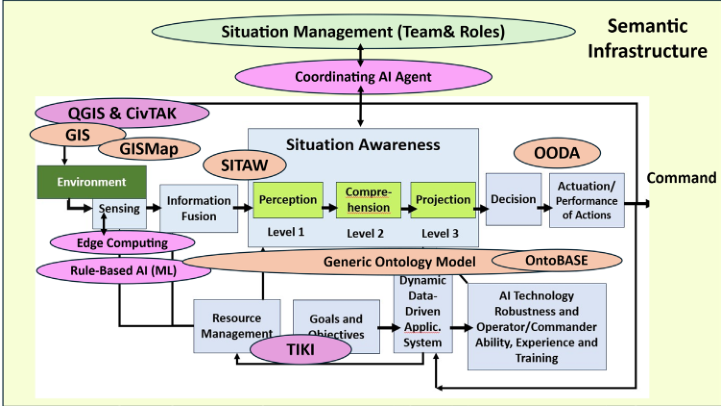
644 Salminen and Pyykkönen The system uses event and situational ontologies to integrate and harmonize vast, diverse datasets into a standardized, machine-readable format. Event and situation ontologies must be integrated on the data and information routing platform (Figure 4), a domain-specific ontology model (Salminen et al., 2026). This framework helps to clearly distribute responsibilities and translate data for different authorities during various phases of a disaster, perfectly mirroring the operational goals of MobiJOPA’s SITAW/OODA hybrid model.
Figure 4: Integration architecture related to situation awareness and management.
The recommended practices of the UN’s UN-SPIDER program (United Nations Platform for Space-based Information for Disaster Management and Emergency Response) heavily emphasize the fusion of SAR data with high-resolution digital elevation models (DEM).’ (UN-Spider. 2026).
This methodology enables highly accurate water-level measurements and damage assessments even during completely overcast weather. ICEYE has actively commercialized this model, where radar data is fused with auxiliary information (like DEMs) to extract building-level analytical data. This specifically enables automated, parametric insurance claims and significantly accelerates post-disaster reconstruction efforts.
In a fully realized operational environment, this macro-level data obtained from satellites is fused with regional micro-data. For example, modern search and rescue operations increasingly utilize long-range fixed-wing drones (UAVs) that collect thermal camera data from below the cloud cover. Integration of ICEYE SAR satellite data and semantic AI infrastructure in flood disaster management ICEYE’s SAR radar technology offers advantages in maintaining a continuous situational awareness compared to traditional optical satellites in extreme weather conditions. Traditional optical satellite is unreliable in a crisis, as it is weather-dependent (gets “blinded” by storms, heavy rain,
Satellite Data Supporting Situational Awareness and Management 645 smoke, and darkness). During crises, the Observe phase of the OODA loop must not be broken.
The integration of SITAW and OODA as a hybrid model and part of semantic infrastructure enhances situational management during flood disasters, solving the biggest problem in field operations: information silos and misunderstandings between different authorities (police, rescue, defense forces).
In MobiJOPA’s semantic infrastructure, the SITAW levels (observation, understanding, anticipation) and the OODA loop operate as an iterative engine. When AI and a common ontology platform harmonize data from different sources, it is automatically translated into the “native language” of the field operators. This radically speeds up the Orient and Decide phases of the OODA loop. Operations shift from reactive guessing to proactive, data- driven management.
The combination of radar data and terrain elevation models (DEM) speeds up post-flood damage analysis and compensation processes at the building level. From the perspective of the Resource Coordinator and post- disaster recovery, speed is critical. When SAR radar data is fused with terrain elevation models (DEM) using MobiJOPA’s AI, we get accurate, building- specific water depth measurements just hours after the flood peak.
This absolute data eliminates the slowness of human estimation and enables automatic (parametric) insurance claims and compensations. From a societal standpoint, this accelerates the start of reconstruction and immediately frees up operational resources for subsequent missions.
Real-time geographic information system (GIS) satellite data is utilized in practice in optimizing rescue logistics, such as the selection of evacuation routes and shelters. The anticipation phase of the SITAW model relies directly on this capability. Real-time GIS data shows the Situation Center which parts of the infrastructure (roads, bridges) are still usable, and which are underwater. In practice, this means we can route Operator Teams (rescue vehicles, drones) along safe paths and prioritize resources to the most acute threat areas. The data prevents rescue units from driving into a trap and ensures civilians are directed to evacuation centers where supply routes are confirmed open by the radar data. In disaster crisis situations it is a massive technological need for solutions that prevent cognitive overload. The seamless hybrid intelligence between humans (Situation Commander) and AI agents is heavily emphasized.
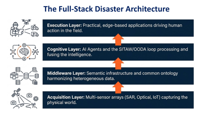
THE FULL-STACK DISASTER ARCHITECTURE It is important to create a full-stack architecture for disaster situational awareness and management. It is designed as a multi-layered ecosystem that transforms heterogeneous data from satellites and online sources into actionable intelligence. This architecture utilizes semantic infrastructure as its backbone to ensure that disparate information systems can communicate without misunderstanding.
646 Salminen and Pyykkönen It is formed from four layers (Figure 5): backend data acquisition layer, process and control integration and semantic layer, information flow unifying API- Interface layer and frontend data visualizing and application layer. It is a multi- layered ecosystem transforming satellite data acquisition into regional edge execution.
Data acquisition layer manages the ingestion of raw data from diverse sources: satellite data, regional online data from an integrated IoT- sensor network and crowdsourced data consisting of real-time citizen reports on casualties and infrastructure damages.
Process and control integration and semantic layer is middleware implemented in data collecting central unit like MobiJOPA™, which serves as the “brain” of the disaster management system. It is functioning by using the Common Ontology Model, which acts as a shared terminology that maps different terms (e.g., “paramedic team” vs. “medical unit”) to a single unambiguous entity. Rule-based AI and coordinating AI agents fuse satellite SAR data with terrain models (DEM) and infrastructure information. These agents can proactively identify threats, such as predicting waterborne diseases following a flood alert. The hybrid SITAW-OODA model integrates the three levels of Situational Awareness (SITAW)—observation, understanding, and anticipation—with the OODA loop (Observe, Orient, Decide, Act) to support a continuous, iterative decision-making cycle.
API- Interface layer unifies information and data flow through interface architecture, which standardizes how information flows between various stakeholders, agencies, and systems (Figure 1). It consists of four internal functional layers: Strategy, Process, Information/Data, Data Ownerwership/ Security and Communication layer (Salminen, 2026). The strategy layer manages high-level agreements and mutual aid policies between municipalities or international bodies. Process Layer standardizes workflows and emergency response protocols (e.g., Incident Command System) to prevent conflicting orders. Information layer encodes the disaster ontology using
Satellite Data Supporting Situational Awareness and Management 647 standards like OWL/RDF, allowing disparate IT systems to exchange data with unambiguous meaning. Data Ownership/Security Layer implements authentication and encryption, ensuring sensitive personal data is only visible to authorized roles (e.g., medical teams). Finally, the communication layer provides technical connectivity using protocols like the Common Alerting Protocol for dissemination of warnings.
The frontend data visualization and application layer provides user-specific views of the disaster zone through geographical information system (GIS)- platforms. They share value-added satellite products and thematic maps with authorized responders and the public (Sürer, 2024). Mobile GIS and Command Solutions like CivTAK and QGIS allow field workers to receive location-bound updates and transmit ground-based situational information back to the command unit. Reporting Systems like TIKI facilitate information sharing and reporting across different operational organizations.
This full-stack approach shifts disaster management from reactive “guesswork” to data-driven, proactive action, enabling rapid resource prioritization and the planning of safe evacuation routes.
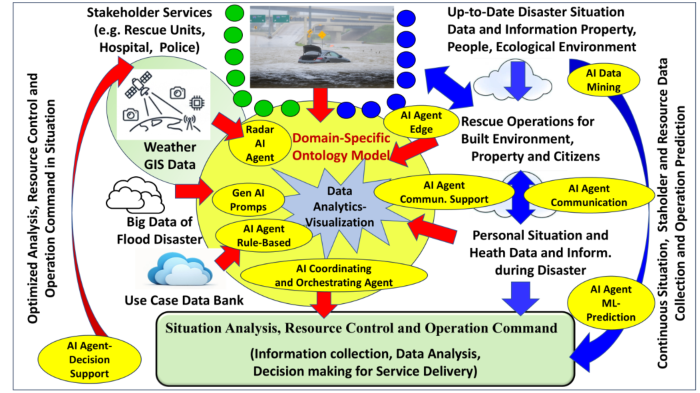
AI- AGENTS INTEGRATING HUMAN-IN-THE-LOOP Integration of regional sensor data (e.g. ground-based sensor fusion data, drone data and weather sensor data) to satellite-based SAR data by AI-agent technology is the technological “Center of Gravity” of the MobiJOPA™ unit. Raw data from various sources (drones, ground sensors, weather stations, and SAR satellites) is routed into MobiJOPA™’s semantic infrastructure. Here, rule-based AI (AI agents) fuses this local micro-level data with the broader satellite data and existing infrastructure information. The agents act as virtual radiomen and data analysts, filtering out the noise and producing a single, unambiguous “Single Source of Truth” situational picture for the Situation Commander to support rapid decision-making.
To effectively use AI in emergencies, trust is crucial. Responders must trust the system’s recommendations, and the public must trust the information they receive. Building trust requires that AI systems demonstrate reliability and that humans remain in the loop for critical decisions. Human oversight is key (Figure 6): AI should support, not replace, human decision-makers (Salminen et al., 2025/1).
AI agents use soil moisture and rainfall data within a semantic infrastructure to transform raw sensor readings into proactive, actionable intelligence during a disaster. By operating on a common ontology model, these agents move beyond simple data monitoring to complex reasoning and automated coordination. The integration of regional sensor data, including ground- based fusion data, drone data, and weather sensor data, with satellite-based SAR data is achieved through a semantic infrastructure driven by rule-based artificial intelligence. In the practical use case of the MobiJOPA™ system, all incoming data streams, including high-frequency SAR satellite data and regional sensor inputs, are directed into a centralized semantic infrastructure.
Figure 6: The use of AI and AI agents in situation awareness and management.
To ensure that disparate data types (like radar imagery, terrain models, and weather readings) can “talk” to one another, the system utilizes a common ontology model. This model provides a shared framework that defines the relationships between different data points. Rule-based artificial intelligence is then used to fuse the SAR data with regional sensors, terrain elevation models (DEMs), and existing infrastructure information. This AI-driven fusion transforms raw, multi-source data into a cohesive and actionable format. The system harmonizes these varied sources into a single, unambiguous situational picture. A critical part of this integration is that the resulting picture is tied to the emergency workers’ own language, which helps break down information silos and prevents misunderstandings between different agencies like the police, fire, and medical responders. This integrated data feeds into a hybrid model that combines SITAW situational picture levels (observation, understanding, anticipation) with the OODA decision-making cycle. This allows the AI-supported infrastructure to not just display data, but to support a continuous, iterative process of understanding and acting upon the disaster event.
The tactical role of AI agents is to seamlessly combine these distinct data vectors (macro-level satellite imagery from the sky and micro-level sensor data close to the ground) into a single, unambiguous “Single Source of Truth.”
CONCLUSION
Flood disaster management requires continuous monitoring, contextual understanding, pattern recognition, and coordinated action. Event analytics transforms raw data into life-saving decisions.
This article introduces an integrated disaster situation management system embedded by a domain-specific ontology model. The system environment for the use case is the MobiJOPA™ system developed by Husqtec Corp., a mobile and modular management unit designed for understanding disaster
Satellite Data Supporting Situational Awareness and Management 649 situations and resource allocation and management. That generates a continuous and adaptive decision loop following the OODA model. That creates an environment for cross-system semantic understanding, ensuring data consistency. The system creates opportunities for rapid reallocation of resources as conditions change and enables operational command and long-term learning. Modular and extensible architecture is adaptable to new threat types (e.g., pandemics, natural disasters).
The article introduces the analysis results of SAR-Radar technology compared to optical technology in flood disaster management. Seamless interaction of radar and semantic modeling speeds up critical decision making in disaster situations.
Semantic interoperability enabled by a common ontology and robust system architecture provides shared situational awareness and efficient coordination in disaster management. It reduces information. The adaptive training of stakeholder experts and participants involved becomes an essential continuity for refining the ontology model through practice. The article shows that the seamless interaction of radar data and semantic modeling significantly speeds up critical decision-making. It enables the planning of safe evacuation routes, rapid prioritization of resources to threat areas, and accurate building-specific water depth measurements just hours after the flood peak. The use of technology shifts crisis management from guesswork and reactivity to data-driven, proactive action, which not only improves the efficiency of rescue efforts but also speeds up reconstruction by enabling automatic parametric insurance claims.
REFERENCES
Babitski, G., Bergweiler, S., Trinh, T., Atkinson, M., Simonis, I. (2009). Ontology- Based Integration of Sensor Data for Disaster Management. Journal of Intelligent Information Systems, 33 (3), 233–253. Elmhadhbi, L., Karray, M. H. (2021). A Semantic Framework for Disaster
Management: Towards a Holistic Understanding of Crisis Scenarios. Computers in Industry, 128, 03432. Gaillard, J. C., Alexander, B., Becker, B., Blanchard, K., Bosher, L., Briones, F., Cadag, J. R., Chmutina, K., Coetzee, C., Forino, G., Gomez, C., Jigyasu, R., Kelman, I., Le De, L., Marchezini, V., Mercer, J., Molina, F. G., Raju, E., Sagala, S., Saito, Y., Towers, B., van Niekerk, D., von Meding, J., and Ziqiang, H.(2019) Power, Prestige & Forgotten Values: A Disaster Studies Manifesto, https://www.ipetitions. com/petition/1270 power-prestige-forgotten-values-a-disaster. McKay. B., McKay K. (2023) The Tao of Boyd: How to Master the OODA Loop.
Behavior, Character, Featured November 6, 2020. Last updated: July 1, 2023 Endsley, M., (1995) Towards a Theory of Situation Awareness. Human Factors.
The Journal of the Human Factors and Ergonomics, March 1995, 37(1), 32–64 DOI: 10.1518/001872095779049543 Glaser, B., Strauss, A. (1999) Discovery of Grounded Theory: Strategies for Qualitative Research. Aldine Transactions. ICEYE report (2026) Satellite-driven Flood Insights. https://www.iceye.com/lp/
650 Salminen and Pyykkönen Khan, J., Ren, X., Hussain, M. A., and Jan, M. Q.: Monitoring Land Subsidence
Using PS-InSAR Technique in Rawalpindi and Islamabad, Pakistan, Remote Sensing, 14, 3722, https://doi.org/10.3390/rs14153722, 2022. Lundberg, J. (2015) Situation awareness systems, states and processes: A holistic framework, Theoretical Issues in Ergonomics Science, 16:5, 447–473, DOI: 10.1080/1463922X.2015.1008601 Munir, A., Aved, A., Blasch, E. (2022) Situational Awareness: Techniques, Challenges,
and Prospects. AI, January 2022, MDPI., 3, 55–77. DOI: 10.3390/ ai3010005. Payne, J. A. and Donovan, K. (2025) The ethics of using satellite data to monitor and publish research on geohazards in regions of political complexity, EGUsphere [preprint], https://doi.org/10.5194/egusphere-2025-1836, 2025. Salminen, V., Pyykkönen, M., Salminen, C. (2025/1) Human aspects in Situation
Analysis, Resource Control, and Operation Command. Human Factors, Business Management and Society, Book, Vol. 176, 2025, 95–106 DOI: 10.54941/ ahfe1006307. Salminen V, Pyykkönen, M., Saarinen A. (2025/2) Disaster Situation Management by Using Common Ontology and Semantic Infrastructure. AHFE International Open-Source Publishing. Human Systems Engineering and Design (IHSED2025), Vol. 198, 2025, 1–17 https://doi.org/10.54941/ahfe1006756, DOI: 10.54941/ ahfe1006756. Salminen, V., Pyykkönen M., Saarinen, A., Ylirotu, N. (2026) Integrated Disaster
Situation Management System With Domain-Specific Ontology Model Intelligent Human Systems Integration (IHSI), Vol. 200, 2026, 1–11. https://doi.org/10.54941/ AHFE-Paper-0118 Shukla, D., Azad, H., Abhishek, K.,Shitharth, S. (2023) Disaster management ontology- an ontological approach to disaster management automation. Nature Scientific Reports (2023) 13:8091. https://doi.org/10.1038/s41598-023-34874-6 Sun, W., Bocchini, P., & Davison, B. D. (2020). Applications of artificial intelligence
for disaster management. Natural Hazards, 103(3), 2631–2689. Sürer, S. (2024) From Space to Safety: Flood Mapping with Sentinel-1 SAR Data for Enhancing Flood Risk Management in Ljungby Municipality. https://lup.lub. lu.se/student-papers/record/9158441 Stanton, N.A., P.M. Salmon, G.H. Walker, and D.P. Jenkins. (2009) Genotype
and Phenotype Schemata and Their Role in Distributed Situation Awareness in Collaborative Systems. Theoretical Issues in Ergonomics Science 10 (1): 4368. https://doi.org/10.1080/14639220802045199 UN-SPIDER (2026) United Nations Platform for Space-based Information for Disaster Management and Emergency Response. https://www.unoosa.org/oosa/ en/ourwork/un-spider/