Ioannis Symeonidis, Nikolaos Angelopoulos, Maria Gkemou, Evangelos Bekiaris (2026). Validation of a UAV-Based Digital Twin for VRU Safety in Urban Environments with Simulations. In: Human Interaction and Emerging Technologies (IHIET 2026). AHFE Open Access, vol. 236, pp. 538–545. https://doi.org/10.54941/ahfe1008129
Vulnerable Road Users (VRUs), including pedestrians, cyclists and micromobility users, remain exposed to high risk in urban traffic locations where buildings, parked vehicles or infrastructure create occlusions. This paper validates a UAV-based digital twin for VRU safety in urban environments using a combined field-test and simulation-supported methodology. The digital twin is designed as a temporary and rapidly deployable perception extension for connected and automated vehicles. The proposed Physical, Digital and Communication infrastructure combines a UAV-mounted camera, edge-based artificial intelligence, a roadside unit and the vehicle onboard unit. The UAV monitors a region of interest and streams video to the edge node, where VRUs are detected, tracked and projected into world coordinates using RTK-enabled georeferencing and camera pose information. Vehicle states are received through Cooperative Awareness Messages, while the edge node uses synchronized state estimation and short-horizon trajectory prediction to assess possible path conflicts and time-to-collision. When a relevant risk is identified, warning information is inserted into the vehicle perception loop through standardized V2X messages. The validation was performed through pedestrian-crossing trials at the EMT Carabanchel bus depot in Madrid and through openPASS simulations of the occluded turning geometry. The results show that the UAV-based digital twin can detect occluded pedestrians before they are available to onboard sensors and can support more progressive vehicle deceleration. The simulation comparison confirms that, in the occluded turning scenario, the digital-twin warning provides an operational advantage by enabling a more anticipatory and interpretable vehicle response than vehicle-only AEB. Future research will perform a large number of simulations to vary and explore more scenarios.
Urban mobility automation is constrained not only by the performance of onboard perception sensors, but also by the geometry of the environment. A connected and automated vehicle may have a reliable camera, lidar or
Validation of a UAV-Based Digital Twin for VRU Safety 539 radar suite and still fail to observe a pedestrian who is hidden by a building corner, a bus, a parked vehicle or other infrastructure. These situations are particularly critical for VRUs, because the vehicle may receive the necessary visual information only after the available reaction time has already become very limited. For this reason, validation of external perception support is required before such systems can be considered useful for urban safety applications (Tiwari, 2025).
Collective perception addresses this limitation by sharing information about objects detected by other agents or infrastructure. Instead of relying only on what the vehicle can directly sense, a cooperative system can extend the vehicle perception horizon by adding observations from roadside sensors, other vehicles or aerial sensors. This principle is reflected in current European C-ITS services and message sets, including Cooperative Awareness Messages (CAMs), Collective Perception Messages (CPMs) and Decentralized Environmental Notification Messages (DENMs) (ETSI, 2019; ETSI, 2023). Reviews of collective perception for automated driving underline its value for reducing blind spots and increasing shared scene awareness (Figueiredo et al., 2022; Schiegg et al., 2020).
This paper focuses on the validation of an ad hoc UAV-based digital twin for VRU safety. The term ad hoc is important: the system is not intended as a permanent smart-intersection installation, but as a flexible and temporary sensing layer that can be deployed at depots, campuses, logistics hubs, work zones, event areas or urban sites where VRU density temporarily increases. The digital twin is a continuously updated representation of the local traffic scene that combines aerial perception of VRUs, vehicle state information, risk prediction and V2X warning dissemination. The validation question addressed in the paper is whether this digital representation can give the vehicle useful risk information before a hidden VRU becomes visible from the vehicle perspective.
The contribution of the work is threefold. First, it defines the UAV-based digital twin and the Physical, Digital and Communication infrastructure used to generate georeferenced VRU state estimates and risk information. Second, it validates the integrated system in field trials involving real pedestrian- crossing scenarios, an automated vehicle and an occluding urban structure. Third, it complements the field validation with openPASS simulations of the occluded turning geometry, allowing the digital-twin warning response to be compared with a vehicle-only AEB response under controlled and repeatable conditions.
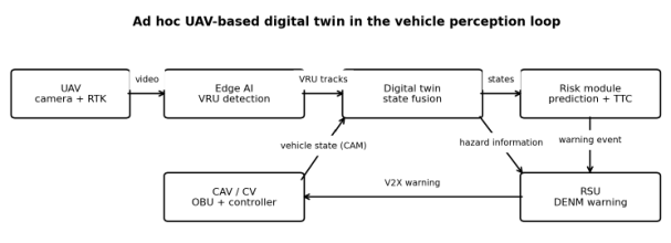
SYSTEM CONCEPT AND VALIDATION METHODOLOGY The proposed system is structured as a Physical, Digital and Communication infrastructure (Symeonidis et al., 2025). The validation methodology combines two complementary layers. The first layer is an integrated field test, used to verify that the UAV, edge perception, georeferencing, risk assessment and V2X warning chain operate together in a realistic urban-like environment. The second layer is an openPASS simulation, used to reproduce the critical occluded turning geometry and compare alternative vehicle response mechanisms under repeatable conditions. Figure 1 summarizes
the information flow between the physical, digital and communication components.
Figure 1: Ad hoc UAV-based digital twin architecture and information flow.
The UAV hovers over a selected region of interest and provides a top-down camera view of the pedestrian crossing or conflict area. The aerial viewpoint is valuable because it can eliminate occlusions that exist from the vehicle perspective. Video is processed at the edge node by a deep-learning object detector that identifies VRUs and produces bounding boxes for each detected person. The detections are associated over time to maintain a consistent track identifier for each VRU.
Detected image coordinates are transformed into world coordinates using the RTK-enabled UAV position, the camera pose and a calibrated ground- plane model. The resulting VRU state contains position, speed and heading. In the field trials, pedestrian localization accuracy was better than 1 m when compared with ground-truth reference points. This level of localization is sufficient for the studied low-speed depot scenarios and for early risk screening in a C-ITS warning pipeline.
In parallel, the approaching vehicle transmits its own kinematic state through CAMs. The edge node uses the VRU tracks and the vehicle state to maintain a synchronized digital representation of the local scene. An Unscented Kalman Filter with a Constant Turn Rate and Velocity motion model is used to smooth the agent states and align them to a common time base. This filtering step reduces the effect of measurement noise and provides a consistent input for trajectory prediction.
The risk module predicts short-horizon trajectories for the VRU and the vehicle and tests for path conflicts. When a potential conflict is detected, time-to-collision and conflict probability are estimated. If the risk threshold is exceeded, the system generates a warning event that is transmitted to the vehicle through DENM-based V2X signaling. The validation therefore examines the complete chain from aerial observation to digital-twin state update, risk estimation and vehicle behavior, rather than evaluating the perception module alone.
FIELD-TEST VALIDATION DESIGN The field-test validation was carried out at the EMT Carabanchel bus depot in Madrid, Spain. This site was selected because it provides a semi-controlled but realistic urban environment with buildings, parked buses, internal roads
Validation of a UAV-Based Digital Twin for VRU Safety 541 and pedestrian crossings. The UAV used in the trials was a DJI Mavic 3M with RTK support. The connected and automated vehicle was a Renault Twizy research platform equipped with an onboard unit and baseline sensors. A roadside unit, an edge-computing station and the RTK infrastructure were installed close to the crossing area.
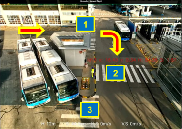
Three pedestrian-crossing setups were used to validate the system under different geometric conditions. Setup 1 represented a straight vehicle approach to a pedestrian crossing. Setup 2 represented a turning vehicle path where the building created a stronger occlusion and was therefore selected for simulation-supported validation. Setup 3 represented a geometry in which the pedestrian and vehicle motions were not expected to create a collision, enabling a check of conservative warning behavior. A safety operator was inside the vehicle during all tests, and the vehicle speed was kept low in order to maintain safe trial conditions. Figure 2 shows the field-test crossing arrangements.
Figure 2: Field-test pedestrian-crossing setups at the EMT Carabanchel bus depot.
FIELD-TEST VALIDATION RESULTS The field trials confirmed that the UAV-based perception module detected the pedestrian when the person entered the monitored region of interest, including cases where the pedestrian was still hidden from the vehicle perspective. In the controlled single-pedestrian trials, the tracker maintained consistent pedestrian identities and did not miss the crossing pedestrian. Early false positives observed during development were reduced through detector tuning and filtering of nonS-moving detections.
The key validation outcome was the effect of the digital-twin warning on vehicle behavior. With the UAV-based digital twin enabled, the vehicle received risk information before direct onboard perception became sufficient and initiated a smoother reduction in speed. Without the external perception support, the response depended mainly on the onboard AEB logic, which reacts when the pedestrian becomes available to the vehicle sensors. This difference is especially important in geometries where an occluding structure hides the crossing until the vehicle is close to the conflict area.
The field-test results also supported the selection of Setup 2 for simulation. Setup 1 and Setup 2 both produced relevant collision-risk cases, but Setup
2 was more closely aligned with the paper title because it combined urban occlusion, vehicle turning and the need for simulation-supported validation. Setup 3 was useful for checking conservative behavior, because the pedestrian was present but not on a strong collision path. In a few cases, the system produced low-risk warnings in this non-conflict setup. This is an acceptable safety-biased behavior for an early prototype, but it also shows the need to refine context-aware pedestrian intent prediction before large-scale deployment.
SIMULATION-SUPPORTED VALIDATION USING OPENPASS OpenPASS (open Platform for Assessment of Safety Systems) is an open- source, scenario-based traffic simulation framework developed under the Eclipse Foundation for the assessment of advanced driver assistance systems and automated-driving functions (Dobberstein et al., 2017). Its modular structure and deterministic scenario execution support reproducible comparison of alternative sensing, warning and braking configurations. In this work, openPASS was used as a simulation-supported validation layer rather than as a replacement for the field tests. The objective was to test whether the behavioral effect observed in the occluded field-test geometry could be reproduced and interpreted under controlled simulation conditions. The simulated ego vehicle approached the crossing at 5.5 m/s. Two variants were compared: a camera/RSU warning variant, representing the UAV-based digital-twin input through V2X, and a vehicle-only AEB variant, representing a response triggered by the onboard system.
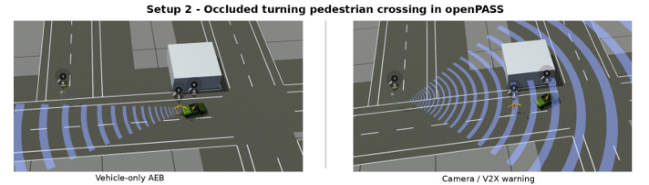
Figure 3 shows the openPASS reproduction of the occluded turning crossing setup. The scenario preserves the same functional roles as the field trials: an ego vehicle, an occluding object/building, a pedestrian and an infrastructure warning source. This case is the most relevant simulation case for the paper because it stresses the value of external perception in an urban turning geometry where the vehicle-only sensing chain is geometrically disadvantaged.
Figure 3: OpenPASS reproduction of the occluded turning pedestrian-crossing setup.Table 1: Summary of openPASS behavioral comparison for Setup 2.
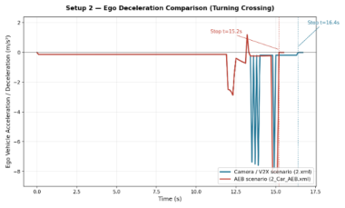
Validation of a UAV-Based Digital Twin for VRU Safety 543 The openPASS comparison for Setup 2 validates the relevance of the UAV- based digital twin in the retained occluded turning case. The AEB variant reaches a full stop earlier in time (15.20 s vs. 16.40 s), but with a slightly stronger peak deceleration (-8.04 m/s2 vs. −7.78 m/s2) and with the stop occurring much closer to the conflict point. The V2X-warning variant therefore represents a more progressive response initiated from external perception rather than from late onboard detection.
Figure 4 visualizes the deceleration traces for Setup 2. The differentiated braking profiles show that the simulation is not only a reproduction of the field geometry; it provides a validation tool for isolating the behavioral contribution of the digital-twin warning in the occluded urban crossing scenario.
Figure 4: OpenPASS deceleration comparison for the occluded turning crossing (Setup 2).
DISCUSSION
The combined field-test and simulation results support the title claim that a UAV-based digital twin can be validated for VRU safety in urban environments using both real-world trials and simulation. The field tests demonstrate that the system can detect a hidden pedestrian, georeference the detection and produce a risk-aware warning. The openPASS comparison clarifies the expected behavioral benefit in the retained occluded-turning scenario: the external perception layer provides context that can support a smoother and more anticipatory response than a vehicle-only AEB reaction triggered from later onboard detection.
This validation perspective is important for operational design domain expansion. A CAV that must rely exclusively on its onboard sensors may treat an occluded crossing as a high-uncertainty situation or may react only after a pedestrian appears in its field of view. By contrast, the UAV-based digital twin can make the hidden pedestrian part of the vehicle scene model. The vehicle does not need to know that the observation comes from a UAV; it needs a trusted object/risk representation that can be integrated into the perception and planning loop.
The approach also introduces practical trade-offs. A safety-focused predictor may produce occasional conservative warnings, especially when a pedestrian is near a conflict zone but does not intend to cross. Reducing these
false positives requires richer contextual prediction, including pedestrian intent, scene semantics and interaction-aware models (Mirzabagheri et al., 2025). At the same time, the system should remain conservative enough to protect VRUs, because the cost of a missed occluded pedestrian is much higher than the cost of a moderate speed reduction.
UAV deployment adds further practical constraints. Battery endurance, weather robustness, airspace rules, camera calibration and operational supervision affect the suitability of the concept for continuous use. For this reason, the most realistic near-term applications are controlled or semi- controlled areas such as depots, campuses, industrial sites, logistics hubs and temporary event zones. These environments can benefit from flexible sensing without requiring permanent infrastructure installation at every potential conflict point.
Finally, the digital twin should be understood as a decision-support representation rather than a perfect prediction of reality. Calibration and validation against observed tests reduce errors under the tested conditions, but they do not guarantee that every new control action, traffic configuration or pedestrian behavior will be predicted accurately. This is why the title explicitly combines validation with simulations: field testing verifies the integrated system in reality, while simulation supports repeatable exploration of critical cases that are difficult to reproduce many times in physical trials.
CONCLUSION
This paper presents the validation approach of a UAV-based digital twin for VRU safety in urban and urban-like environments using field tests and simulation-supported assessment. The system combines aerial perception, edge AI, georeferenced tracking, vehicle state input and C-ITS warning messages to extend the vehicle perception horizon in occluded pedestrian- crossing scenarios. Field tests at the EMT Carabanchel bus depot showed that the system can detect and localize hidden pedestrians and support smoother vehicle deceleration before onboard sensors alone are sufficient.
The openPASS simulation results provide an additional validation layer for the occluded turning crossing. In this geometry, where occlusion is influential, the external digital-twin warning supported a more progressive response compared with the vehicle-only AEB variant. These findings confirm that UAV-assisted collective perception is most useful when the vehicle is geometrically disadvantaged and when simulation can help isolate the contribution of the external perception layer.
Future work will focus on Monte Carlo simulations to systematically vary pedestrian start time, walking speed, vehicle speed, braking thresholds, perception uncertainty and trajectory-prediction uncertainty. This will enable statistical validation of collision avoidance, false warnings, time-to- collision margins and comfort-related deceleration over a broader range of operating conditions than deterministic field-test repetitions alone. Additional validation in different urban layouts and with more diverse VRU behavior will be necessary before the concept can move from prototype demonstrations to operational deployment.
ACKNOWLEDGMENT
The authors would like to thank the employees of Empresa Municipal de Transportes de Madrid for supporting and participating in the field experiments. This research was partially funded by the European Union Horizon Europe programme under Grant Agreement No. 101069717.
REFERENCES
Dobberstein, J., Bakker, J., Wang, L., Vogt, T., Düring, M., Stark, L., Gainey, J., Prahl, A., Mueller, R., & Blondelle, G. (2017) The Eclipse Working Group openPASS - an open source approach to safety impact assessment via simulation [Paper presentation]. 25th International Technical Conference on the Enhanced Safety of Vehicles (ESV), Detroit, MI, United States. ETSI (2019) Intelligent Transport Systems (ITS); Vehicular Communications; Basic
Set of Applications; Part 2: Specification of Cooperative Awareness Basic Service, EN 302 637-2 V1.4.1. European Telecommunications Standards Institute. ETSI (2023) Intelligent Transport Systems (ITS); Collective Perception Service; Release 2, TS 103 324 V2.1.1. European Telecommunications Standards Institute. Figueiredo, R., Santos, L. and Ferreira, M. (2022) Collective Perception for
Connected and Automated Driving: A Literature Review. IEEE Access, 10, pp. 118211–118233. Garlichs, T., Klingler, F., Doll, J., Sommer, C. and Dressler, F. (2020) Leveraging the Collective Perception Service for CAM Information Aggregation at Intersections. Proceedings of IEEE VTC-Fall, pp. 1–7. Mirzabagheri, A., Ahmadi, M., Zhang, N., Alirezaee, R. and Erfani, S.M. (2025)
Navigating uncertainty: Advanced techniques in pedestrian intention prediction for autonomous vehicles - A comprehensive review. Vehicles, 7(2), 57. Schiegg, F.A., Llatser, I., Bischoff, D. and Volk, G. (2020) Collective Perception: A Safety Perspective. Sensors, 21(1), 159. Symeonidis, I., Gkragkopoulos, I., Tsetsinas, I., Gkemou, M., Marcano Sandoval, M.,
Gonzalez Alarcon, L. D., Isasi De La Iglesia, L., Fernández Balaguer, S., Chacón Fernández, C. O., & Bekiaris, E. (2025). ACCAM: C-ITS collective perception from aerial views [Conference presentation]. 3rd International Conference on Electrical Engineering and Computational Science (ICELECS 2025), Herakleion, Crete, Greece. Tiwari, G. (2025) Renew global partnerships for addressing the risk to vulnerable road users and strengthening research institutions. International Journal of Injury Control and Safety Promotion. Advance online publication. Wolff, V.A. and Xhoxhi, E. (2024) Mitigating Vulnerable Road Users Occlusion Risk
via Collective Perception: An Empirical Analysis. Proceedings of IEEE Vehicular Networking Conference.
SEARCH THE AHFE DIGITAL BOOKSTORE BY ISBN
Explore the complete digital volume
Human Interaction and Emerging Technologies (IHIET 2026)
Read this individual research paper free through the original publisher, or explore the full digital proceedings book.