Letizia Artioli, Giovanni Borga, Pietro Costa (2026). Marine Protected Area (MPA) Digital Twin Framework and Its Perspectives. In: Human Factors in Architecture, Sustainable Urban Planning and Infrastructure. AHFE Open Access, vol. 229, pp. 169–179. https://doi.org/10.54941/ahfe1007965
Marine Protected Areas (MPAs) are increasingly recognised as critical infrastructures for biodiversity conservation, climate regulation, and the resilience of coastal socio-ecological systems, while also supporting emerging Blue Economy strategies. Among the ecosystems they safeguard, Posidonia oceanica meadows represent a particularly valuable and vulnerable component of the Mediterranean seascape, providing long-term carbon sequestration. This paper proposes a Digital Twin (DT) framework for the Marine Protected Area of Ischia (Regno di Nettuno), conceived as a dynamic, data-driven system to support continuous monitoring, adaptive governance, and the development of Blue Carbon initiatives. By integrating heterogeneous data streams across ecological, infrastructural, and socio-economic dimensions, the system aims to support continuous monitoring, risk assessment, and evidence-based governance.The methodology combines an analysis of data availability and accessibility with a systematic mapping of stakeholders and activities. The DT is designed as a circular data–action–feedback chain, transforming input data into descriptive and predictive outputs—such as what-if scenarios and dynamic cartographies—which are disseminated through web, mobile, and Digital Twin interfaces. These outputs inform stakeholder activities and are enacted through a set of regulatory, ecological, socio-economic, participatory, and technical actuators, generating real-world interventions and new data inputs. The proposed framework shows the MPA DT designed as a socio-technical interface that connects marine ecosystems, informed decision-making, and civic engagement, fostering more resilient and inclusive approaches to marine conservation.
Marine Protected Areas (MPAs) are increasingly recognised as critical infrastructures for biodiversity conservation, climate regulation, and the resilience of coastal socio-ecological systems, while also supporting the Blue Economy (Pauli, 2010). Among the ecosystems they safeguard, Posidonia oceanica meadows constitute one of the most ecologically significant and vulnerable components of the Mediterranean seascape, providing essential services such as shoreline stabilisation, habitat provision, water quality regulation, and long-term carbon sequestration. As part of the broader category of coastal vegetated systems, seagrass meadows are among the most efficient natural carbon sinks, with sequestration rates 30 to 50 times higher than many terrestrial ecosystems (Monnier et al., 2022). Their role is central to
170 Artioli and Borga Blue Carbon strategies, which have emerged within global climate mitigation frameworks aligned with the Paris Agreement and nature-based solutions (Herr et al., 2017 in Monnier et al., 2022). Widely distributed across marine and coastal environments seagrass meadows are highly productive (Duarte and Chiscano, 1999 in Monnier et al.,) and globally valuable ecosystems (Pillai et al., 2022), recognised since the early 1980s for their capacity to accumulate organic carbon (Smith, 1981). In the Mediterranean, Posidonia oceanica is endemic and can sequester approximately 20 tonnes of CO2 per hectare per year, while preventing the release of up to 500 tonnes into the atmosphere (Pergent, 1994 in Borga et al., 2022). Posidonia meadows are increasingly exposed to cumulative anthropogenic pressures from climate variability, coastal urbanisation, maritime traffic, anchoring, pollution, and mass tourism, while traditional monitoring approaches struggle to capture the dynamic and multi-risk variables of these complex environments (Pillai, 2022; Tzachor, 2021). The concept of Digital Twin (DT) (Grieves, 2002) has emerged as an ubiquitous (Blair, 2021) and promising paradigm for modelling complex ecological systems (Durden, 2025; DeKoning et al., 2024). DTs enable real- time synchronisation, predictive simulation, and scenario testing, supporting a shift from descriptive to anticipatory governance in marine sustainability (Tzachor, 2021). The proposal of a DT as the tool for the MPA is motivated by its demonstrated capacity to support nature-based solutions (NBS) in seagrass ecosystems (Pillai et al., 2022) and recent studies of DTs advanced simulation of complex environments (Buonocore et al., 2020), facilitating what-if scenario testing for coastal protection strategies (Pillai et al., 2022). In this framework, heterogeneous data sources (remote and in-situ) are integrated within a unified digital environment, supporting systemic analysis, near-real-time monitoring, and predictive modelling of ecological and anthropogenic dynamics.
This paper proposes DT framework for the MPA of Ischia (“Regno di Nettuno”). The objective is to design a DT that supports the continuous and cost-efficient monitoring of Posidonia oceanica, informs policy-making for its protection, and eventually enables the implementation of blue carbon projects across its stakeholders system. The MPA Digital Twin is conceived as a monitoring instrument and a decision-support system capable of enhancing transparency, accountability, and long-term environmental stewardship. The primary end user of the proposed system is the management authority of the Marine Protected Area of Ischia and the stakeholders systems around it, whose operational needs inform the design of the DT’s functionalities. Specifically, the system is intended to: (i) monitor the spatial extent, and health status of Posidonia meadows; (ii) support the formulation and evaluation of conservation policies; and (iii) facilitate the development and management of blue carbon initiatives, generating economic resources to be reinvested in the core activities of the MPA.
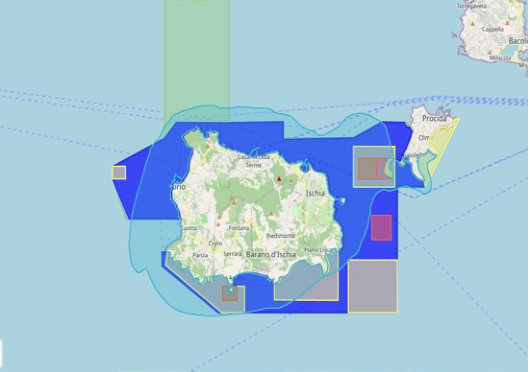
Figure 1: Zoning map of ischia, regno di nettuno marine protected area, Italy. (Source: Regno di nettuno mpa website, visited Jan 2026).
STUDY AREA: MPA “REGNO DI NETTUNO” The Marine Protected Area Regno di Nettuno, established in 2007, encompasses 11,256 hectares of marine waters surrounding the islands of Ischia, Procida, and Vivara in the Gulf of Naples. It is governed through a distinctive zoning system comprising Zones A, B, and C, complemented by Zone B n.t. (“No Take”) and Zone D for marine mammal protection, with regulated access and authorised uses ensuring sustainable resource management (MPA, 2026). Characterised by extensive Posidonia oceanica meadows and high habitat diversity, the MPA represents a biodiversity hotspot shaped by its location along a major Mediterranean climatic boundary and supports critical migratory routes and significant cetacean populations (Pace et al., 2012). In this paper, a Digital Twin (DT) framework for the MPA, based on the main objective of improving monitoring activities and data across the seagrass meadows areas. The proposed framework is conceived as a blueprint to guide the implementation of a digital system for the monitoring and protection of Posidonia Oceanica, as well as for the development and management of Blue Carbon initiatives.
METHODOLOGY
The analysis of the Marine Protected Area “Regno di Nettuno” was conducted primarily on the basis of information provided by the official website of the managing authority (MPA,2026).The methodological approach adopted in this study is grounded in a comprehensive analysis of involved stakeholders of the MPA of Ischia and data availability. The DT objective is to support the governance system and its objectives constitute a critical dimension of analysis, conceptualised as an infrastructure emerging from the interaction
172 Artioli and Borga between data availability, stakeholder practices, and decision-making authority over development trajectories and policy implementation within the MPA. The first phase consisted of a systematic analysis of data sources. The analysis includes the classification of available, obtainable, and currently non-existent data, their sources (remote and in situ), and the stakeholders to whom they pertain. This allowed defining also the potential implementations of other data sources that can be flowed into the DT system. Secondly, an informational analysis of the MPA’s activities and stakeholders’ ecosystem was conducted. This phase involved therefore mapping the spectrum of activities taking place in the MPA and the categorization into the 3 stakeholders sub- categories of i) interest holders ii) right holders iii) institutions. This dual analysis of data availability and socio-institutional landscape served to clarify the functional objectives of the Digital Twin. It established how the DT is expected to operate as a tool, which applications it should prioritise, related to which stakeholders mission and how these elements are entrelaced.
ANALYSIS Data Availability
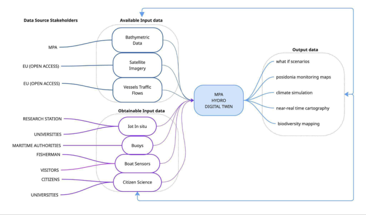
Previous case studies on Posidonia oceanica monitoring (Borga et al., 2022; Yari, 2025) highlight the absence of large-scale tools capable of assessing seagrass degradation and tracking its evolution over time, identifying this gap as a critical limitation for effective analysis, decision-making, and regulation (Borga et al., 2022). In response, the DT is an interoperable system integrating data processing and visualisation tools to support information exchange among institutions, decision-makers, and citizens, to be further developed through participatory co-design processes. Within the proposed framework, data inputs are classified into three categories according to their current availability and accessibility. 1) “Available data” refer to datasets that are already accessible without restrictions and can be directly integrated into the system. In MPA, this category includes open-access European satellite products (e.g. Copernicus Sentinel-2) and institutional datasets provided by the MPA authority, such as bathymetric maps, which support baseline monitoring of Posidonia (Borga et al., 2022; Yari, 2025). 2) “Obtainable data” comprise datasets that already exist and/or are technically compatible with the system, but whose access requires formal regulation, agreements or data-sharing protocols. For the MPA, this category primarily includes in-situ sources such as buoys (Haupt et al., 2024), onboard sensors on vessels (Ghorbani Bam et al., 2025), and citizen science contributions (Staneva et al., 2025). 3) “Currently non-existent data” refer to information that is not yet existing but could be generated in the future through the deployment of new remote or in situ sensing infrastructures (for example: MPA DT output data are yet to exist). This category highlights the system’s capacity for evolution, anticipating future monitoring needs and technological developments.
Figure 2: Diagram of available and obtainable data input and output data in mpa dt (marine protected area digital twin).
As illustrated in Fig. 2, the input data for the MPA Digital Twin are classified into available and obtainable datasets and further differentiated according to their provenance: remote sensing and in situ sources; the left column of the figure identifies the stakeholder owners and data providers associated with each data input.
Existing examples from literature show mapping of Posidonia oceanica has been conducted using available data inputs, primarily derived from remote sensing and institutional bathymetric datasets (Borga et al., 2022). Within the MPA current cartographic practices are rooted in established satellite- based, WebGIS, and geospatial methodologies (Borga et al., 2022).These approaches have enabled spatial cartographies supporting three principal outputs: (i) seagrass meadow distribution maps, (ii) anthropogenic impact maps, and (iii) coastal line impact assessments. While such representations provide a valuable descriptive baseline, they remain static and retrospective, even when based on near-real-time remote sensing products, or function primarily as descriptive outputs (Haupt et al.). For this reason, the DT framework proposed in this study integrates the available datasets with obtainable in situ data sources, enabling a real-time series of data inputs to produce dynamic, real-time adaptive data outputs. By enabling the monitoring of Posidonia oceanica health through multiple data sources, assessing meadow spatial extent and carbon sequestration capacity can underpin Blue Carbon projects that generate economic value while reinforcing ecological resilience. The integration of these heterogeneous data within a unified DT strengthens the system’s responsiveness contribution to coastal protection, biodiversity support, and water quality regulation further sustains fisheries, tourism, and coastal infrastructures, aligning environmental conservation with regenerative economic strategies. The systematic measurement of both positive and negative impacts (Pauli, 2010) is mirrored in the DT’s feedback loops, where iterative data cycles support adaptive service redesign.
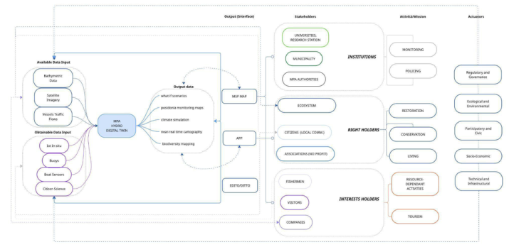
Diagram 1: Activities and stakeholders analysis of MPA ecosystem.
Stakeholders and Activities Within the framework of the Blue Economy, multi-actor cooperation is a fundamental prerequisite for sustainable and inclusive development (Pauli, 2010). Such cooperation must be supported through the creation of a shared knowledge framework enabling each stakeholder to identify their role autonomously and in alignment with the needs and activities of others. Building on previous analyses of the MPA context (Borga et al., 2022), the multiplicity of actors and the complexity of interacting dynamics necessitates continuous calibration among stakeholder activities and sustained monitoring of both anthropogenic and natural pressures. This is the foundational principle for the analysis of stakeholders and activities in order to articulate a flexible yet efficient DT structure. The activity–stakeholder mapping of MPA reveals an interwoven socio-ecological system in which knowledge production, governance, and everyday activities are mutually constitutive. This stakeholder classification identifies who participate directly in and hold roles within decision-making processes related to environmental monitoring, and which processes and interests they hold upon the environment they act/ live within,into the following three overarching categories: I) Institutions: This group includes universities, municipalities, park authorities, and coastal governance bodies, as well as territorial government agencies, infrastructure concessionaires and operators, authorities, and public environmental monitoring organisations. These actors operate within regulatory frameworks and are driven by statutory obligations defined at national, European, and international levels. II) Rights Holders: encompasses citizens, ecosystems and
A Marine Protected Area (MPA) Digital Twin 175 their constitutive components, non-profit organisations (including cultural and environmental protection associations). These actors are often among the most vulnerable to systemic change and environmental degradation. They are entitled to access, participation, and the benefits derived from environmental governance, and play a critical role in shaping socially inclusive and ecologically just outcomes. III) Interest Holders: represent the market dimension of the system and are directly engaged in operational and economic dynamics, includes stakeholders who hold economic interests as both providers and recipients of value, such as private companies, visitors, tourism-related enterprises, and commercial service entities. Following Diagram 1, the DT supports stakeholders’ activities by providing differentiated yet interconnected functions for each stakeholder group, translating integrated data streams into role-specific knowledge that underpins scientific research, governance and policy-making, conservation practices, and the regulation of socio-economic activities within the MPA. The diagram further distinguishes between direct and indirect forms of engagement: solid lines indicate stakeholders who actively and directly participate in, or influence, a given activity, while dotted lines represent indirect or mediated forms of involvement. This visual differentiation underscores the distributed nature of agency within the MPA.
MPA DT Framework Within the proposed framework, input data for the MPA Digital Twin are two complementary categories: available data, derived from open-access remote sensing platforms and institutional datasets provided by the MPA, and obtainable data, generated through in situ sources. In both cases, stakeholders are not only end users of information but also primary data providers. As illustrated in Figure 3, the MPA DT operates as a circular and adaptive data chain that continuously connects the physical marine environment with its digital representation. The process begins with the acquisition of remote and in situ data, which are integrated within the Digital Twin core and transformed into descriptive and predictive outputs, such as what-if scenarios and dynamic cartographies. These outputs articulate, in near real time, the evolving ecological and anthropogenic conditions of the MPA. The resulting data outputs are disseminated to stakeholder groups through dedicated interfaces (web applications, mobile applications, and Ocean Digital Twin environments (DITTOs)—which enable stakeholders to interact with the system according to their institutional and social roles. On the basis of these insights, stakeholders undertake activities and missions aligned with their mission, such as scientific research, policy formulation, conservation practices, and the regulation of tourism flows.For institutional stakeholders (universities, MPA authorities)it delivers scientific monitoring tools, dynamic Posidonia maps, and scenario simulations that inform research activities, policy design, regulatory enforcement, and restoration planning. For rights holders and interest holders including local communities, visitors, associations, and economic actors the DT provides accessible interfaces that guide everyday practices such as tourism, fishing, and conservation, aligning
176 Artioli and Borga them with ecological thresholds while enabling participatory contributions to data generation and environmental stewardship. These decisions are then enacted in the physical world through a series of actuators, which translate digital knowledge into regulatory, ecological, and socio-economic interventions. The DT is designed to simulate the potential effects of policies or systemic changes, thereby enabling the anticipation of both positive and negative outcomes prior to their implementation. The resulting changes in the environment generate new data that are captured by the sensing infrastructure, both in situ and remote,and reintroduced into the DT, thereby closing the feedback loop between physical and digital ecosystems.
Figure 3: MPA digital twin framework, showing data sources, data output, stakeholders and governance intertwining.
Actuators Within the proposed Digital Twin architecture, actuators constitute the operational layer through which digital insights are translated into tangible action across the Marine Protected Area. The “actuators” can be formally classified as the operational translation layer between Digital Twin data layer and real-world interventions. They mediate between simulated knowledge, stakeholder missions, and real-world interventions, enabling the system to move from representation to transformation. Five interrelated categories of actuators can be distinguished. 1) Regulatory and governance actuators convert model outputs into policy instruments and administrative decisions, such as adaptive zoning, dynamic access rules, and enforcement protocols. 2) Ecological and environmental actuators directly intervene in biophysical systems through restoration infrastructures, nature-based solutions, and adaptive protection measures that respond to ecosystem thresholds. 3) Socio- economic actuators reconfigure human activities by aligning tourism flows, fishing practices, and Blue Economy initiatives with ecological constraints and resilience objectives. 4) Participatory and civic actuators enable
A Marine Protected Area (MPA) Digital Twin 177 behavioural change and co-production by engaging citizens, visitors, and local communities through digital interfaces, educational tools, and citizen science platforms. Finally, 5) technical and infrastructural actuators sustain the adaptive capacity of the DT itself, ensuring continuous synchronisation between physical and digital systems through automated calibration.
Interfaces and Data Outputs An illustrative example of the Digital Twin operational chain within the interfaces and outputs data concerns the monitoring and restoration of Posidonia oceanica.The process begins with the acquisition of input data from both remote and in situ sources. These heterogeneous data streams are integrated within the MPA DT and transformed into dynamic Posidonia mapping cartographies, which visualise the spatial extent, health status, and temporal evolution of seagrass meadows.These outputs are accessed by stakeholders through multiple interfaces (web applications, mobile applications, and Ocean Digital Twin environments, DITTOs), enabling the identification of degraded areas and the activation of targeted actuators, including replanting interventions, protective barriers, and the deployment of new sensors. Outputs may be delivered via newly designed interfaces with direct data access or embedded within existing platforms through interoperability protocols, ensuring both low-latency interaction and continuity with established systems. On the basis of these insights, a set of actuators is activated: targeted Posidonia replanting programmes are implemented, physical barriers are installed to protect fragile zones from anchoring and trampling, and new in situ sensors are deployed in critical locations. These interventions modify the physical environment and simultaneously generate new data streams, which are reintroduced into the Digital Twin, thereby closing the feedback loop and enabling continuous adaptive management of the seagrass ecosystem.
CONCLUSION
The DT framework proposed in this study directly addresses the gap of tools capable of assessing and tracking MPA complexity evolution over time, by advancing an interoperable system that integrates data sources and information exchange among different stakeholders categories. The underlying hypothesis of the MPA DT is that such an infrastructure should not be conceived only as a repository of information derived from the capture and integration of physical environmental data, but rather as a dynamic data-driven systems approach. The DT framework enables the integration of seagrass processes at the meadow scale with high-resolution spatial and temporal datasets, thereby extending monitoring capacities across multiple dimensions. While this approach raises challenges related to interoperability, long-term sustainability, and governance, it also provides a critical opportunity to bridge existing gaps by connecting stakeholders’ ecosystems within a holistic framework aligned with conservation priorities and Blue Economy sustainability objectives.
REFERENCES
Area Marina Protetta Regno di Nettuno “L’area protetta”, AMP Regno di Nettuno Official Portal and Website, visited 10–15–18–20 Jan 2026. https://www. nettunoamp.it/area-protetta.php Arnold, R. D. and Wade, J. P. (2015) “A Definition of Systems Thinking: A Systems
Approach”, Procedia Computer Science, Vol. 44, pp. 669–678. Barbier, R., Yahia, S. B., Le Masson, P. and Weil, B. (2021) “Expanding Usages of Earth Observation Data: A CO-Design Approach to Grow an Ecosystem of Efficient Service Designers”, proceedings of the IEEE International Geoscience and Remote Sensing Symposium (IGARSS), pp. 296–299. Blair, G. S. (2021) “Digital twins of the natural environment”, Patterns, Vol. 2, No.
10, Article 100359. Borga, G., Iodice, F. and D’Acunto, F. (2022) “Open-data satellitari a supporto del Service Design: un caso studio sull’Area Marina Protetta di Ischia”, MD Journal, No. 13, Luglio 2022 Buonocore, L., Yates, J. and Valentini, R. (2022) “A Proposal for a Forest Digital
Twin Framework and Its Perspectives”, Forests, Vol. 13, No. 4, Article 498. De Koning, K., Broekhuijsen, J., Kühn, I., Ovaskainen, O., Taubert, F., Endresen, D., Schigel, D. and Grimm, V. (2023) “Digital twins: Dynamic model-data fusion for ecology”, Trends in Ecology & Evolution, Vol. 38, Durden, J. M. (2025) “Environmental management using a digital twin”,
Environmental Science & Policy, Vol. 164, Article 104018. Ghorbani Bam, P., Rezaei, N., Roubanis, A., Austin, D., Austin, E., Tarroja, B., Takacs, I., Villez, K., & Rosso, D. (2025). Digital Twin Applications in the Water Sector: A Review. Water, 17(20), 2957. https://doi.org/10.3390/w17202957 GDPR.eu (n.d.) “What is GDPR?”, General Data Protection Regulation Guide,
visited Nov 2025. https://gdpr.eu/ Haupt, S., Sibolla, B., Molapo, R., Mdakane, L., & Fourie, N. (2025a). Exploring the Use of Data in a Digital Twin for the Marine and Coastal Environment. ISPRS International Journal of Geo-Information, 14(4), 140. https://doi.org/10.3390/ ijgi14040140 Hintz, A. (2023) “Civic Participation in the Datafied Society”, Introduction. Iandelli, N. (2015) Smart Environment: Infrastrutture di monitoraggio diffuso, PhD
dissertation, Università IUAV di Venezia. Jones, D.; Snider, C.; Nassehi, A.; Yon, J.; Hicks, B. Characterising the Digital Twin: A Systematic Literature Review. CIRP J. Manuf. Sci. Technol. 2020, 29, 36–52. Larkin, K. E., Marsan, A.-A., Tonné, N., Van Isacker, N., Collart, T., Delaney, C.,
Vasquez, M., Manca, E., Lillis, H. and Calewaert, J.-B. (2022) “Connecting marine data to society”, in: Ocean Science Data, Elsevier, pp. 283–317. McKinley, E., Burdon, D. and Shellock, R. J. (2023) “The evolution of ocean literacy: A new framework for the United Nations Ocean Decade and beyond”, Marine Pollution Bulletin, Vol. 186, Article 114467. Monnier, B., Pergent, G., Mateo, M. Á., Clabaut, P., & Pergent-Martini, C. (2022).
Quantification of blue carbon stocks associated with Posidonia oceanica seagrass meadows in Corsica (NW Mediterranean). Science of The Total Environment, 838, 155864. DOI: 10.1016/j.scitotenv.2022.155864. Pace, D. S., Miragliuolo, A. and Mussi, B. (2012) “The case study of the marine canyon of Cuma (Tyrrhenian Sea, Italy): Implication for cetacean conservation off Ischia Island”, in: Würtz, M. (Ed.), Mediterranean submarine canyons: Ecology and governance, IUCN, pp. 89–97. Pergent-Martini, C. (2020) “Contribution of Posidonia oceanica meadows in
the context of climate change mitigation in the Mediterranean Sea”, Marine Environmental Research, p. 20.
A Marine Protected Area (MPA) Digital Twin 179 Pergent, G. (1994) “Primary production, stocks and fluxes in the Mediterranean
seagrass Posidonia oceanica”, Marine Ecology Progress Series, pp. 139–146. Staneva, J., Broenner, U. and the SeaDOTS Project Team (2025) “SEADOTs – Socioecological ocean management applications using Digital Ocean Twins”, One Ocean Science Congress, Nice, France. Tzachor, A., Hendel, O. and Richards, C. E. (2023) “Digital twins: A stepping stone
Human Factors in Architecture, Sustainable Urban Planning and Infrastructure
Read this individual research paper free through the original publisher, or explore the full digital proceedings book.
ISBN 979-8-950676-05-5
Explore this ISBN in the AHFE Bookstore ↗Listed in the July 2026 bookstore catalogue; search by ISBN to confirm current availability · Digital book purchase optional