Xiaohan Mei, Li Zhang (2025). Bridging Subjective Experience and Objective Measures: A Novel Method for Assessing Indoor Wayfinding Efficiency Using Virtual Environments. In: Human Factors in Architecture, Sustainable Urban Planning and Infrastructure. AHFE Open Access, vol. 191, pp. 95–105. https://doi.org/10.54941/ahfe1006613
With the accelerating pace of global urbanisation and the demand for high-quality urbanisation in China, enhancing spatial experience has emerged as a critical issue in urban-architectural design. Accurately evaluating the efficiency of built space usage from a perspective that better aligns with users' subjective experiences provides empirical evidence for urban regeneration and design decision-making. Wayfinding performance in large public buildings, as a key indicator of spatial utilisation efficiency, has become a significant interdisciplinary research focus in fields such as urban-architecture studies, human factors, and neuroscience.Traditional methods for assessing wayfinding efficiency primarily rely on two data collection approaches: individual on-site tracking experiments and spatiotemporal distribution records for groups. The former often struggles to pinpoint participants' precise positions, while the latter fails to capture specific individual behaviours during wayfinding tasks. Due to limitations in trajectory data accuracy, previous methods face challenges in precisely identifying when and where wayfinding errors, such as backtracking or looping, occur—behaviours often associated with subjective recognition of wayfinding errors. These methods typically assess wayfinding efficiency by comparing total path length with the shortest path, overlooking the role of spatial features in shaping perception during wayfinding and their alignment with subjective experiences.This study aims to establish and validate a novel objective approach for assessing indoor wayfinding efficiency that better aligns with users' subjective experiences.To address the limitations of previous methods in accurately evaluating wayfinding performance in large public buildings, this research employs a high-fidelity immersive virtual environment to collect spatiotemporal location data during wayfinding tasks. By utilising built-in scripts, the study achieves precise tracking of participants' trajectories and fixation points, significantly improving the accuracy of individual spatiotemporal data and semantic analysis of fixation points, with temporal and spatial resolutions reaching 0.05 seconds and 0.01 metres, respectively.To address the misalignment between traditional wayfinding efficiency assessment methods and subjective user experiences, this study introduces a new evaluation metric: the proportion of time spent on valid routes (defined as trajectories traversed only once, without any circular movements). This approach considers the influence of spatial features on perceptual baselines during wayfinding, producing efficiency metrics that better reflect participants’ subjective cognition in large public buildings.To validate this novel method, an experimental case study was conducted in a virtual reality environment. Data from 25 participants were collected, including approximately 1.9 × 10⁵ eye-tracking data points, spatiotemporal location records, and 25 cognitive maps. Correlation analyses between wayfinding efficiency and the accuracy of cognitive maps, combined with subjective questionnaire responses, demonstrated that the proposed method effectively captures participants’ subjective spatial cognition during wayfinding.This research provides a framework for objectively assessing indoor wayfinding efficiency that integrates subjective experiences, offering valuable insights for the design and reconstruction of large public buildings.
In the context of people-centred urbanisation in China, the development of urban spaces has shifted from solely meeting basic functional requirements to a broader focus on enhancing the overall quality of urban life. Wayfinding, defined as the process of navigating towards a destination using environmental cues (Lynch, 1964; Arthur and Passini, 2002), plays a crucial aspect of the interaction between individuals and their surroundings, significantly influencing the quality of spatial experience. Accurately evaluating wayfinding efficiency from a perspective that better reflects users’ subjective experiences has become one of the important interdisciplinary research areas, spanning urban-architecture design, human factors, and neuroscience, aiming to provide valuable empirical insights for urban regeneration and design decision-making.
Data Acquisition Methods in Wayfinding Efficiency Assessment Traditional methods for assessing wayfinding efficiency typically involve two main data collection approaches: individual on-site tracking experiments and group spatiotemporal distribution recordings. For example, Ishikawa et al. employed on-site observations to record participants’ route choices during wayfinding tasks (Ishikawa et al., 2008). Jamshidi et al. used a think- aloud protocol and digital video recording to track participants’ locations during the wayfinding process (Jamshidi and Pati, 2024). Galea et al. and Imanishi et al. analysed evacuation wayfinding trajectories of occupants in theatres through video recordings (Galea et al., 2017; Imanishi and Sano, 2019). Narimoto et al. used smartphone sensors to collect and detect individuals’ wandering actions during wayfinding (Narimoto et al., 2018). However, on-site tracking experiments and observations often carry a high degree of subjectivity in assessing wayfinding behaviour and face challenges in accurately pinpointing participants’ locations (Feng, Duives and Hoogendoorn, 2022a). Additionally, technologies such as Ultra-Wideband (UWB) and Bluetooth can be expensive and may struggle to ensure high- quality data. When recording group spatiotemporal distributions, methods like GPS and WiFi positioning are often inadequate for tracking individual wayfinding trajectories. Video imaging and machine vision methods, while capable of easily capturing human trajectories, face limitations in large public spaces due to privacy and data ethics concerns.
The advancement of virtual reality (VR) technology has enabled more precise ergonomic data collection during wayfinding tasks. Recent comparative experiments conducted in both VR and real-world settings have demonstrated that VR can be effectively used in spatial perception research (Hardless, Meilinger and Mallot, 2015; Dong et al., 2022; Liao et al., 2022; Natapov et al., 2022). Some architectural studies, particularly in the field of Urban Ergonomics, VR has been participated in the studies of environmental cue identification and cognition (Zhang et al., 2022). Wayfinding studies have also increasingly adopted VR settings to obtain higher quality and larger datasets (Vizzari, 2020; Ewart and Johnson, 2021). Many scholars have constructed wayfinding scenarios using game engines, recording participants’ precise trajectory data through embedded scripts (Vizzari, 2020), which are used to analyse individuals’ information perception (Feng, Duives and Hoogendoorn, 2022b) and behavioural preferences (Zhang et al., 2021; Kalantari et al., 2022), while also allowing for more accurate assessments of indoor wayfinding efficiency (Zhu et al., 2020; Sun, Li and Hu, 2021; Yang, 2022; Chen, Shi and Li, 2023).
Quantitative Evaluation of Wayfinding Efficiency The limitations in obtaining real-time data on participants’ locations and behaviours during wayfinding tasks have led to the proposal of alternative indicators for assessing wayfinding efficiency. Metrics such as travelled distance, time, and average speed are commonly used in these studies (Ruddle and Péruch, 2004; Holper et al., 2013; Vizzari, 2020; Ewart and Johnson, 2021). For instance, Werkhoven et al. employed travelled distance and time to
Bridging Subjective Experience and Objective Measures: A Novel Method 97
measure wayfinding efficiency in relation to various audio-visual landmarks (Werkhoven, van Erp and Philippi, 2014). Niu used the ratio of actual walking distance to the theoretical shortest distance between starting and ending points to assess wayfinding efficiency in commercial complexes (Niu, 2007). Vilar et al. used metrics such as distance travelled, time spent, number of pauses, and average speed to evaluate the effectiveness of different signage systems in wayfinding tasks (Vilar et al., 2014).
These methods, however, face challenges in accurately pinpointing behaviours such as turning back or circling, due to the limited accuracy of individual trajectory data. In many cases, participants’ travelled distances are substituted with the side length of the route. Furthermore, these methods often compare the overall route length with the shortest possible route to evaluate efficiency, without adequately considering users’ subjective perceptions of wayfinding errors in public buildings. People do not always choose the shortest path, and may not realise a wrong turn until retracing their steps (Deng, Xu and Deng, 2022). Additionally, using the route length as a measure does not account for changes in perception during wayfinding due to other spatial characteristics. It also fails to consider the varying difficulty of wayfinding based on subjective experience.
Building on the analysis above, this study aims to establish a novel objective approach for assessing indoor wayfinding efficiency using virtual environments, better aligning with users’ subjective experiences. Furthermore, this study will experimentally test whether the proposed method effectively captures participants’ subjective spatial cognition during wayfinding, seeking to provide a foundation for quantifying the challenges present in real-world wayfinding and to offer user- centred methods for enhancing wayfinding efficiency in large public buildings.
METHODS
Ergonomic analysis methods often consider time as a fundamental measure of the intensity of interaction between individuals and spatial interfaces (Zhang et al., 2022). In line with this perspective, we define a valid route as the path taken by a subject that involves no detours and is only traversed once. The ratio of the time spent on the valid route to the total wayfinding time is then used as an evaluation metric for wayfinding efficiency. This approach allows for the construction of a wayfinding efficiency calculation method that more closely reflects participants’ subjective experiences.
Building on the insights and limitations from previous research on wayfinding efficiency, we propose a novel method for assessing indoor wayfinding efficiency, as outlined below.
Step 1: Simulation Modelling of Built Space Samples 3D scanning and other technologies are employed to capture samples of the built environment. Based on the collected data, an immersive environment in computer is created, which outputs the player’s
98 Mei and Zhang
position coordinates and timestamps at each frame through embedded scripts.
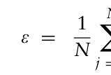
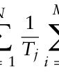
Step 2: Establishment of an Evaluation Index for Wayfinding Efficiency An evaluation index for wayfinding efficiency is developed,
N X
Mj X EijTij (1)
Equation reproduced from the original PDF.Equation reproduced from the original PDF.
In the equation, ε represents the wayfinding efficiency; N represents the total number of participants; Tj represents the total wayfinding duration of the j-th subject; Mj represents the total number of samples collected during the wayfinding process of the j-th subject; Eij represents the wayfinding status of the j-th subject within the i-th sampling interval; and Tij represents the duration of the i-th sampling interval for the j-th subject.
For the wayfinding status Eij,
Eij =
1, if the subject is on the valid route 0, if the subject is on the invalid route (2) Step 3: Recruitment of Participants to Perform Wayfinding Tasks in the Immersive Environment
Participants are recruited to perform wayfinding tasks in the immersive environment created in Step 1, with clearly defined starting points and destinations.
Step 4: Collection of Human Factors Data During Wayfinding Participants’ positions are tracked at each frame via the embedded script from Step 1. Position coordinates (PosXij, PosZij, PosYij) and corresponding timestamps Tij for each participant are recorded during the wayfinding task.
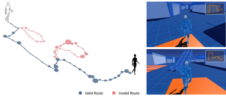
Step 5: Determination of Valid Route A valid route is defined as the trajectory that a subject follows only once, without any circular movements (see Figure 1). For each participant, a valid route must meet the following three conditions:
The route must be continuous, extending from the starting point to the final destination.
The trajectory in an area is considered part of the valid route only when the participant passes through it for the final time.
If the subject traverses the same region multiple times, the trajectory between the initial arrival and the final arrival is considered invalid.
Bridging Subjective Experience and Objective Measures: A Novel Method 99
Figure 1: Diagram of wayfinding efficiency evaluation method (left) and real-time assessment in the digital twin environment (right) (source: authors).
Step 6: Evaluation of Wayfinding Efficiency The total wayfinding time Tj and the timestamps Tij indicating whether the participant is on the valid route are substituted into the wayfinding efficiency evaluation model described in Step 2, in order to calculate the wayfinding efficiency ε for the experimental sample space.
The evaluation method of wayfinding efficiency established in this study uses time as the benchmark, considering the changes in perception benchmarks during the wayfinding process brought about by spatial characteristics. At the same time, the valid route replaces the shortest path commonly used in previous studies, making the resulting wayfinding efficiency more aligned with people’s subjective cognition when navigating through public buildings.
CASE ANALYSIS AND VALIDATION To validate whether the proposed method for assessing indoor wayfinding efficiency more accurately reflects people’s subjective experiences during wayfinding, we selects the B1 level of a university building located in Beijing, China, as the spatial sample for the wayfinding experiment.
Validating Measures As a classic and well-established approach to study urban spatial elements from the perspective of people’s cognition, the possibility of cognitive map as a measure of spatial structure cognition is self-evident. Kevin Lynch (1964) studied the shared characteristics of residents’ experiences of urban space by inviting participants to draw their own memories of urban spaces. The more closely the cognitive map drawn by the subject matches the actual space, the clearer and more perceptible the spatial structure of the city is -- this concept was named Legibility/Imageability by Lynch. In the context of indoor wayfinding, we can argue that the higher the accuracy of the cognitive map
100 Mei and Zhang
drawn by the subject, the more easily the interior space structure is perceived, and the better the subject’s spatial experience during wayfinding.
In subsequent research, cognitive maps have evolved into two types: one depicts the five elements of spatial structure – path, node, landmark, edge, and district – while the other is to draw the specific routes taken (Arthur and Passini, 2002). To quantify the accuracy of spatial structure cognition, we adopt the second type of cognitive map, comparing the map drawn by the subject with the actual trajectory derived from the spatial-temporal data of the same individual, and uses their similarity as a quantitative indicator to analyse its correlation with wayfinding efficiency. In previous research, bidimensional regression has been used to scale, translate, and rotate cognitive maps to obtain their predicted locations, thereby reflecting the degree of distortion of the cognitive map relative to the actual map (Friedman and Kohler, 2003). This study will use bidimensional regression and mean squared error (MSE) calculations to measure the overall difference between the cognitive maps drawn by participants and their actual trajectories during wayfinding. The smaller the MSE value, the smaller the difference between the points on the cognitive map and the points in the actual trajectory, indicating higher accuracy of the cognitive map.
Additionally, we will also assess whether participants felt disoriented during the experiment as a supplementary measure to validate the subjective experience of the wayfinding process.
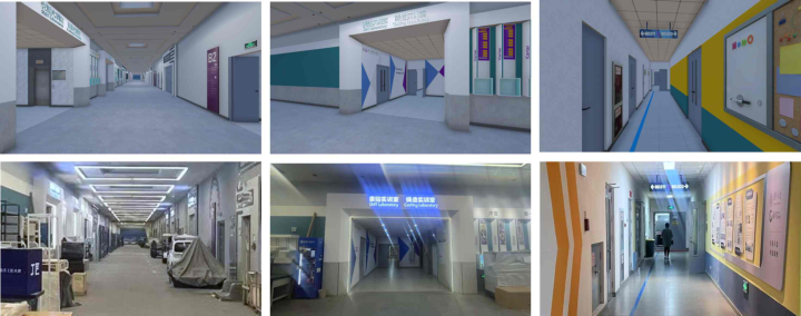
Experimental Environments and Apparatus We used the HTC VIVE PRO EYE headset (sampling rate 120 Hz) and controllers to display wayfinding scenario in a lab environment. The spatial sample of the teaching building’s B1 level was captured using on-site photography and reconstructed into an immersive environment using the Unity engine (see Figure 2). The participants’ subjective rating of the scene’s simulation level averaged 85.74/100. Spatiotemporal location data were collected via built-in C# scripts.
Based on field observations, there are typically two common wayfinding scenarios in the sample space. The first involves finding a specific classroom after entering the windowless space via vertical transportation. The second scenario occurs after completing activities in the classroom, where individuals need to navigate back to the elevator to exit the space. As these tasks often occur within the same visit, both wayfinding scenarios are included in the study, with each subject required to complete them sequentially.
Participants This study engaged 24 participants, including 13 females and 11 males, aged between 18 and 40 years (M = 25.5, SD = 4.4). The participants represented a diverse range of 16 academic and professional disciplines, with 4 individuals specialising in architecture. Of the participants, 23 were right-handed, and 1 was left-handed.
Bridging Subjective Experience and Objective Measures: A Novel Method 101
Figure 2: Comparison between on-site photographs (top) and virtual simulation models (bottom) (source: authors).
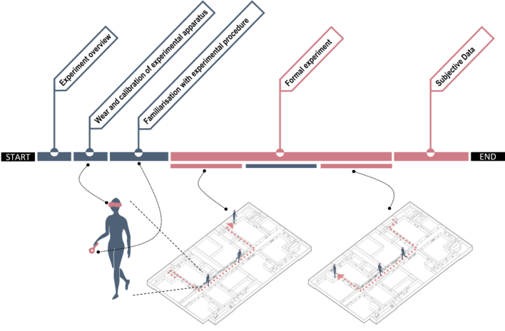
Experimental Procedure The experiment involved five steps: experimental introduction, equipment wearing and calibration, familiarization with the experimental process, formal experiments and data collection, and the completion of subjective questionnaires (see Figure 3).
After wearing the VR headset and familiarizing themselves with the controller operation, participants began the wayfinding task in the immersive environment from the entrance of the teaching building’s B1 level, relying on the scene’s information to find the target classroom. Once the participants believed they had reached the destination classroom, they verbally confirmed
102 Mei and Zhang
the arrival, and the program was closed to finalize the data recording. After a 10-minute break simulating classroom activity, the participant was instructed to return independently to the initial underground entrance. Again, they confirmed arrival verbally, and data collection was completed. If a participant felt unable to find the destination, they reported the wayfinding failure verbally, and the program was closed with wayfinding efficiency recorded as 0%. Afterward, the VR headset was removed, and participants were instructed to draw cognitive maps for both tasks.
Results
A total of 24 participants completed 48 wayfinding tasks in the VR environment of the spatial sample. 44 sets of data were considered valid. The collected data included approximately 9.95×10⁵ frames of spatiotemporal location data.
Using the method described in this study, the wayfinding efficiency of the participants was evaluated. The results showed relatively low wayfinding efficiency. Specifically, when targeting a particular classroom as the destination, the average efficiency was only 36.7%, with one participant failing to find the way. When the destination was the initial entrance, the wayfinding efficiency of the participants significantly improved but still only reached 62.5%, with two participants failing to find the initial entrance.
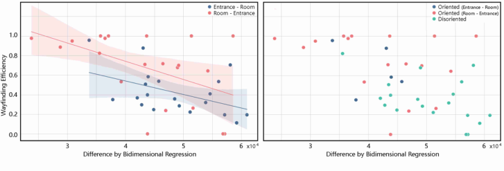
Further analysis was conducted on the correlation between participants’ wayfinding efficiency and the accuracy of their drawn cognitive maps. Bidimensional regression and mean squared error (MSE) calculations were used to measure the difference between the cognitive maps drawn by participants and their actual trajectories during wayfinding. The results of the correlation test between cognitive map accuracy and wayfinding efficiency in the spatial sample are presented in Figure 4 (left). The larger the abscissa, the greater the difference between the cognitive map and the actual trajectory, indicating lower accuracy of the cognitive map. It was found that in the two tasks – finding a specific classroom and returning to the initial entrance – wayfinding efficiency was significantly related to the accuracy of the cognitive map route drawing (p = 0.038, p = 0.020). This suggests that the more accurately the participants perceive the indoor space structure, the higher the wayfinding efficiency based on the method proposed in this study.
The correlation further indicates that the wayfinding efficiency assessment method established in this study effectively reflects the clarity of the participants’ spatial cognition during the wayfinding process.
Additionally, participants were asked if they felt disoriented during the experiment. Of the 22 tasks with the classroom as the destination, 16 participants reported feeling disoriented; and of the 22 tasks with the initial entrance as the destination, 5 participants reported feeling disoriented. As shown in Figure 4 (right), participants who reported feeling disoriented had a significantly lower average wayfinding efficiency compared to those who did not (p = 0.044). This further supports the validity of the wayfinding efficiency evaluation method established in this study, as it reflects the subjective experience of the participants during wayfinding.
Bridging Subjective Experience and Objective Measures: A Novel Method 103
Figure 4: Scatter diagram of cognitive map difference and wayfinding efficiency (source: authors).
CONCLUSION
This study establishes and validates a novel objective approach for assessing indoor wayfinding efficiency that better aligns with users’ subjective experiences.
To address the limitations of previous methods in accurately evaluating wayfinding performance in large public buildings, this research employs a high-fidelity immersive virtual environment to collect spatiotemporal location data during wayfinding tasks. By utilising built-in scripts, the study achieves precise tracking of participants’ trajectories, significantly improving the accuracy of individual spatiotemporal data with temporal and spatial resolutions reaching 0.05 seconds.
To address the misalignment between traditional wayfinding efficiency assessment methods and subjective user experiences, this study introduces a new evaluation metric: the proportion of time spent on valid routes. This approach considers the influence of spatial features on perceptual baselines during wayfinding, producing efficiency metrics that better reflect participants’ subjective cognition in large public buildings.
To validate this novel method, an experimental case study was conducted in a virtual reality environment. Correlation analyses between wayfinding efficiency and the accuracy of cognitive maps, combined with subjective questionnaire responses, demonstrated that the proposed method effectively captures participants’ subjective spatial cognition during wayfinding.
This research provides a framework for objectively assessing indoor wayfinding efficiency that integrates subjective experiences, attempts to valuable insights for the design and reconstruction of large public buildings.
As human-centred technologies become increasingly mature in architecture, physiological measurements such as eye-tracking, electrodermal activity, and EEG are also being used to assess people’s perceptual preferences and emotional valence during wayfinding. Future research could consider integrating multiple human factor metrics to further align wayfinding efficiency assessment methods with subjective experiences. Additionally, while this study uses the time participants spend fixating on directional signage as an indicator of route decision states, future research could refine
104 Mei and Zhang
this by selecting more precise decision states based on human factor data characteristics, further improving the accuracy of wayfinding efficiency evaluations.
ACKNOWLEDGMENT
This study is funded by the China National Key R&D Programme (No. 2022YFC3801500).
REFERENCES
Werkhoven, P., van Erp, J. B., & Philippi, T. G. (2014). Navigating virtual mazes: The benefits of audiovisual landmarks. Displays, 35(3), 110-117. Arthur, P. and Passini, R. (2002) Wayfinding: People, Signs, and Architecture. Focus
Strategic Communications. Chen, J., Shi, Y. and Li, N. (2023) ‘The role of selective attention in emergency wayfinding: An eye tracking-integrated virtual reality experiment’, Safety Science, 168, p. 106320. Deng, H., Xu, Y. and Deng, Y. (2022) ‘Is the Shortest Path Always the Best? Analysis
of General Demands of Indoor Navigation System for Shopping Malls’, Buildings, 12(10), p. 1574. Dong, W. et al. (2022) ‘Wayfinding Behavior and Spatial Knowledge Acquisition: Are They the Same in Virtual Reality and in Real-World Environments?’, Annals of the American Association of Geographers, 112(1), pp. 226–246. Ewart, I. J. and Johnson, H. (2021) ‘Virtual reality as a tool to investigate and predict
occupant behaviour in the real world: The example of wayfinding’, ITcon, 26, pp. 286–302. Feng, Y., Duives, D. C. and Hoogendoorn, S. P. (2022a) ‘Development and evaluation of a VR research tool to study wayfinding behaviour in a multi-story building’, Safety Science, 147, p. 105573. Feng, Y., Duives, D. C. and Hoogendoorn, S. P. (2022b) ‘Wayfinding behaviour in
a multi-level building: A comparative study of HMD VR and Desktop VR’, Adv. Eng. Inform., 51(C). Friedman, A. and Kohler, B. (2003) ‘Bidimensional Regression: Assessing the Configural Similarity and Accuracy of Cognitive Maps and Other Two- Dimensional Data Sets’, Psychological Methods, 8(4), pp. 468–491. Galea, E. R. et al. (2017) ‘Evacuation response behaviour of occupants in a large
theatre during a live performance’, Fire and Materials, 41(5), pp. 467–492. Hardless, G., Meilinger, T. and Mallot, H. A. (2015) ‘Virtual Reality and Spatial Cognition’, in International Encyclopedia of the Social Behavioral Sciences. Elsevier Science, pp. 133–137. Holper, L. et al. (2013) ‘Error detection and error memory in spatial navigation as
reflected by electrodermal activity’, Cognitive Processing, 14(4), pp. 377–389. Imanishi, M. and Sano, T. (2019) ‘Route Choice and Flow Rate in Theatre Evacuation Drills: Analysis of Walking Trajectory Data-Set’, Fire Technology, 55(2), pp. 569–593. Ishikawa, T. et al. (2008) ‘Wayfinding with a GPS-based mobile navigation system:
A comparison with maps and direct experience’, Journal of Environmental Psychology, 28, pp. 74–82. Jamshidi, S. and Pati, D. (2024) ‘Identifying Environmental Elements and Attributes that Contribute to Indoor Wayfinding: An Exploratory Study Utilizing Think- Aloud Protocol’, Journal of Interior Design, 49(2), pp. 117–138.
Bridging Subjective Experience and Objective Measures: A Novel Method 105
Kalantari, S. et al. (2022) ‘Evaluating the impacts of color, graphics, and architectural features on wayfinding in healthcare settings using EEG data and virtual response testing’, Journal of Environmental Psychology, 79, p. 101744. Liao, H. et al. (2022) ‘Exploring Eye Movement Biometrics in Real-World Activities:
A Case Study of Wayfinding’, Sensors, 22(8), p. 2949. Lynch, K. (1964) The Image of the City. The MIT Press. Narimoto, R. et al. (2018) ‘Wayfinding Behavior Detection by Smartphone’, in 2018 IEEE 32nd International Conference on Advanced Information Networking and Applications (AINA), pp. 488–495. Natapov, A. et al. (2022) ‘Architectural features and indoor evacuation wayfinding:
The starting point matters’, Safety Science, 145, p. 105483. Niu, L. (2007) Spatial cognition and wayfinding in architectural complexes: A case study of commercial complexes, Doctoral dissertation, Tongji University. Ruddle, R. A. and Péruch, P. (2004) ‘Effects of proprioceptive feedback and
environmental characteristics on spatial learning in virtual environments’, International Journal of Human-Computer Studies, 60(3), pp. 299–326. Sun, C. et al. (2021) ‘Evaluation method of passenger wayfinding efficiency in terminals after opening: A case study of Shanghai Pudong International Airport Satellite Hall’, Architectural Journal, (S1), pp. 169–174. Vilar, E. et al. (2014) ‘Effects of competing environmental variables and signage
on route-choices in simulated everyday and emergency wayfinding situations’, Ergonomics, 57(4), pp. 511–524. Vizzari, G. (2020) ‘Virtual Reality to Study Pedestrian Wayfinding: Motivations and an Experiment on Usability’, in 2020 IEEE International Conference on Artificial Intelligence and Virtual Reality (AIVR). 2020 IEEE International Conference on Artificial Intelligence and Virtual Reality (AIVR), pp. 205–208. Yang, Y. (2022) Research on cognitive mechanisms and design strategies of
wayfinding in commercial building spatial environments, Doctoral dissertation, Harbin Institute of Technology. Zhang, L. et al. (2022) ‘Urban Ergonomics: A design science on spatial experience quality’, Chinese Science Bulletin, 67(16), pp. 1744–1756. Zhang, M. et al. (2021) ‘Investigating the influence of route turning angle on
compliance behaviors and evacuation performance in a virtual-reality-based experiment’, Advanced Engineering Informatics, 48, p. 101259. Zhu, R. et al. (2020) ‘Influence of architectural visual access on emergency wayfinding: A cross-cultural study in China, United Kingdom and United States’, Fire Safety Journal, 113, p. 102963.
LISTED IN THE AHFE DIGITAL BOOKSTORE CATALOGUE
Explore the complete digital volume
Human Factors in Architecture, Sustainable Urban Planning and Infrastructure
Read this individual research paper free through the original publisher, or explore the full digital proceedings book.
ISBN 978-1-964867-67-0
Explore this ISBN in the AHFE Bookstore ↗Listed in the July 2026 bookstore catalogue; search by ISBN to confirm current availability · Digital book purchase optional