Diego Maruri, Gabriela Vega (2022). Urban green network for the urban area of Milagro, Guayas, Ecuador. In: Human Interaction & Emerging Technologies (IHIET 2022): Artificial Intelligence & Future Applications. AHFE Open Access, vol. 68, pp. 159–165. https://doi.org/10.54941/ahfe1002727
Currently, a large part of the urban population resides in cities where there is little or almost no relationship between nature and the urban environment, which is a fundamental parameter for achieving quality of life for people. On the other hand, the disorderly and accelerated growth of informal settlements in search of different economic activities in recent years in the canton of Milagro, and the unbridled development of the sugar and cocoa agroindustry, has led to the deforestation of the native forest areas of the canton. The objective of this study is to promote the conservation and creation of new green areas in the urban area of Milagro by identifying and incorporating native tree species of the sector, which should be compatible with the ecosystems. In order to determine the needs of each sector, we identify and analyze the available useful green area surfaces, through the use of precision spatial geographic software that allows us to establish the exact areas of the territory under study and to relate them to the current population to arrive at the analysis of the urban green area index (U.G.I.), with the aim of establishing the urban green area index (U.G.I.), in order to create new spaces of green areas, with the result of increasing the index of urban green area within the parameters established by the Ministry of Public Health of Ecuador (M.P.H.), and establish a strategic planning as a consolidated axis for the city based on green concepts linked to sustainable land use planning.
The importance of green areas is growing, they play an important role in improving the quality of the urban environment, since these spaces inside cities, especially those that have a high percentage of vegetation cover, can provide several ecological benefits such as: decreasing the intensity of heat islands, increasing CO2 and reducing air pollution (Segarra et al. 2021), aspects that are directly related to the health and well-being of the urban inhabitant, as a positive impact on the quality of life, resulting in an indi- cator of ecological sustainability by maintaining the natural capital, that is, living within the productive capacity of the planet (Salinas et al. 2020). In this context, and considering that the transformations associated with urban growth impose particular internal dynamics on cities, the planning and mana- gement of green areas should be considered within public policies at all levels of government, as has been contemplated for some time in some developed countries.
The sector to intervene: the urban center, conceived as the main popula- tion center of the canton of Milagro, where the highest density of industry and commerce is concentrated, shows a high level of soil fragmentation due to the accelerated urbanization process that has generated the current problems: deficit of natural green conservation areas and green spaces, a situation that
is exemplified in a timely manner in the lack of functional green spaces throu- ghout the urban area and the increase of informal settlements with high risk of vulnerability that cause pollution on the banks of the Milagro River, by not preserving the protection strip of the river. With the proposal of the urban green network through the implementation of public development policies that allow for the creation of urban conservation zones, we aim to increase the green area per inhabitant index, and the integration of the components of the natural environment that are part of the urban area of the canton of Milagro. Guayas, Ecuador.
In addition, green infrastructure is conceived as a key element in the defi- nition of a sustainable territorial model, which is aimed at connecting not only people with each other, but also people with nature, helping to preserve biodiversity and quality by acting as elements for the protection and con- servation of the historical, cultural and natural heritage associated with it (PDyOT Milagro, 2025). It is a new way of planning and managing the terri- tory based on a network of natural and semi-natural spaces that offer various ecosystem services, taking on special importance in the urban environment for its contribution to improving the quality of life, biodiversity conservation and linkage with the rural context.
METHODOLOGY
The sector to intervene corresponds to the urban area of Canton Milagro where there is a marked deficit of green areas available for the inhabitants, which is the basis of this research. Two types of research designs were used: exploratory and descriptive methodology.
In the exploratory methodology and in relation to the diagnosis of the cur- rent situation of the urban green of the sector to be intervened, we worked on an urban scale that corresponds to the existing urban limits where two main components were determined; the structuring elements such as: water system, relief and high elevations, natural spaces and public spaces; and conditioning elements such as: risks, road system, urban stain, nodes and landmarks and edges and districts. In this section, a direct survey was used as a quantitative tool to get closer to the residents of the different sectors of the urban area of the canton of Milagro, in order to learn about the needs and importance of green public spaces.
The descriptive methodology made it possible to identify and determine on site all available and existing green areas in the urban area of the San Francisco de Milagro canton with GNSS RTK precision receiver equipment, in order to be able to inventory all these spaces, and to have the information of the accumulated area available for the study area, and to know the current situation of the green area index per habitant. At this stage we worked with tools such as tape, total station, and inputs such as photo mosaic orthophoto, which will allow validating the information taken.
Delimitation of the Study Area San Francisco de Milagro belongs to the province of Guayas and is located southeast of the Guayas River Basin, bordering the Taura River watershed
Proposal for an Urban Green Network for the Urban Area of Milagro, Guayas, Ecuador 161
Table 1. Analysis of existing green area in Canton Milagro.
Table available in the original PDF paper.
Existing Urban Green Area Projected Population 2022 Green Area Per Person 415143.68 m2 164178 hab. 2.93 m2/hab.
and includes the sub-basins of the Jujan River to the north and the Yaguachi River sub-basin. It has an approximate area of 404.96 km2. According to the Population and Housing Census conducted by INEC - National Institute of Statistics and Census (Instituto Nacional de Estadísticas y Censos). (INEC, 2016) for the year 2022, the canton of Milagro has a total population of 204,914 inhabitants, of which 164,178 inhabitants are located in the city or urban area of the canton. The canton’s headwaters together with the urban areas of the rural parishes correspond to 7.67% of the total area of the can- ton, so 92.32% corresponds to the rural area, where the hamlets and crops are located, in addition to the productive area there are industries, facilities, commercial and service corridors, etc.
Needs or Requirements of the Area (Green Area) According to the Ministry of Public Health of Ecuador MPS, specifically in the Manual for the certification of healthy municipalities in Ecuador, a docu- ment which establishes urban green areas of 9 m2 per inhabitant in line with the WHO recommendation per inhabitant, however, according to the INEC - National Institute of Statistics and Censuses (INEC, 2016) the green area index, which is the amount of green areas or land areas of particular natu- ralistic or historical-cultural interest in the territory, depends on the type of city, so there is a high variability in the indicator of square meters (m2) per inhabitant, which could be associated with the socioeconomic levels of the inhabitants and the type of city and society.
According to the study “Urban Green Index” conducted by the Institute of Statistics and Census INEC in 2012 whose results showed the lack of these spaces where vegetation abounds in the canton to show a deficit of 8.18m2 per inhabitant in the canton Milagro placing it in the penultimate place in the province of Guayas in compliance with international standards. According to information contained in the Development and Land Use Plan (D.L.U.P.) of Milagro, the urban green index in the cantonal capital currently corresponds to 2.93 m2/inhabitant (see Table 1), this calculation is obtained by adding the green areas and the square meters of green areas along the riverbanks.
Analysis of Plant Species in the Area According to CLIRSEN (2009), a total richness of 33 species was determi- ned in the canton of Milagro, whose most numerous plant families were MELIACEAE (4spp.) and BIGNONIACEAE (3spp.).
The analysis of the plant species of the area is essential for a correct under- standing of the reality of the site. To obtain information on the representative plant species of the sector, an exploratory method was used with quantitative tools such as visual analysis cards that allowed the recognition of the type of
162 Maruri and Vega
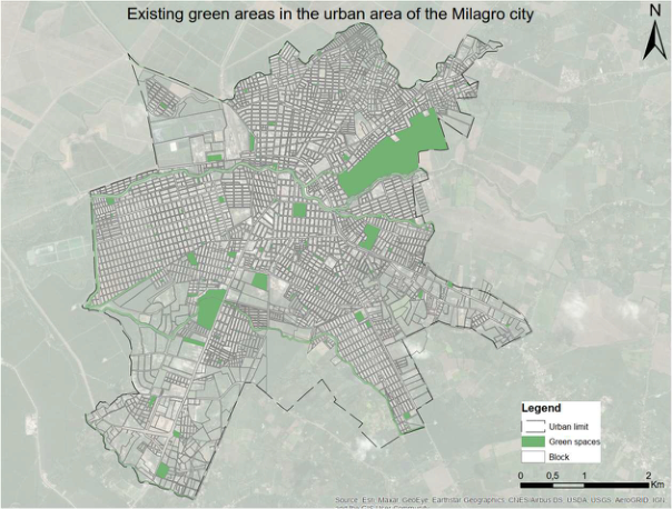
Figure 1: Existing green areas in the urban area of the Milagro city.
vegetation that exists in each of the sectors that are part of the urban area of the canton of Milagro.
Calculation of the Urban Green Index (U.G.I.)
With the result obtained from the applied methodologies where the variables: green areas and population density were considered, the following statistical formula was applied; U.G.I. - urban green index is equal to the total green areas (m2) divided by the number of inhabitants of the study area.
RESULTS
Current Status of the Zone Having collected all the information on green areas and wooded areas avai- lable in the urban area of the canton of San Francisco de Milagro, precise and accurate thematic maps were prepared (see Figure 1), with information on areas, location and service coverage to the population of the city through ArcMap software, allowing a comparison with model maps of other cantons, showing whether it meets the optimal green area per capita index as esta- blished by the Ministry of Public Health of Ecuador and the World Health Organization (WHO).
U.G.I. Deficit in the Canton of Milagro With the analysis, the Urban Green Index (U.G.I.) deficit was established, and how much is the missing area to enter within the parameters established by the regulatory entities. Once the comparison has been made, and the square meters needed to mitigate the problem have been established, the model for
Proposal for an Urban Green Network for the Urban Area of Milagro, Guayas, Ecuador 163
Table 2. U.G.I. in Milagro.
Table available in the original PDF paper.
U.G.I. Deficit
Existing Urban Green Area
Green Area Per Person
Projected Population 2022
Minimum Urban Green Index According to M.S.P. Ecuador 415143.68 m2 164178 hab. 2.93 m2/hab. 9.00 m2/hab. 6.07 m2/hab.
Table 3. Table of endemic plant species of Milagro.
Table available in the original PDF paper.
Code Gender (Family) Scientific Name 001 Pseudobombax millei (Standl.) 002 A. Robyns (Bombacaceae) 003 Muntingia calabura L. (Flacourtiaceae) 004 Matisia cordata Bonpl. (Malvaceae) 005 Theobroma cacao L. (Malvaceae) 006 Inga spectabilis (Vahl) Willd. (Mimosaceae) 007 Cecropia litoralis Snethl. (Urticaceae) 008 Ficus maxima Mill. (Moraceae)
the creation of new public green spaces in the urban area of the canton of Milagro can be obtained (see Table 2).
Plant Species Endemic to the Study Area From the field visit and the use of biotic monitoring during the dry season, the following endemic species were identified in the urban area of Milagro (see Table 3).
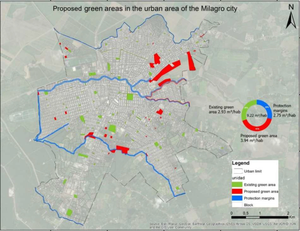
Proposal With the diagnosis of the sector to be intervened, we intend to create an “Urban green network for the urban area of the Canton of Milagro” (see Figure 2) formed by a system of corridors of green surfaces that allow the creation of new public green spaces, the connection with the existing ones in the urban area of the Canton of Milagro that allows among other aspects the free movement of people, species of fauna between the different components of the canton, with the objective of defining a road map that contemplates the organization, orientation and implementation of a set of actions of mana- gement and sustainable planning not only of the sector to intervene but of the whole city.
Among the strategies considered in the proposal “Urban green network for the urban area of Canton Milagro” is the creation of conservation areas that will encourage the reforestation of the banks of the water bodies that are part of the urban area of Canton Milagro with identified endemic plant species. The actions of the proposal “Urban green network for the urban area of Canton Milagro” are articulated in five axes of intervention, all of them aligned to the proposed strategic objectives:
164 Maruri and Vega
Figure 2: Proposed model map of the study sector.
Urban parks: natural conservation and recreation areas of medium and large extension, which allow a large service coverage.
Pocket parks: generation of public spaces from the recycling of city remnants that are usually relatively small and located on abandoned land in poor condition.
Urban green connectors: natural green connectors that can be found in rivers, streams and trails; and artificial green connectors that can be developed in primary, secondary and complementary roads.
Conservation areas: urban forests can be natural green areas in risk areas.
CONCLUSION
The implementation within the urban management of the concept of green infrastructure understood as a network that connects green spaces and sur- faces in the canton of San Francisco de Milagro will not only create a greater environmental, cultural and visual value, but will also serve as a basis for adequate territorial planning in order to improve environmental quality and mitigate the effects of environmental pollution, which is the main problem of cities worldwide.
Likewise, the proposal is conceived and managed as a solution based on nature and is a type of infrastructure necessary to implement in the canton because it fulfills multiple functions and in turn generates various benefits not only environmental, social and economic for the population by functioning as buffers against the intense actions of the climate that allow the recovery of urban eco-systems.
The implementation of the proposal defines the planning of the city as a strategic model where the proposed nuclei and connectors represent the
Proposal for an Urban Green Network for the Urban Area of Milagro, Guayas, Ecuador 165
points to follow to define the use and management of urban land, under- standing that the urban green network functions as an integrating unit of the city with nature, generating a connection of landscapes with urban envi- ronments, motivating the involvement of institutional management processes with environmental regulatory guidelines. Also through its implementation, the conservation and recovery of ecosystem services is considered, achieving the adaptation not only of the study sector but of the entire canton, to climate change in order to counteract the effects caused by the spatial fragmentation of the territory.
REFERENCES
Asamblea Constituyente de Montecristi, “Constitución de la República del Ecuador,” Quito Ediciones Legales, 2008. Instituto Nacional de Estadísticas y Censos, Inec, (2016). “Ecuador en cifras”
Website: https://www.ecuadorencifras.gob.ec Objetivos de Desarrollo Sostenible ODS, (2016). Website: https://www.un.org/susta inabledevelopment/es/sustainable-development-goals/ Plan de Desarrollo y Plan de Ordenamiento Territorial del cantón San Francisco de
Milagro 2015–2025. Website: https://milagro.gob.ec/wp-content/uploads/2021/ 04/gadmm019-201.pdf Salinas J., Vega G., Hechavarría Hernández J.R. (2020). Green Areas Plan with Native and/or Endemic Plants for Mitigation of Heat Island in Letamendi Parish, Guayaquil. En: Charytonowicz J. (eds) Advances in Human Factors in Archite- cture, Sustainable Urban Planning and Infrastructure. AHFE 2020. Advances in Intelligent Systems and Computing, vol 1214. Springer, Cham, https://doi.org/10. 1007/978-3-030-51566-9_9 Segarra G., Torres M., González C. (2021). Loja’s Urban Green System as a structu-
ring base of the city Estoa. Magazine of the Faculty of Architecture and Urbanism of the University of Cuenca. https://doi.org/10.18537/est.v010.n020.a05
Read this individual research paper free through the original publisher, or explore the full digital proceedings book.
ISBN 978-1-958651-44-5
Explore this ISBN in the AHFE Bookstore ↗Listed in the July 2026 bookstore catalogue; search by ISBN to confirm current availability · Digital book purchase optional