Darwin Nevárez, Blanca Indaburo (2022). Pedestrian corridor for the integration of the administrative, financial, and commercial center in the city Esmeraldas, Ecuador. In: Human Interaction & Emerging Technologies (IHIET 2022): Artificial Intelligence & Future Applications. AHFE Open Access, vol. 68, pp. 123–129. https://doi.org/10.54941/ahfe1002722
The investigative work shows the spatial problems of the urban area of the city of Esmeraldas, Ecuador; along 690 meters of Ave. Simón Bolívar. This site presents problems related to the deterioration of the urban image, vehicular congestion, and environmental noise due to human interaction in the sector. The research proposes the creation of a pedestrian corridor that integrates the administrative, financial, and commercial center of the urban center of the city of Esmeraldas as a strategy to improve pedestrian mobility. The proposed methodology is of a mixed type. Measurement and information-collection instruments such as observation, statistical analysis, interview, vehicle-capacity measurements, and environmental noise were used. The analysis of the results obtained corresponds to the dynamics of the urban historic center. This leads to the interpretation that noise, vehicular congestion, and the daily influx of citizens carrying out activities provoques chaos and environmental impact. The creation of a pedestrian corridor is proposed as a solution to the urban problems of the study approach, in order to offer citizens an inclusive public space in which the pedestrian is privileged, guaranteeing their mobility and contributing to the reduction of environmental pollution and vehicular traffic.Keywords: public space, pedestrian mobility, walkability, pedestrian corridor, vehicular congestion, environmental noise.
Migratory processes, industrial and urban growth have modified human set- tlements, also transforming the way we move from one place to another. The excessive concept of using public space to privilege automobiles results in the feeling that some cities are not designed for people, but for cars (Daher, 2017). The street is the most important public space in the urban area, it often represents the largest area of public space in a city, however, despite its impor- tance, streets are considered one of the most forgotten forms of public space because their formal feature favors the needs of cars. For streets to become better places, we must first of all: think about them, design them, manage them, and program them as places for people (Wallace and Zaugg, 2019). In this context, those concepts that define the use and function of the street
as such should be considered; Thus, in terms of use, the street as a public space is considered as the physical support, the daily scenario of collective urban social interactions and is physically characterized by its accessibility; and from the point of view of the function fulfilled by the street, three types can be considered: the social function, the cultural function and the politi- cal function (Dziekonsky et al., 2015). Thus, another way to determine the function of the street is to establish the external activities that are carried out in it, in this way they can be divided into three categories: necessary activities, optional activities and social activities (Gehl, 2006).
Pedestrianizations have been conceived as an urban planning tool to order space, so that pedestrians can make use of public space, but this action of mobility management must also serve to order traffic in cities, in other words, they must be integrated interventions in urban transport projects (Castro, 2018). Based on these concepts and as a reference for the approach of pedestrian corridors, The Ramblas of Barcelona is taken as an example, considered one of the most representative pedestrian corridors in the world and one of the most emblematic public spaces of that city, which has become for more than five centuries a central place where commercial, institutional financial activity and the representation of the urban scene converge in an integrated way (Ospina-Tascón, 2014); other references that are considered are: the pedestrianization of Francisco I. Madero Street, which responds to an intervention that is part of a Comprehensive Management Plan that seeks the rehabilitation of the historic center of Mexico City (Ortega-García, 2015); in the same way the street Las Flores (rua Das Flores) of the city of Curitiba, which was the first avenue in Brazil in which since 1971 the transit of motori- zed vehicles was prohibited to prioritize pedestrian mobility; and also within the local scope, the Mobility and Public Spaces Plan of the city of Cuenca is taken as a reference that, since 2015 it launched a process for the reduction of motorized traffic in some streets of the historic center and consequently the increase in pedestrian mobility (GADM Cuenca, 2015).
This research work aims to know the state of space and urban image, veh- icular capacity and environmental noise of Simón Bolívar Avenue in the city of Esmeraldas -Ecuador, in order to propose a pedestrian corridor that allows integrating urban activities, with which mobility is facilitated pedestrian safely.
MATERIALS AND METHODS
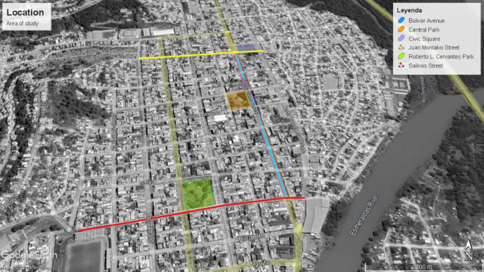
Delimitation of the Study Area Simón Bolívar Avenue is located in the urban area of the Esmeraldas parish of the city of Esmeraldas, and considered as an iconic road of the city and the most notable of the historic center, it is characterized by having a large influx of citizens, since it converges important institutions of public administra- tion and in addition, commercial activities are developed with a considerable influx of customers. For the development of the research, a 690-meter stretch of the study site has been estimated, which goes from Juan Montalvo Street to Salinas Street (see Figure 1).
Pedestrian Corridor for the Integration of the Administrative, Financial 125
Figure 1: Location of the study area, Simón Bolívar Avenue (Source: Google Earth, 2022).
Study Methodology The type of research used was mixed, being the quantitative and qualita- tive methods those used in the present study; in the beginning the research was exploratory since it served to know the problems of ambient noise, vehicle capacity, as well as those that correspond to the espacio and urban image; then becomes descriptive, since data collection was needed to measure the community’s perception of pedestrianization, problems at the study site, vehicle capacity and the level of ambient noise.
The implementation of the field research was carried out under the follo- wing aspects: 1. Observation and analysis of public space; 2. Data collection based on the opinion of the owners or dependents of commercial premises (surveys) and a representative of the municipal administration (interview); 3. Analysis of vehicular congestion; and 4. Analysis of the ambient noise. The observation and analysis of public space (observation fichas) was car- ried out on January 7, 2022 in 7 sections that cover a length of 690 meters of Bolívar Avenue (see figure 1): Tramo 1 that goes from Juan Montalvo Street to Rocafuerte Street, Section 2 from Rocafuerte Street to 10 de Agosto Street, Tramo 3 from Calle 10 de Agosto to Calle 9 de Octubre, Tramo 4 from Calle 9 de Octubre to Calle Piedrahita, Tramo 5 from Calle Piedrahita to Calle M. Cañizares, Tramo 6 from Calle M. Cañizares to Calle Mejía, and Tramo 7 from Mejía Street to Salinas.
Subsequently, a perception survey was carried out to the owners or mana- gers of 62 commercial premises, using a systematic probabilistic sampling with adjustment to finite population (every two premises), being the sample number 47, confidence level = 95%, margin of error = ± 5 (n = N Z2 pq / d 2 (N - 1) + Z2 pq). The survey was structured with five closed questions refer- ring to: the perception about the concept of pedestrianization, considerations about the problems that occur in Bolívar Avenue and the aspects that disfavor
126 Nevárez and Indaburo
its image; factors that can help improve the spatial image of the street and the opinion regarding the acceptance of the pedestrianization of the avenue.
The semi-structured interview was addressed to the Director of Planning of the Municipality of Esmeraldas, through which it was possible to know the opinion on the approach of a pedestrian corridor on Simón Bolívar Avenue; the processing of information from the interview was using the method of systematic analysis.1 For the calculation of the vehicle capacity, two points were considered for data collection: Point A, located in the Importadora Castro commercial house; and Point B located in the Almacenes TIA commercial house. In obtaining data on vehicle capacity, a descriptive cross-sectional study was used, recording the passage of vehicles for three days of the week (Mon- day, Wednesday and Friday) in three time periods: from 08h00 to 10h00, from 12h00 to 14h00 and from 16h00 to 18h00; each a time interval of 10 minutes.
Environmental noise: Data collection was carried out at the same points determined to obtain vehicle capacity data, using a descriptive cross-sectional method, simple random sampling; making the data collection on February 18, 2022 2in three time periods with intervals of 5 minutes: from 08h00 to 10h00, from 12h00 to 13h45, and from 16h00 to 17h45.
RESULTS AND DISCUSSION
Space and Urban Image The results obtained through observation sheets (see table 1) assessed the state of the sidewalks and their width, as well as the state of ramps that allow accessibility for people with reduced mobility; the existence of urban furniture and its condition; the presence and species of urban trees; invasive elements of the environment or urban image; and the signage of both vehi- cular and pedestrian traffic, as well as that corresponding to evacuation in cases of natural disasters. It was observed that the sidewalks are not in good condition and some have deterioration in the curbs, a large number of raised pavers and recurrent subsidence in the pavement were evidenced; the ave- rage width of the sidewalks meets the parameters established for pedestrian circulation, but they have been invaded by the presence of informal merch- ants who occupy these spaces. The ramps accessible to people with reduced mobility meet the required slope, however, they present failures in the rolling surface. As for the street furniture, there are 19 metal benches and few gar- bage cans (6) and due to their state some need maintenance and others must be replaced. There are about 18 trees of species ficus benjamina whose height ranges between 3m and 4m in height, the state of most of this urban trees is regular, but some of them are without the foliage, so it requires attention to improve its condition. In addition, it should be mentioned that no signage of evacuation routes was observed that indicate the routes that should be taken
1Identify topics a analyze from the patterns of the answers given that allows get conclusions for each of them. 2according to observation on Fridays it is perceived one greater number of people and vehicular influx.
Pedestrian Corridor for the Integration of the Administrative, Financial 127
Table 1. Results obtained from the observation sheets (Source: own elaboration).
Table available in the original PDF paper.
to the meeting point in case of a natural disaster, this is important considering that Esmeraldas is a city with high vulnerability to earthquakes.
The results obtained from the survey determined that 45% of respondents relate pedestrianization as a concept in which pedestrians are favored with the use of public space, while 22% believe that pedestrianization is an urban tool used to improve the street. The main problems that arise at the study site and that were perceived by citizens through the surveys are: insecu- rity (30%), traffic congestion (26%),poor condition of sidewalks (14%),and environmental noise (15%). Regarding the impact on the urban image, 45% of respondents identified the poor aerial wiring as a factor that causes a bad appearance to the image of Bolivar Avenue, followed by 35% who conside- red that the presence of street vendors does not give a good image ; while 18% considered street furniture and trees in poor condition as a factor that damages the image of the street. Regarding the factors that can help improve the image of Bolivar Avenue, 33.70% of respondents considered that burying aerial wiring can help improve the image of the avenue, while on the 24th. 72% mentioned that the improvement of sidewalks would favor to give a better appearance to the street. Finally, 55% of respondents indicated that they were in favor of a proposal to create a pedestrian corridor on a stretch of Bolivar Avenue, compared to 26% who did not agree with pedestrianiza- tion. Mediante interview conducted to Arch. Palacios, Director of Planning of the Municipality of Esmeraldas, considered pedestrianization feasible, but partially, that is, that vehicular traffic is not restricted in its entirety.
Vehicle Capacity The data obtained from the analysis of vehicle capacity on Simón Bolívar Avenue during the days Monday, Wednesday and Friday of the week of January 17 to 21, 2022 during a period of time of 6 hours in three periods
128 Nevárez and Indaburo
(8h00-10h00, 12h00-14h00 and 16h00-18h00), determined that 11553 cars circulated through point A, while 13736 vehicles passed through point B.
Ambient Noise The results obtained on the environmental noise that were recorded in the study area fluctuate between 58. 83 dB and 98. 50dB, and the hours in which these decibels were recorded correspond to a schedule that goes from 12h00 to 13h00. These values exceed the range allowed by the Municipal Orde- nanza 035 GADMCE, 3in which it indicates that 55dB is the permissible value in a mixed residential area, land use that corresponds to the study site.
CONCLUSION
Through the analysis of the results, it can be concluded that pedestrianization is a preponderant factor in the recovery of public space for pedestrians, the improvement of the urban image, the reduction of vehicular traffic and the reduction of environmental noise; That is why through the surveys it was possible to determine that the majority of the respondents agree with the pedestrianization of Simón Bolívar Avenue, considering this concept a como an urban tool with which pedestrians are favored.
The proposal to create a pedestrian corridor on Simón Bolívar Avenue through which the administrative, financial and commercial sector can be integrated will improve road safety and pedestrian mobility, as well as help reduce environmental noise and CO2 pollution produced by cars, that is, it will improve the quality of life of citizens, as well as have a favorable impact on local commerce.
REFERENCES
Castro, B. (2018) ‘5 Benefits That Pedestrianization Will Bring to Your City’, Moviliblog, p. 1. Available at: https://blogs.iadb.org/transporte/es/5-beneficios-que-la- peatonalizacion-traera-a-tu-ciudad/. Daher, C. (2017) ‘Do cities belong to cars or people?’, Planeta Futuro, El País,
22 September. Available at: https://elpais.com/elpais/2017/09/21/planeta_futuro /1506005016_230979.html. Dziekonsky, M. et al. (2015) ‘Public spaces and quality of life: Interdisci- plinary considerations’, Austral Journal of Social Sciences, (28), pp. 29–46. doi: 10.4206/racs.2015.n28-02. GADM Cuenca (2015) Plan de movilidad y Espacios de Cuenca, Ilustre Municipalidad de Cuenca. Gehl, J. (2006) The humanization of urban space. 5th., Editorial Reverté. 5th.
Barcelona, Spain. Available at: https://s3.amazonaws.com/academia.edu.docum ents/32232131/Correa_Espaco_Urbano.pdf?response-content-disposition=inline %3Bfilename%3DO_O_E_ES_SP_PA_AC_CO_O_U_UR_RB_BA_AN_NO.pd f&X-Amz-Algorithm=AWS4-HMAC-SHA256&X-Amz-Credential=AKIAIWO WYYGZ2Y53UL3A%2F201911.
3Ordinance to control environmental pollution caused by the emission of noise in the canton Esmeraldas.
Pedestrian Corridor for the Integration of the Administrative, Financial 129
Ortega-García, C. (2015) ‘Peatonalización de la calle Madero del centro histórico de la ciudad México’, UPCommons, p. 16. Available at: https://upcommons.upc.ed u/bitstream/handle/2117/81110/85MVD_OrtegaGarcíaClara.pdf. Ospina-Tascón, J. J. (2014) ‘Las Ramblas en el crecimiento urbano de Barcelona’,
Arquitectura y Urbanismo, XXXV(1), pp. 22–34. Available at: http://scielo.sld.c u/scielo.php?script=sci_arttext&pid=S1815-58982014000100003&lang=pt. Wallace, L. and Zaugg, S. (2019) Navigating Main Streets as Places. Available at: https://www.pps.org/product/navigating-main-streets-as-places-a-people-first -transportation-toolkit.
Read this individual research paper free through the original publisher, or explore the full digital proceedings book.
ISBN 978-1-958651-44-5
Explore this ISBN in the AHFE Bookstore ↗Listed in the July 2026 bookstore catalogue; search by ISBN to confirm current availability · Digital book purchase optional