Lisse Llerena Sandoya, Gabriela Vega (2022). Partial plan for the environmental conservation and historical and tourist development of the Peñón del Río hill, Durán, 2022. In: Human Interaction & Emerging Technologies (IHIET 2022): Artificial Intelligence & Future Applications. AHFE Open Access, vol. 68, pp. 77–83. https://doi.org/10.54941/ahfe1002715
In the north of the Durán canton, is located the hill called "Peñón del Rio", a natural elevation suitable for the development of agricultural and livestock activities, surrounded by rivers and streams that also harbor a dense amount of vegetative species. Archeological remains such as ceramics and burial pits from different cultures of the area were also found. The dry forest is one of the most threatened ecosystems and it is estimated that between 60% and 75% of it has disappeared. On the other hand, the sector is being seriously affected by the extraction of stone material, causing great damage to its ecosystem, to this is added the psychological and health damages caused by the noise, the trembling caused by the implosions executed, and the cloud of dust raised by the passage of heavy machinery; and finally, the high crime rate by which it is affected due to its abandonment. The purpose of this study is to develop a partial plan proposal, in which environmental and arqueological conservation areas of this natural elevation are determined to promote the preservation of the native flora avoiding the loss of identity of the vegetation, as well as the historical importance of the area, potentiating its tourist value, for which, through the observation technique and the handling of field cards, the identification of the plant species of the sector and the diagnosis of the affectation by the excavation of the stone material were carried out. In addition, georeferenced information on the trails and rest areas was collected with the help of Geographic Information Systems. To complement the study, qualitative research instruments were used to determine strategies for the conservation of green areas and the archaeological importance of the hill. As a result, a proposal was made for the location of walking trails, viewpoints and other rest areas, establishing their conservation and reforestation areas. In conclusion, the observed findings show historical roots of the Durán canton and even pre-Hispanic roots at the Latin American level, and the design of trails and rest areas, potentiate the tourist value of this natural elevation.
value, however, in the territorial development, the hills have remained as excluded spaces. The city has not been able to fully incorporate them as part of it, and they have become abandoned places, giving rise to spaces for informal uses such as land extraction or the settlement of irregular dwel- lings, which contributes to the destruction of their own natural and cultural heritage. Also, dry forests, generally located in relatively populated areas, are often located on soils suitable for crops and have therefore been heavily intervened and destroyed much more than rainforests (Aguirre et al., 2006), which is why, the dry forest is one of the most threatened ecosystems. In Ecu- ador, the dry forest represents approximately 10 % (25 030 km2) of the total surface and it is estimated that between 60 and 75 % of it has disappeared (Sierra et al., 1999). In consequence, it is necessary to create partial plans that allow the conservation of these critical areas within the territorial planning of a city. The Organic Law of Land Use and Land Management establishes that the purpose of partial plans is the detailed urban and land management regulation for the polygons of territorial intervention in urban land and in rural land of urban expansion.
METHODOLOGY
The study approach is based on a qualitative and quantitative perspective, and the type of research to be used for the development of the proposed topic is an exploratory model due to the use of observation techniques for the identification of species and bibliographic review; and descriptive for the analysis of the site by means of satellite images.
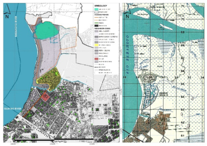
The Penon of the Rio Hill, an Elevation of History and Forest The Penon of the Río hill is located in the urban area of the Durán canton, on the border with the rural area, between the “El Hospital” stream to the north and the “Las Alforjas” stream to the south, with a height of 65 meters, according to the Topographic Chart at a scale of 1:50,000 published in the Public Geoportal of the Military Geographic Institute (IGM), which was pre- pared in 1989. From Nicolas Lapentti Avenue, it is located 5.28 kilometers following the route of Samuel Cisneros Avenue (Figure 1).
Proposal for a Partial Plan for the Environmental Conservation and Historical 79
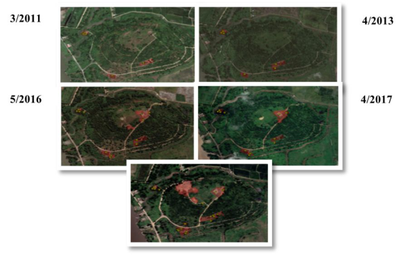
Figure 2: Analysis of interventions carried out 2011–2021.
Within the study sector, Italian archaeologists in association with the Faculty of Archaeology of the Superior Polytechnic School, found ceramic findings and burial pits, from cultures such as the Daular, the Manteño- Huancavilca and the Chonos, showing historical roots of the Durán canton and even pre-Hispanic at the Latin American level. This investigation gave way to the request to the National Institute of Patrimony, so that this area and mainly its hill, be declared a patrimonial zone of archaeological reserve (Domínguez, 1990), however, that until today, did not have any response. From the review of the different development and Land Management Plans of the Durán canton, this area has been destined for different uses. For the 2011–2015 period, the use was entirely residential. In the 2015–2019 period, this area was designated as a Strategic Protection Area, which correspon- ded to one of the strategic objectives which stated “To take advantage of natural resources in a sustainable manner within the framework of natural systems with a focus on reducing vulnerabilities to natural hazards”, ano- ther for equipment, surrounded by a totally residential use area. However, it was during this period that the concrete reservoir was built, with a capacity to store 6,000 cubic meters of water. While the period 2019–2023, the uses assigned to this natural elevation are shared between a strategic protection area. Furthermore, the “Peñón del Río” hill is home to a dense amount of native vegetative species of dry forest, which is one of the most threatened ecosystems. This is clearly verified in the satellite images of the free access software Google Earth Pro. As can be seen in the images in Figure 2, from 2011 to 2021 (10 years later) the number of buildings has increased from 5 to 21 respectively, and the intervened area from 1.11 hectares to 6.24 hectares, with the year 2021 being the year of greatest intervention.
Diagnosis of the Territory Based on Geographic Information Systems In territorial planning, Geographic Information Systems (GIS) play an impor- tant role in determining where things should be. In the first place, to achieve
80 Lisse and Gabriela
this, the state of the territory must be diagnosed; an activity that can be car- ried out more accurately if recent information is available and the changes that the territory has undergone over time can be known. An example of this is mapping and evaluating land cover change in cities (Pacheco, 2017). In environmental management, it is a tool used to evaluate natural resources; as it allows determining the location and quantification of deforested areas, impact on biodiversity and modification of hydrological processes, among other aspects (Trucíos et al., 2013). In addition, an updated orthophoto of the hill and the ARCGIS software were used to obtain data to help in the site analysis, with which the drawing of entities was made directly on the orth- ophoto and generating a geographic database with degraded areas, forest areas, human settlements, existing buildings, in addition to the proposed trails, viewpoints and rest areas. The orthophoto was taken using the Drone- Deploy application, where 75.56 hectares were covered, in two programmed flight plans, the first flight with an area of 39.54 hectares and the second covered the remaining 36.02 hectares, both flights at an altitude of 100.00 meters and a speed of 10m/s (36km/h).
Determination of Existing Species From the literature review, it is worth noting the “Guía dendrologica, Espe- cies Forestales Bosques Secos Ecuador, Ministerio del Ambiente, 2012”which describes the scientific and common names of the species, their characteri- stics and uses, as well as some recommendations for species identification. For species identification, three site inspections were carried out, each lasting approximately two hours. During the first inspection, several leaf specimens of trees and shrubs existing in the study sector were randomly collected, so that, considering the reviewed bibliography, a field card was made. This card contains 17 possible species that could be identified in the first inspection. The purpose of the second and third inspections was to obtain a final list of the existing species on the hill.
RESULTS
Archaeological Findings Archaeologically, the location was made up of multiple elements such as: a ceremonial tola five meters high, located towards the center of the hill and a series of twelve or more habitation mounds along the “El Hospital” stream, on the east side. It is a multicompetent site with a chronological sequence that goes from the Formative Period (Late Valdivia) to the Intera- ction Period. Also, around the site were found the pre-Columbian agricultural system for planting corn, beans and cassava. The site may have functioned as a commercial and ceremonial exchange center.
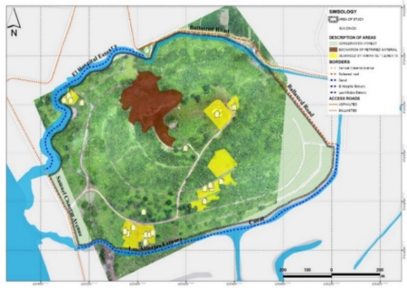
Analysis of Penon of the Rio Hill From the analysis of the orthophotos obtained, 4 characteristic zones of the sector were defined (Figure 3), which are mentioned in Table 1 with their respective surfaces that have allowed us to determine real data, such as the
Proposal for a Partial Plan for the Environmental Conservation and Historical 81
Table 1. Table of areas according to the analysis performed.
Table available in the original PDF paper.
Description Areas (Has) Conservation Forest Area 46,50 Area degraded by human settlements 4,25 Stone Material Extraction Area 4,10 Number of buildings constructed 24
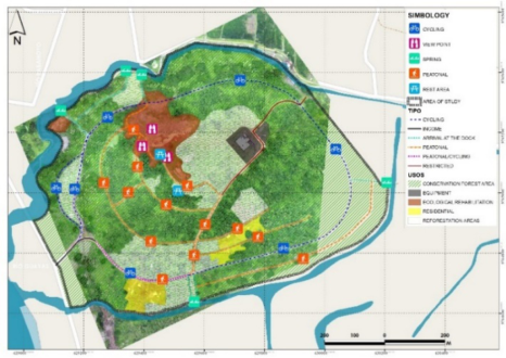
Figure 3: Analysis of Penon of the rio hill.Figure 4: Proposed partial plan for the penon of the rio hill.
area of the forest that is still preserved, which has not been affected by the extraction of petrous material, the area degraded by human settlements and the existing buildings.
Species Identified From the investigation in the field, 9 species detailed in table 2 were found. These will allow defining the endemic vegetation for its application in the proposal to be implemented.
82 Lisse and Gabriela
Table 2. Species identified.
Table available in the original PDF paper.
Ecosystem Services (Sierra et al., 1999)
N° Common Name
Science Name
1 Palo de ajo Gallesia integrifolia
The wood is soft and is used to make fruit crates.
The wood is used in carpentry, construction and firewood. It is a potential plant for ornamentation of parks and gardens. 2 Palo santo Bursera graveolens (Kunth)
3 Motuto macho
Tecoma Stans The wood is hard, it is used for posts, tool ropes and firewood. It has ornamental use. 4 Bototillo Cochlospermun vitifolium
The wood is soft, it is used to make fruit crates. 5 Algarrobo Prosopis juliflora (Sw.) DC.
The wood is used for posts, carpentry, parquet, firewood and charcoal. It is a species suitable for agroforestry systems (SAFs) and reforestation. 6 Guayacan Tabebuia chrysantha (jacq.)
The wood is soft, and is used for firewood, drawers and handicrafts.
Eriotheca ruisii schuman
The wood is used for cabinetmaking, furniture, parquet, structures and rural constructions. 7 Chirigua, chirigoyo, pasayo, jaile
Leucaena trichodes
Used for firewood. Species suitable for reforestation of slopes.
8 Ramón, chalú, pela caballo
9 Guarango Acacia macracantha
The wood is used to make parquet, charcoal, firewood, poles.
Partial Plan Proposal In the Partial Plan proposal, the following uses were determined:
Forest conservation area with 46.50 hectares with prohibition of comme- rcial, industrial, equipment and recreational activities.
Reforestation area with 11, 85 hectares, which will potentially use the species Tabebuia chrysantha (jacq.) (Guayacan), for its flowering, which becomes a tourist attraction, and the carob Prosopis pallida known as a “multipurpose tree”that helps protect watersheds and soil against erosion and degradation.
The trails cover a distance of 7.78 kilometers, whose road rights of way were established as defined on the site. The trails, which will be for wal- king, consist of a section of 8.00 to 11.00 meters. A circuit is proposed for cycling with trails of 9.50 to 12.00 meters wide and finally routes that lead to docks where recreational aquatic activities can be developed taking advantage of the location of the estuaries surrounding the hill, for this, the state of them must be diagnosed and strategies for their conservation must be established. It should be noted that the trails should have signage that
Proposal for a Partial Plan for the Environmental Conservation and Historical 83
will reflect the character of the place and respect its natural conditions in order to promote tourism development in the canton.
An area of 1.03 hectares was preserved for equipment, due to the operation of the drinking water reservoir tank.
The area affected by open-pit mining was defined as an Ecological Reha- bilitation Area, due to the degree of deterioration of the ecosystem. This area should be delimited with a living fence in such a way as to prohibit the passage of visitors.
CONCLUSION
The hill denominated Penon del Río, according to the investigations carried out, probably functioned as a place of commercial and religious activities which contains the archaeological remains of tolas and habitation mounds related to the Formative Period (Late Valdivia) up to the interaction Period, of the Daular, Manteño-Huancavilca and Chonos cultures.
It presently hosts an area of 46.50 hectares of native dry forest species, and through the reforestation area, an additional 296.25 species could be recovered.
The reforestation of the site with Guayacanes and the recreational and sports activities proposed in the Partial Plan enhances the tourist value and promotes its environmental conservation.
REFERENCES
Aguirre Z. 2012. Especies forestales de los bosques secos del Ecuador. Guía dendrológica para su identificación y caracterización. Proyecto Manejo Forestal Sostenible ante el Cambio Climático. MAE/FAO - Finlandia. Quito, Ecuador. p. 130 Aguirre, Z., Kvist, L. P., & Sánchez, & O. (2006). Bosques secos en Ecuador y su
diversidad. Dominguez S. (1986). Analisis Cerámico de la cultura Milagro recuperado de un contexto cerrado en el sitio arqueologico Peñón del Río. Drones en espacios urbanos: Caso de estudio en parques, jardines y patrimonio edi-
ficado de Cuenca. (n.d.). Available in: http://scielo.senescyt.gob.ec/scielo.php?scri pt=sci_arttext&pid=S1390-92742017000200218&lang=es Jiménez J., y Cabrera G. (2020). Del Cerro a la Ría: “Durán, un recorrido Histórico.”
Digráfica S.A. Trucíos R., Rivera M., Delgado G., Estrada J. y Cerano J. (2013). Análisis sobre cambio de uso de suelo en dos escalas de trabajo. Terra Latinoamericana, 31(4), 339–346. Available in: http://www.scielo.org.mx/scielo.php?script=sci_arttext& pid=S0187-57792013000500339&lng=es&tlng=es.
Read this individual research paper free through the original publisher, or explore the full digital proceedings book.
ISBN 978-1-958651-44-5
Explore this ISBN in the AHFE Bookstore ↗Listed in the July 2026 bookstore catalogue; search by ISBN to confirm current availability · Digital book purchase optional