Yu Liu, Peter Hasdell (2022). Sustainable Urban Delta: The Inspiration to PRD through the Comparative Analysis of Netherlands Reclamation History. In: Human Factors in Architecture, Sustainable Urban Planning and Infrastructure. AHFE Open Access, vol. 58, pp. 247–253. https://doi.org/10.54941/ahfe1002358
Due to the significant demand for land resources and rapid urbanization, reclamation has become one of the essential choices for developing coastal cities. However, the intensive reclamation projects lead to the high vulnerability of the delta. Attention to the general discussion of ecological security, vulnerability, and sustainability has proliferated in recent years, but insufficient attention has been paid to a detailed explanation of the specific human activities' impact on the overall delta from a narrative historical aspect. In this article, the Deltas of Netherlands and Pearl River Delta (PRD) in multiple scales are selected as cases. The two deltas share similarities in geography, physical system description, ecological system, management Issues, and human activities. The comparative analysis offers a means to improve the understanding of mechanisms for addressing ecological vulnerability by comparing two deltas in social and environmental aspects.The analysis section elaborates the similar reclamation history of two deltas by the sequence of three stages. By comparing the diverse responses of respective projects in macroscale and microscale with similar morphological and ecological features, it is effortless to improve the understanding of reactive mechanisms of systems, which directly affect the vulnerability index. The Vulnerability index will also be listed and elaborated corresponding to the historical stages. Moreover, successful examples of the Netherlands show the advanced experiments in guild thinking, governance, strategies. Thus, the comparative analysis provides comprehensive syntheses, mechanistic insights, and feasible alternatives to PRD. And beneficial guidance to develop a sustainable urban delta could be proposed.
Due to the significant demand for land resources and rapid urbanization, reclamation has become one of the essential choices for developing coastal cities. In recent years, the rapid economic development of PRD gives factors to the scale of reclamation projects and the expansive artificial coasts (Wu, W. et al., 2016). Although the PRD has shown rapid development and potential
in the past few decades, the intensive implementation of the reclamation projects destroyed the ecological environment, vegetation, and original delta landform and topology, which led to enormous environmental challenges and threats, including floods, ecological degradation, soil subsidence, erosion, etc. (Gu, C. et al., 2011; Schmidt, C. W., 2015).
China is not the only case of reclamation. The most successful example of the world’s land reclamation is the Netherlands. However, in the 1960s, Netherlands’ people realized that the negative impact of the reclamation in the environmental aspect had been neglected. Thus, the council has reco- nciled the projects (the delta project, the Wadden Lake, etc.) and ultimately suspended relative reclamation projects (Wolff 1992), while the land recla- mation projects in PRD are still being carried out to expand real estate and industrialized land in coastal areas until now (Feng, T., & Xu, N., 2021).
Attention to the general discussion of ecological security, vulnerability, and sustainability has proliferated in recent years, but attention to a detail expla- nation of relationship between the vulnerability index and human activities on the overall delta from a narrative perspective is insufficient.
THE COMPARATIVE ANALYSIS The Significance of Comparing PRD and Netherlands
In this article, the Deltas of Netherlands and Pearl River Delta (PRD) in mul- tiple scales are selected as cases. The Netherlands is located in the delta of the Rhine and the Meuse rivers, and the PRD is the delta of the Pearl River.
Both regions were extensive intertidal flats with ecologically valuable flora and fauna. Both construct multi-channel water systems to improve and maintain navigation (Li, B., & Van Zanden, J. L., 2012) and select similar activities, such as reclamation, to develop the real estate and industrial area. Before the great divergence (19th century), China and Europe were quite similar in economic aspects (Li, B., & Van Zanden, J. L., 2012).
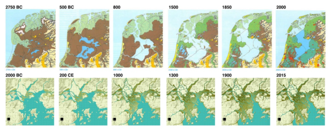
The Chronological Evolution of the Landscapes This article will be divided the reclamation history into three stages as a fra- mework (Cao, W. & He, Q., 2019) to illustrate the sequences of landscape evolution individually:
The first stage features are extensive minor reclamation with the main functions of agricultural reclamation and water conservancy diversion.
The embankment in the local communities started first to create interior and the reclamation followed. The oldest embankment of the Netherlands, PRD, started in 11 centuries and 960AD. The tradition of reclamation could be traced back to about 960BC in PRD (Weng, Q., 2007) and the reclamation on interior land in the Netherlands started about 11 centuries.
The reclamation process defined the extremely exquisite and highly main- tained artificial construction and landscape in both areas. After the emban- kment establishment, thousands of km2 of moor and wetlands have been reclaimed by the workforce (Hoeksema, R. J., 2007). The advanced win- dmill and the steam-powered water mill for pumping water fostered the
Sustainable Urban Delta: The Inspiration to PRD through the Comparative Analysis 249
Figure 1: The evolutionary series map of PRD and Netherlands. (Edited by authors, Netherlands map source: https://www.agendaijsselmeergebied2050.nl/achtergrondin formatie/cultuurhistorie; PRD’s source: Xiong, L. (2020). Pearl River Delta: Scales, Times, Domains).
progress of reclamation projects respectively since the mid 16th century and in 1787 (De Mulder et al., 2019; Wolff, 1992;). Over 6000 km2 or about 10% of the present Dutch territory were thus reclaimed (Hoeksema, R. J. 2007; Wolf, 1992). From mid 14 century (Ming dynasty) to 1979, the local government continued reclamation seawards to expand agricultural land. (Weng, Q., 2007; Chunshan L. et al., 2017). Over 1700 km2 (1368-1644, 666km2 ; 1644-1911, 866km2; 1950-1979, 140km2) (Weng, Q., 2007) delta were reclaimed with the less than average 5 km2 per year.
The features of the second stage are the intensive reclamation activities that will be carried out to develop into a compacted urban area with multi- ple functions, such as industrial areas, transportation, urban expansion, etc. (Cao, W.& He, Q., 2019).
The reclamation process by multiple approaches and techniques facilitates and accelerates compacted cities with multiple function in both areas. In the 19th century, steam engines and subsequent diesel and electric engines were used to pump water which enabled the large-scale traditional reclamation (such as Haarlemmermeer and Zuiderzeeplders) until the former half of the 20th century. However, the Zuiderzee (1918) project and the Delta project completely dominate the last the centuries. The embankment and reclamation of wetlands also culminated in the 20th century. Over 1,650 km2 or about 4% of the present Dutch territory were thus reclaimed in the 20th century (Hoeksema, R. J., 2007). In PRD, from the mid-1980s, with the dike pond systems were rapidly popularized and replaced part of the agricultural land, The reclamation projects became even more intensive with the peak rate of more than 100 km2 annual (Li et al., 2012). Since 2000, with rapid indu- strialization and metropolization, the compacted urban delta has developed toward the sea rapidly by reclamation, with the function transformed from agriculture and fishery to industry, transportation, and urban construction (Chunshan L. et al., 2017). Over 620 km2 were reclaimed since 1980 with the rate of more than 17 km2 annual, and about 157km2 were non-agricultural construction (Chunshan L. et al., 2017).
250 Liu and Hasdell
The features of the third stage are the restriction of land reclamation activities based on the priority of environmental protection.
Since the 1960s, opposition to the reclamation gradually mounted and finally resulted in revise and the abandonment of several other projects in Netherlands, while the reclamation projects along the coast are continuing to give the economic and political factors (Feng, T., & Xu, N., 2021; Wu, W. et al., 2016). In the 1960s, conservationists doubted the economic and ecolo- gical feasibility of the Wadden Sea and provoked the awareness of protecting natural resources. Hence the government admitted the reclamation was not justified and suspended the project. So as the delta project. Afterward, the disapprovals to the other two new reclamation projects assumed any further reclamations for any purposes will be considered seriously or even unlikely to happen in the future. (Wolff, 1992) In PRD, although the management of the marine area and reclamation in PRD has increasingly strict, and the opposition to reclamation have also been increasing since 2000 (Chunshan L. et al., 2017).
VULNERABILITY INDEX The coastal ecosystems, namely the tidal flats and wetlands, are ideal balance formed by the interaction between the ocean and the land for millions of years. They function as the barrier protecting nearby landscapes, offshore creatures, coastal cities, and communities from extreme weather and natural disasters (Arkema, K. K et al., 2013).
However, coastal development, which evitable included intensive recla- mation and embarkation, shoreline artificialization, etc., led to the massive encroachment of the coastal buffer zone (Chunshan L. et al., 2017). Thus, the loss of the coastal ecosystems increases the vulnerability and restricts the economic and social development of sustainable urban delta. The main challenges and threats related to the stages show as follows: Flooding
The embankment is the local communities’ response to the frequent floo- ding (Weng, Q., 2007). However, the subsequent intensive embankments and reclamation projects, especially in stage two, changed the shape of the riverbeds and promoted the extension of the delta to the sea.
Thus, the frequency of floods has increased sharply because of the inten- sive and extensive embankment and reclamation projects. For example, In PRD, the data derived from di fang zhi showed an increasing trend of flood frequency (Chunshan L. et al., 2017). Nine floods were recorded in the Song dynasty, yielding a frequency of one flooding per 36 years since 960. The flood frequency drastically increased to every six years since 1279, every two years since 1368, and to every other year (Zhujiang Delta Agricultural History Committee (ZAHC), 1976) around 20 centuries in the first stage. Since 1949 there has been flooding every year.
Ecological Degradation The coastal ecosystems, with diverse wetlands, provide significant ecolo- gical services. The delta of the Netherlands and PRD are both significant
Sustainable Urban Delta: The Inspiration to PRD through the Comparative Analysis 251
ecosystems by the Ramsar Convention. The West Scheldt estuary is also desi- gnated as the Natura 2000 because of the existing valuable creatures and unique wetlands.
However, reclamation leads to ecological degradation. The reclamation and embankment projects in the stage one and two are the primary drivers to directly lose wetlands, resulting in a 16% loss of coastal tidal flats glo- bally from 1984 to 2016. For PRD, from 2002 to 2007, the rate of wetland disappearance increased from 20 km2 per year to 134 km2 per year. Reclama- tion and embankment projects have also indirectly negatively impacted local wetland ecosystems through soil compaction, heavy metal contamination, and water quality transition.
Soil Subsidence Many large deltas in coastal regions undergo rapid land subsidence with population and economic growth (Wang, H. et al., 2012). The soil subsi- dence in delta areas results from both natural factors and anthropogenic interference (Li, G. et al., 2020). However, the influence of anthropogenic interference even exceeds that of natural factors, especially for the recent 100 years. The interference includes a series of human activities, such as groun- dwater extraction, reclamation, and engineering construction (Chen et al. 2012). Anthropogenic interference associated with the intensive reclamation in stage two extends the subsiding area and increases the subsiding rate. (Li, G. et al., 2020) For example, the subsidence rates of the urbanization of Shen- zhen, particularly at Shijing and Fuyong, are average 2.5 mm annually. Land subsidence amplifies local relative sea-level rise and puts the affected popu- lation at greater risk of environmental problems such as flooding, shoreline erosion, and saltwater intrusion.
CONCLUSION
The urgent issue in PRD is the sharp decline of the delta area resulting from the intensive and extensive reclamation and embankment projects (Cao, W.& He, Q., 2019). The dying delta area increases the coastal vulnerability by exacerbating the environmental and ecological problems and weakening the protective ability of the buffer zone. By comparing with the Netherlands and PRD in China as a framework and summarizing the vulnerability index that highly related to the reclamation and embankment projects on stage two, the advanced experience of Netherlands is potential to be learned, adapted, and apply in the PRD by comparing the two area from the narrative perspective. The inspiration are as follows: Nature Reservation
Awareness of protecting the natural sources, such as wetlands, is also the reason for the opposition to the Wadden Sea and delta project of the Netherlands. However, PRD has not yet entered the third stage, and the reclamation projects are still in progress.
252 Liu and Hasdell
Thus, stopping reclamation and strengthening protection for the rese- rvation and conservation of the natural resources will be a prerequisite to resolve the related vulnerability indexes. For example, the renowned Room for the River program (2012-2016) in the Netherlands enabled the rivers to discharge far greater volumes of water safely based on the environmental consideration. By creating water buffers, relocating levees, and construction of flood bypasses, the designers return the agricultural land to the reservation function.
Collaborations and Governance between the Interdisciplinary and Agendas The collaborations and governance between the interdisciplinary and agen- das ensure the scientific governance, effective management based on the priority of environmental protection and to promote temporal and spatial coordination of integrated coastal management.
Compare with China, the local governments and local communities led by elites, mainly the “gentry” (Li, B., & Van Zanden, J. L., 2012), in the Netherlands, institutions across the Arachis and the individual stakeholders especially on stage three are responsible for the planning, policymaking, and water management, which showed mass reduction vulnerability index and disaster.
Cases also showed the possibility of the close collaborations and governa- nce. For instance, Room for river shows a successful example with 39 projects across the country (Rijke et al., 2012) with the close collaborations in gover- nance among stakeholders, provinces, municipalities, water authorities, and the central government.
Adapted Nature-Based Solutions or Eco-Engineering Projects Many emerging architecture, urban planning, and landscape architecture in the Netherlands showed the protective attitude based on the adapted nature- based solutions and eco-engineering. The original constructing concept on the stage one in Netherlands, such as living with water, was rooted in the traditional projects of the Netherlands. For one thousand years, Nether- lands’s people turned lakes, marshland into arable terrain with accessible water transportation by reclamation. However, for the last decades, the Netherlands shifted the defensive and controlled attitude towards water and nature, and has begun to consider the environmental side. Some more resi- lience concepts such as ‘building with nature’ or ‘working with nature’ go beyond the civil engineering projects, and adapted nature-based solutions or eco-engineering (Janssen, S. K. et al., 2014) to guild the projects and provide protection against flooding and coastal erosion, and opportunities for nature and recreation.
The system enables the landscape to grow with nature and adapt the nature process/diseases to turn in the force to build a landscape, which reshape the relationship between the nature and technical world. For instance, the Marker Wadden Island project, Netherlands, was being built by the natural dynamic processes (wind, waves, currents, water level, and ice tilt) which
Sustainable Urban Delta: The Inspiration to PRD through the Comparative Analysis 253
were originally regarded as resistance. Fluctuation of water level will cause additional water flow into the swamp, thereby promoting natural proces- ses such as erosion and sedimentation, thereby further shaping the local landscape.
REFERENCES
Arkema, K. K., Guannel, G., Verutes, G., Wood, S. A., Guerry, A., Ruckelshaus, M., ... & Silver, J. M. (2013). Coastal habitats shield people and property from sea-level rise and storms. Nature climate change, 3(10), 913–918. Cao, W., He, Q. (2019). Ecological Security Management and Planning of Coastal
Zone Under the Impact of Reclamation. Planner, 35(7), 25–32. Chen, S. S., Chen, L. F., Liu, Q. H., Li, X., & Tan, Q. (2005). Remote sensing and GIS-based integrated analysis of coastal changes and their environmental impacts in Lingding Bay, Pearl River Estuary, South China. Ocean & coastal management, 48(1), 65–83. Chunshan Liu, Tonghui Zhang, & Weizhe Chen. (2017). Analysis and Progress of
Sea Reclamation in the Pearl River Delta珠江口海域围填海演进过程与问题分析 研究. Ocean Development and Management, 34(3), 33–37. De Mulder, E. F., De Pater, B. C., Fortuijn, J. C. D., De Klerk, L., & Van Dijk, J. (2019). The Netherlands and the Dutch: A physical and human geography. Springer International Publishing. Feng, T., & Xu, N. (2021). Satellite-Based Monitoring of Annual Coastal Reclama-
tion in Shenzhen and Hong Kong since the 21st Century: A Comparative Study. Journal of Marine Science and Engineering, 9(1), 48. Gu, C., Hu, L., Zhang, X., Wang, X., & Guo, J. (2011). Climate change and urbanization in the Yangtze River Delta. Habitat International, 35(4), 544–552. Hoeksema, R. J. (2007). Three stages in the history of land reclamation in the Neth-
erlands. Irrigation and Drainage: The journal of the International Commission on Irrigation and Drainage, 56(S1), S113-S126. Janssen, S. K., Mol, A. P., Van Tatenhove, J. P., & Otter, H. S. (2014). The role of knowledge in greening flood protection. Lessons from the Dutch case study future Afsluitdijk. Ocean & Coastal Management, 95, 219–232. Li, B., & Van Zanden, J. L. (2012). Before the great divergence? Comparing the
Yangzi Delta and the Netherlands at the beginning of the nineteenth century. The Journal of Economic History, 72(4), 956–989. Li, G., Feng, G., Xiong, Z., Liu, Q., Xie, R., Zhu, X., ... & Du, Y. (2020). Surface deformation evolution in the Pearl River Delta between 2006 and 2011 derived from the ALOS1/PALSAR images. Earth, Planets and Space, 72(1), 1–14. Schmidt, C. W. (2015). Delta subsidence: an imminent threat to coastal populations. Weng, Q. (2007). A historical perspective of river basin management in the Pearl
River Delta of China. Journal of environmental management, 85(4), 1048–1062. Wu, W., Tian, B., Zhou, Y., Shu, M., Qi, X., & Xu, W. (2016). The trends of coastal reclamation in China in the past three decades. Acta Ecologica Sinica, 36(16), 5007–5016. Xiong, L. (2020). Pearl River Delta: Scales, Times, Domains: A Mapping Method for
the Exploration of Rapidly Urbanizing Deltas. A+ BE| Architecture and the Built Environment, (21), 1–218. Zhujiang Delta Agricultural History Committee (ZAHC), 1976. Agricultural Records of Zhujiang Delta. Foshan District Revolutionary Committee, Foshan (in Chinese).
LISTED IN THE AHFE DIGITAL BOOKSTORE CATALOGUE
Explore the complete digital volume
Human Factors in Architecture, Sustainable Urban Planning and Infrastructure
Read this individual research paper free through the original publisher, or explore the full digital proceedings book.
ISBN 978-1-958651-34-6
Explore this ISBN in the AHFE Bookstore ↗Listed in the July 2026 bookstore catalogue; search by ISBN to confirm current availability · Digital book purchase optional