Youssef Ibrahim, Christoph Weiß, Elisabeth Broneder (2026). Reliable Outdoor Localization for Mixed Reality Object Placement and User localization. In: Human-Computer Interaction & Emerging Technologies. AHFE Open Access, vol. 233, pp. 446–455. https://doi.org/10.54941/ahfe1007544
Mixed reality in outdoor settings requires localization systems capable of maintaining stable spatial anchors, precise object positioning, and accurate user directionality despite the complexities of real-world conditions. Outdoor MR applications are limited by factors such as variable lighting conditions, terrain obstructions, moving objects, and inconsistent network connectivity. These factors directly affect the reliability of virtual projection andthe persistence of virtual content, and the user's ability to interact with MR elements in a meaningful and context-aware manner. The key challenge for creating usable outdoor Mixed Reality applications is ensuring that virtual objects accurately correspond with their physical counterparts. Our work focuses on enabling robust visualization of mixed reality objects, rather than prioritizing any single positioning technology. We have designed a localization pipeline that combines different technologies, specifically for use in outdoor MR environments, where the stability of the virtual content is more important than the raw GPS signal. The approach combines SLAM (Simultaneous Localization and Mapping) with GNSS data to provide both globally accurate positioning and locally stable tracking. SLAM provides continuous motion estimation and high-frequency orientation tracking necessary for rendering MR content without drift. At the same time, GNSS adds an absolute reference frame that keeps MR objects anchored to fixed points across large outdoor areas. This fusion allows MR systems to place, persist, and share virtual objects with significantly improved fidelity. Annotations, navigation indicators, and shared spatial references remain consistently aligned despite the user navigating complex outdoor environments. The improved orientation estimation ensures accurate representation of the user's viewing direction, thereby facilitating precise interaction with MR elements. Outdoor MR applications, including inspection workflows, field maintenance, security operations, and multi-user collaboration, benefit from consistent, reliable visual projections. This work shows a practical method for providing high-precision outdoor MR experiences by focusing on MR stability and only using multi-sensor fusion, when necessary, to compensate for the limitations of traditional tracking techniques.
Mixed Reality (MR) holds significant promise for enhancing user interaction with digital content by anchoring virtual elements to the physical world.
Reliable Outdoor Localization for Mixed Reality Object Placement and User Localization 447 While indoor MR systems have advanced reliably using visual features and controlled environments, outdoor MR systems encounter fundamentally different challenges (Azuma et al., 2015; Billinghurst et al., 2015). Variable lighting conditions, dynamic terrain occlusions, moving objects, and inconsistent connectivity complicate reliable localization (Reitmayr and Drummond, 2016; Zhu et al., 2020). As a result, persistent spatial anchors, precise object positioning, and accurate user orientation remain difficult to achieve in real-world outdoor settings (Langlotz et al., 2016).
Outdoor localization has traditionally relied on global navigation satellite systems (GNSS), such as GPS, for absolute positioning. However, GNSS is limited by signal latency, multipath interference, and environmental obstruction, yielding positioning inaccuracies that are unacceptable for MR overlay stability (≈ decimeterlevel or worse) in many outdoor scenarios (Zhu et al., 2020). Recent research in visual localization and Simultaneous Localization and Mapping (SLAM) has demonstrated the ability to provide continuous motion tracking and high-frequency orientation estimation capabilities that support smooth MR rendering and interaction (Reitmayr and Drummond, 2016). However, SLAM alone lacks an absolute reference frame and is vulnerable to drift over extended trajectories or under visual degradation, such as uniform terrain or featureless environments (Langlotz et al., 2016). Existing strategies for outdoor MR applications often address the problem by enhancing a single tracking modality or by hierarchical sensor usage (Schmalstieg and Höllerer, 2016). For example, vision-based mapping techniques have been tied to prebuilt 3D urban models to support location anchoring at scale, and machine learning methods have been employed to augment GNSS with map or image cues for improved localization consistency in Augmented Reality (AR) contexts (Reitmayr and Drummond, 2016; Zhu et al., 2020). Despite this progress, research for outdoor MR applications still lacks a comprehensive methodology that prioritizes MR-specific stability requirements over raw positioning performance. Persistent and stable hologram placement, consistent orientation estimation, and support for shared spatial references across multiple users are central to outdoor MR applications usability yet are not assured by systems optimizing raw accuracy alone. In this work, we argue that usable outdoor MR applications depends on a localization pipeline that emphasizes stable and persistent spatial behaviour rather than isolated performance of any single positioning technology. We design a localization framework tailored to the needs of outdoor MR applications, wherein different technologies are combined in ways that exploit their respective strengths—such as using highfrequency tracking for smooth orientation and global positioning signals for reference when available, without claiming a generalized technical fusion of their underlying algorithms. This approach ensures that virtual objects are placed, persist, and remain shareable across users even under conditions of environmental complexity, partial satellite reception loss, or visual obstruction.
We position our contributions around enabling outdoor MR applications where visual stability and contextual persistence are critical. Our pipeline supports robust hologram anchoring and improved orientation estimation that facilitates user interaction with MR elements. This framework is
demonstrated through two key projects: EnviPeace and Borderforce. EnviPeace is designed for training peace personnel in crisis situations and scenarios, employing outdoor localization to create realistic, context-aware training environments. Borderforce addresses border security and control, with our system supporting the security planning phase by providing precise outdoor localization for scenario planning and strategic decision-making.
Related Work
Research on outdoor Mixed Reality and Augmented Reality systems has largely focused on improving localization accuracy and robustness under real-world conditions. Early outdoor AR systems relied heavily on GNSS and inertial sensors, which enabled coarse alignment at large scales but failed to deliver the spatial precision and stability required for persistent virtual content (Foxlin, 2016; Weng et al., 2019). Even with modern GNSS improvements, multipath effects, satellite occlusion, and latency remain dominant sources of error in urban and semi-structured outdoor environments.
Vision-based localization, especially using SLAM, is now key for MR tracking because it can estimate movement and orientation smoothly and quickly. Modern visual-inertial SLAM works well for short-term stability (Pérez-Yus et al., 2017; Reitmayr and Drummond, 2016). However, these systems only track locally and can drift over time, especially outdoors where textures repeat or lighting changes. Because of this, SLAM alone cannot keep virtual objects anchored over long distances. Recent empirical evaluations of RTK-GNSS for wearable AR further confirm that satellite-based localization only reaches centimetre accuracy in open-sky conditions and degrades to metre-level errors near buildings and obstacles, limiting its usefulness for stable outdoor MR tracking in typical urban spaces (De Pace and Kaufmann, 2023) 1.1. Complementary work benchmarking commercial AR localization platforms shows that camera-based visual positioning (e.g., Immersal, Vuforia, MultiSet) can achieve decimetre-level outdoor accuracy, whereas geospatial APIs tied to GNSS exhibit errors of several metres and require hybrid designs that switch between indoor area targets and outdoor geospatial anchoring for campus-scale navigation (Skabek et al., 2025) Some studies have tried to improve outdoor localization by matching camera images to existing maps or 3D city models. This can help align virtual content and reduce drift in outdoor AR navigation (Langlotz et al., 2016; Zhu et al., 2020). However, these methods rely on having up-to-date and accurate maps, which is not always possible in changing environments. Recent work has also looked at combining different sensors, like using satellite images or landmarks, to help with global alignment or to start visual tracking (Shao et al., 2021; Kim et al., 2018). These approaches focus on making systems more robust, but they are often designed for navigation or mapping, not for keeping MR content stable and persistent.
Within the MR and AR domain, stability of virtual content has been increasingly recognized as a critical usability factor. Studies evaluating user expereince in outdoor AR applications highlight that even small positional or rotational inconsistencies significantly reduce user trust and task
Reliable Outdoor Localization for Mixed Reality Object Placement and User Localization 449 performance, particularly in applications involving annotations, navigation aids, or shared spatial references (Kruijff et al., 2016; Höllerer et al., 2019; Skarbez et al., 2017). Despite this, many localization approaches continue to optimize conventional metrics such as absolute position error rather than perceptual stability or anchor persistence.
Outdoor MR for multiple users is even more challenging because shared virtual content needs to stay aligned for everyone, even when their devices have different sensors. Many current systems use cloud anchors or shared maps to let users see the same content, but these can still drift or be affected by changing environments (Weng et al., 2019; Billinghurst et al., 2015). Keeping everything lined up for all users is still a problem that needs solving in outdoor MR.
In summary, prior work demonstrates that no single localization technology sufficiently satisfies the stability, persistence, and robustness demands of outdoor MR. GNSS provides global reference but lacks precision; visual tracking offers local stability but drifts over time; and map-based or auxiliary approaches introduce dependencies that limit general applicability. This paper builds on these insights by focusing explicitly on MR-centric stability, proposing a localization pipeline that combines complementary technologies at a system level to maintain reliable spatial behaviour in complex outdoor environments.
System Requirements for Outdoor MR Systems This section outlines the system requirements for an outdoor Mixed Reality (MR) system with a primary focus on robust localization and spatial alignment in real-world environments. The goal is to support stable placement and persistence of virtual content in outdoor settings by combining global positioning with reliable local tracking.
The system needs to use global localization to anchor MR experiences to real-world locations. GNSS data sets the user’s starting position in a geospatial frame, so MR content can be placed consistently and found again later. Meter-level accuracy is enough if the system keeps spatial relationships steady after setup. The system should convert geographic coordinates into its own format and provide fast, continuous local tracking to keep MR content stable. Local tracking must capture user movement and head direction accurately to avoid jitter or drift. Keeping orientation stable is especially important outdoors, as users need virtual content to stay aligned with the real world. After the initial setup, local tracking should take priority, even if global data becomes unreliable.
Virtual content placed within the MR environment must remain persistently anchored to its intended real-world location. Spatial anchors should not drift relative to the physical environment as the user moves.
Persistence is essential for outdoor MR use cases that involve revisiting locations, comparing spatial configurations, or maintaining situational awareness over time. The system must therefore preserve relative alignment throughout the session and ensure predictable behaviour under changing conditions. The system must operate reliably under typical outdoor
conditions, including variable lighting, dynamic surroundings, and intermittent GNSS availability. Temporary degradation in global positioning should not invalidate existing spatial anchors or disrupt local tracking. The system should degrade gracefully and recover automatically when external conditions improve, without requiring manual recalibration or user intervention.
Localization updates must occur at a rate sufficient to support real-time MR interaction. Latency between user motion and corresponding updates in virtual content placement should be minimized to preserve immersion and usability. Responsiveness is a key factor in user comfort and spatial understanding, particularly in outdoor environments where users are physically moving through space.
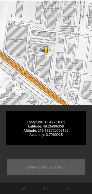
Implementation and Setup The system is implemented using the Magic Leap 2 (Magic Leap, 2026) mixed reality headset, which provides inside-out visual–inertial tracking (SLAM) for local pose and orientation estimation. To obtain global position information, the system relies on GNSS data from a mobile phone. The phone provides latitude, longitude, and altitude estimates, which are transmitted to the MR application. This setup reflects a practical deployment scenario, as the headset itself does not provide reliable outdoor global positioning.
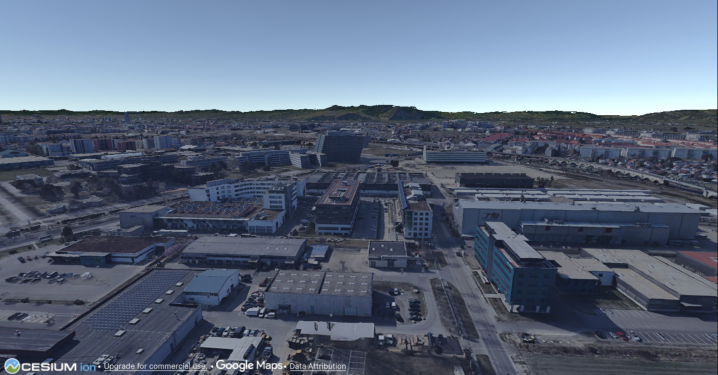
The application is developed in Unity3D (Unity Technologies, 2026), along with OpenXR (Khronos Group, 2026), enabling MR interaction and visualization. Unity allows integrating headset tracking data, external GNSS input, and spatial anchoring mechanisms within a single framework using multiple plugins and libraries in the project. One of the elements used within Unity3D is “Cesium (Cesium, 2026) for Unity”. Cesium is a geospatial platform that enables real-time visualization and streaming of massive 3D Earth data, such as terrain, imagery, and 3D buildings. In Unity, Cesium allows developers to place and interact with accurate, real-world geospatial content at a global scale inside real-time 3D applications. Cesium provides a geospatial reference model of the Earth. In this system, Cesium is used as an invisible spatial framework, defining real-world scale, orientation, and geographic consistency. Virtual content is positioned relative to this geospatial model, even though the map itself is not rendered at the start, but visualization can be changed with the click of a button. When the app starts, it converts GNSS coordinates from the phone into Cesium’s world coordinates. This sets the user’s starting position in a global frame, giving a rough alignment between the MR experience and the real world. After this, the system no longer needs constant GNSS updates, helping avoid problems caused by noisy or weak signals. The user is, however, able to adjust the orientation of the world using the headset controller. This is to align the world correctly towards the North direction, thus aligning virtual elements with real-world elements if the initial orientation is off.
After global initialization, the system primarily relies on Magic Leap 2’s local tracking to update the user’s pose and orientation. Local tracking provides smooth, low-latency updates that are essential for maintaining
Reliable Outdoor Localization for Mixed Reality Object Placement and User Localization 451 perceptual stability during movement. This integration strategy allows the system to benefit from the strengths of both positioning modalities: GNSS for global reference and SLAM-based tracking for local stability. Virtual content is anchored within the geospatial reference frame established at initialization. Once placed, anchors maintain their spatial relationship to the real world as the user moves. The system ensures that local tracking updates do not introduce drift in anchored content, preserving consistent alignment throughout the session. This approach supports repeatable and predictable behaviour, which is critical for outdoor MR localization tasks.
Figure 1: Cesium map.
The current system is designed to provide stable localization and consistent spatial alignment, rather than achieving centimeter-level accuracy or relying on tightly integrated sensors. By using external GNSS for the initial setup, there are some unavoidable accuracy limitations, particularly in areas with weak satellite signals and that have no 3D satellite imagery coverage. However, the system is specifically built to manage these limitations by prioritizing stability and predictability for the user. This project is still ongoing and will serve as a foundation for future improvements, such as enhanced global alignment or more robust performance in challenging outdoor environments.
RESULTS AND DISCUSSION
Initial outdoor testing verified that the system can initialize the user’s position using GNSS input and maintain stable local tracking during movement. Once initialized, virtual content remained spatially consistent relative to the physical environment, even when GNSS updates were intermittent or unavailable.
The separation between global initialization and local tracking proved effective in preserving perceptual stability. No abrupt jumps or reinitialization artifacts were observed during normal operation. However, inaccuracies in the initial GNSS estimate could lead to a persistent spatial offset, indicating
a limitation in absolute alignment that is inherent to the reliance on coarse global positioning.
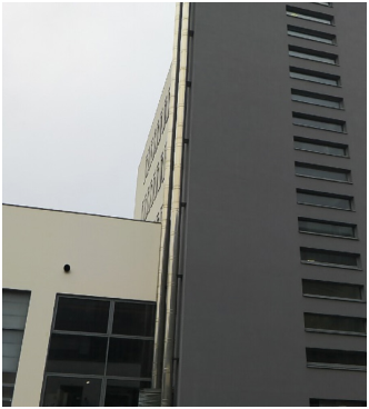
Figure 2: GPS app from android device.Figure 3: Left: Real-world as seen from MR glasses, Right: Cesium map world at the same position as seen from MR glasses.
Reliable Outdoor Localization for Mixed Reality Object Placement and User Localization 453 The current evaluation is limited by the absence of quantitative localization measurements and formal user studies. Localization accuracy, long-term anchor persistence, and repeatability have not yet been assessed using objective metrics. As a result, conclusions are based on system-level observations rather than statistically validated evidence. Additionally, early user interactions were exploratory and not designed to probe localization performance explicitly. This reflects a broader challenge in outdoor MR evaluation, where users may not consciously perceive localization inaccuracies unless they reach a disruptive threshold.
Despite these limitations, the observed system behaviour suggests that prioritizing local tracking after global initialization can support stable and predictable outdoor MR experiences. From a human factor perspective, perceptual stability and consistency are critical for user trust and spatial understanding, often outweighing the need for high absolute positioning accuracy. Future work will include structured user studies and formal evaluation using the TAM2 XR (Zhao, Stylianou, & Zheng, 2020) questionnaire to assess perceived usefulness, ease of use, and trust in spatial alignment. These subjective measures will be complemented by localization-specific tasks and objective performance metrics to provide a comprehensive assessment of the system’s effectiveness in real-world outdoor environments.
CONCLUSION
In this paper, we presented an outdoor Mixed Reality system designed to provide stable and reliable localization in real-world environments. Rather than relying solely on high-precision global positioning, we emphasize spatial consistency and predictable behavior by combining a rough global setup with robust local tracking. At the same time, the use of GNSS antennas capable of centimeter-level accuracy is important for initial alignment and large-scale positioning in complex outdoor training terrains, such as those in the EnviPeace environment, where accurate correspondence between virtual content and real-world features is required. This approach reflects the practical realities of outdoor MR, where GNSS accuracy can vary over time, while users are primarily concerned with stability during interaction. Our results show that it is possible to deliver effective outdoor MR experiences using current tracking and geospatial technologies, provided that the roles of high-accuracy global positioning and locally robust tracking are clearly separated. Early findings indicate that this method helps keep virtual objects anchored and user orientation steady, even when global signals are temporarily degraded.
This work is still ongoing and will form the basis for a more detailed evaluation in the future. The next steps include conducting structured user studies, measuring localization accuracy, and formally assessing user acceptance using standard XR evaluation tools. Overall, our research takes a practical, user-centered approach to outdoor MR localization, placing robustness and usability above the pursuit of complex algorithms.
ACKNOWLEDGMENT
This work is a part of the EnviPeace and the BorderForce project. The project EnviPeace is funded by the Austrian security research program KIRAS of the Federal Ministry of Finance.
BorderForce has received funding from the European Union’s Horizon Europe research and innovation program under Grant Agreement number: 101168316.
REFERENCES
Azuma, R., Baillot, Y., Behringer, R., Feiner, S., Julier, S. and MacIntyre, B.
(2015) ‘Recent advances in augmented reality’, IEEE Computer Graphics and Applications, 21(6), pp. 34–47. Billinghurst, M., Clark, A. and Lee, G. (2015) ‘A survey of augmented reality’, Foundations and Trends® in Human–Computer Interaction, 8(2–3), pp. 73–272. De Pace, F., & Kaufmann, H. (2023). A systematic evaluation of an RTK-GPS device
for wearable augmented reality. Virtual Reality, 27(6), 4087–4116. https://doi. org/10.1007/s10055-023-00850-9 Dünser, A., Grasset, R. and Billinghurst, M. (2018) ‘A survey of evaluation techniques used in augmented reality studies’, ACM SIGGRAPH Asia Courses. Foxlin, E. (2016) ‘Pedestrian tracking with shoe-mounted inertial sensors’, IEEE
Computer Graphics and Applications, 25(6), pp. 38–46. Höllerer, T., Feiner, S., Pavlik, J. and Julier, S. (2019) ‘Situated visualization in augmented reality’, IEEE Computer Graphics and Applications, 39(4), pp. 42–53. Kim, K., Billinghurst, M., Bruder, G. and Welch, G. (2018) ‘Revisiting trends in
augmented reality research: A review of the last decade’, IEEE Transactions on Visualization and Computer Graphics, 24(10), pp. 3047–3062. Kruijff, E., Swan, J. E. and Feiner, S. (2016) ‘Perceptual issues in augmented reality revisited’, IEEE ISMAR, pp. 29–38. Langlotz, T., Degendorfer, C., Mulloni, A., Schall, G. and Regenbrecht, H. (2016)
‘Robust detection and tracking of annotations for outdoor augmented reality browsing’, Computers & Graphics, 35(4), pp. 831–840. Pérez-Yus, A., López-Nicolás, G. and Guerrero, J. J. (2017) ‘Visual–inertial mapping with inconsistent observations’, Robotics and Autonomous Systems, 94, pp. 55–70. Reitmayr, G. and Drummond, T. (2016) ‘Going out: Robust model-based tracking
for outdoor augmented reality’, Proceedings of the IEEE/ACM International Symposium on Mixed and Augmented Reality (ISMAR). Schmalstieg, D. and Höllerer, T. (2016) Augmented Reality: Principles and Practice.
Boston: Addison-Wesley. Shao, Z., Li, Y. and Wang, J. (2021) ‘Challenges and opportunities of outdoor augmented reality’, IEEE Access, 9, pp. 12345–12358. Skarbez, R., Smith, M. and Whitton, M. (2017) ‘Revisiting Milgram and Kishino’s
Reality–Virtuality Continuum’, IEEE VR, pp. 5–12. Skabek, K., Rola, D., & Zamarski, W. (2025). Combining indoor and outdoor positioning for navigation in AR environments. Computer Assisted Methods in Engineering and Science. Advance online publication. https://doi.org/10.24423/ cames.2025.1966 Weng, D., Liu, Y., Wang, Y. and Wang, Y. (2019) ‘Mixed reality-based navigation
system for outdoor environments’, Applied Ergonomics, 78, pp. 74–85.
Reliable Outdoor Localization for Mixed Reality Object Placement and User Localization 455 Zhao, K., Stylianou, A. C., & Zheng, Y. (2020). Understanding user acceptance of
virtual reality hardware: An integration of Technology Acceptance Model and Task–Technology Fit. Information Systems Frontiers, 22, 545–558. Zhu, Z., Guo, J. and Wang, X. (2020) ‘Challenges and solutions for outdoor augmented reality tracking’, IEEE Access, 8, pp. 178735–178747.
Read this individual research paper free through the original publisher, or explore the full digital proceedings book.
ISBN 979-8-950676-09-3
Explore this ISBN in the AHFE Bookstore ↗Listed in the July 2026 bookstore catalogue; search by ISBN to confirm current availability · Digital book purchase optional