Sungju Maeng, Makoto Itoh (2025). Effects of Threat Visibility and Geographic Knowledge on Attention Allocation During BVLOS Drone Operation: Using Gaze Transition Entropy. In: Human Factors in Design, Engineering, and Computing. AHFE Open Access, vol. 199, pp. 2176–2186. https://doi.org/10.54941/ahfe1007029
Beyond visual line of sight (BVLOS) is considered a key feature of next-generation drone operations. The design of Ground Control System (GCS) interfaces should incorporate Geographic Information System (GIS) capabilities to enhance the operator's decision-making process and support effective DAA procedures, especially when dealing with unexpected events during BVLOS flights.Our previous study has investigated the impact of different map representations and geographic knowledge on drone operators' information processing and decision-making in BVLOS drone operations with different emergencies through eye-movement analysis with pupil diameter, and the number of fixations and their ratio per Area of Interest (AOIs) consist of FPV camera view and GCS. The results show that only the map type has a significant difference in pupil diameter, and the group with geographic knowledge and more instant geographic information, using satellite map, had larger pupil diameter. Moreover, this previous study implied that the risk assessment could rely on visual identification, location fixation, and threat predictability of obstacles.However, eye tracking analysis using only pupil diameters and fixations could not accurately certify the exact movement and transition of eye movements between AOIs.Gaze transition entropy (GTE) and stationary gaze entropy (SGE) are the indicators of focused attention and goal-directed behavior for reading the information processing with eye movement data. GTE measures how systematically or randomly gaze moves between displays or information sources (AOIs). High GTE indicates random transitions between AOIs, leading to high cognitive load. SGE indicates the uncertainty about the distribution of AOIs on which gaze is focused over a given time. High SGE indicates widespread gaze across AOIs, while a low SGE indicates a focused focus on a specific AOI.Therefore, GTE and SGE were analyzed to better understand cognitive information processing using the same dataset. The data collected from 40 participants (M=24.6, SD=5.55) were divided into four groups with two between-subjects factors: whether the geographic instructions were given prior to or not, and map type (Road or Satellite). They conducted four scenarios with various emergency occurrences: bird approach, flock of birds, strong wind, and fire in a building on the route. Additionally, scenarios' influence is validated, which the previous study did not.We hypothesized that (1) Map type affects GTE and SGE; (2) The absence of instruction doesn’t affect GTE and SGE; (3) Scenario affects GTE, SGE, and gaze transition probability.Results showed that GTE and SGE were not significantly varied across map types, geographic instruction, and scenarios, although the group with instructions and satellite map shows highest GTE. On the other hand, it is revealed that the gaze transition probability from AOI 1 (FPV) to AOI 2 (GCS) and from AOI 2 to AOI 1 shows significant difference across scenarios. These findings reinforce the need for detailed risk assessment classification based on emergency situation characteristics. The process of mentally processing and applying both retained and immediate information increases eye movement randomness, confirming the necessity for adequate adaptation time and training before task engagement.
With the progress of drone technologies, drones have been actively used in various fields, and both their applications and operational areas are expanding. In existing drone operation, flights have mainly been conducted in spaces where humans cannot enter, or in unmanned areas or areas with small populations due to safety problems, but the role of drones is also becoming important in the use of reconnaissance and delivery in urban area (Vidovi´c et al., 2024). Additionally, with the increasing trend in the number and impact of natural disasters, drones can be an innovative solution for
Effects of Threat Visibility and Geographic Knowledge on Attention Allocation 2177
rapid emergency response in areas such as information collection, delivery, and communication network recovery (Yucesoy et al., 2025).
Drone operation in the urban area is mainly assumed to be beyond visual line of sight (BVLOS), which will be the key feature of the next generation of drone operations. As drones are operated in increasingly complex and populated situations and environments including BVLOS operations, the role of human operators and the level of automation and autonomy becomes critical in ensuring safe operations (FAA, 2022).
The Aviation Rulemaking Committee (ARC) developed Automated Flight Rules (AFR) for UAS BVLOS operations that ensures UAS operators realize the dangers and the Automation Risk Matrix which classifies risk levels based on the degree of human interface in automated flight operations (FAA, 2022). The role of human operators is to maintain situation awareness and prevent accidents or respond for unexpected situations based on their decision and the degree of control differed based on the autonomy level. In the case of highly automated operations, the control of operational risk must clearly be assigned to a person or entity that has an authority over the flights and who is sufficiently responsible for the outcome of their decisions. Also, their training should be customized to the risks and autonomy of aircraft operations.
Accordingly, to provide a baseline for interface design and operator training that enhances situation awareness through geographical information, our previous study investigated the impact of different map representations and geographic knowledge on drone operators’ information processing and decision-making during BVLOS emergencies (Maeng et al., 2024). The study employed eye-movement analysis, examining pupil diameter, fixation counts, and fixation ratios across Areas of Interest (AOIs) including the First-Person View (FPV) camera and Ground Control Station (GCS) displays. The results showed that only the map type has a significant difference in pupil diameter, and the group with geographic knowledge and more instant geographic information by using satellite map, showed larger pupil diameter. Moreover, this previous study implied that the risk assessment could rely on visual identification, location fixation, and threat predictability of obstacles. However, eye tracking analysis using only pupil diameters and fixations could not accurately certify the exact movement and transition of eye movements between AOIs.
Gaze transition entropy (GTE) and stationary gaze entropy (SGE) are the indicators of focused attention and goal-directed behaviour for understanding information processing with eye movement data (Krejtz et al., 2015). GTE measures how systematically or randomly gaze moves between displays or information sources (AOIs). SGE indicates the uncertainty about the distribution of AOIs on which gaze is focused over a given time. Low GTE with high SGE indicates systematic exploration where predictable scanning patterns eventually cover all AOIs uniformly, suggesting efficient information gathering. Low GTE with low SGE reveals focused examination where predictable eye movements concentrate repeatedly on specific preferred locations. High GTE with high SGE suggests random, scattered attention across all regions without consistent strategy, potentially indicating high cognitive load or uncertainty.
2178 Maeng and Itoh
In the study of Moacdieh et al., the effects of workload and workload transitions on attention allocation and performance in a dual- task environment were investigated using eye tracking, and GTE and SGE were proven to be particularly sensitive to workload changes and can be useful indicators (Moacdieh et al., 2020). Also, GTE and SGE analyses demonstrated that gaze entropy can provide new insights into resource allocation in multitasking environments by summarizing spatial distribution and the predictability of attentional shifts between AOIs (Cui et al., 2024). Gaze entropy analysis demonstrated that it can be used to infer attentional strategies and cognitive states of users in automation design.
Therefore, in the current study, GTE and SGE were analysed to better understand cognitive information processing using the same dataset. Based on the previous findings, we hypothesized that (1) map type affects GTE and SGE; (2) the absence of geographical information instruction does not affect GTE and SGE; (3) scenario affects GTE, SGE, and gaze transition probability.
METHODOLOGY
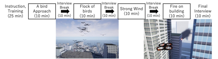
The data collected from the 40 participants (M = 24.6, SD = 5.55) were divided into four groups with two between-subjects factors: whether geographic instructions were provided beforehand, and map type (Road or Satellite). They completed four scenarios with various emergency occurrences: a bird approaching (S1), a flock of birds on the route (S2), sudden strong wind (S3), and a fire in a building on the route (S4) (see Figure 1).
Figure 1: Schedule and the scenarios for the experiment.
The participants signed an informed consent form that included questions about their proficiency in controlling drones and their familiar with the location used in the experiment. After each scenario, participants were interviewed and given a break. An ethical approval was obtained from the ethics committee of the Institute of Systems and Information Engineering, University of Tsukuba (Approval number: 2022R706R).
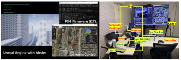
A drone simulator built using Unreal Engine 4 and PX4 software modules, QGroundControl, and the AirSim engine was developed and used for the experiment (see Figure 2). A 3D map of the Akihabara area was added to the Unreal Engine project to simulate a drone flying over a populated area in a BVLOS operation. The information of the map, units, vehicle status and
Effects of Threat Visibility and Geographic Knowledge on Attention Allocation 2179
flight plan functions were provided through the QGroundControl, which is the GCS application. A Xbox joystick controller was used for flight control, and participants used the controller to intervene in autonomous flight control based on the operator’s decision-making.
Figure 2: The structure of drone simulator apps and experiment environment with simulator, eye tracker and cameras (Maeng et al., 2024).
A Tobii Pro Nano eye tracker was used to record eye movements during the simulation. The eye movements including fixations and saccades were recorded.
The details of the experiment can be founding in Maeng et al. (2024).
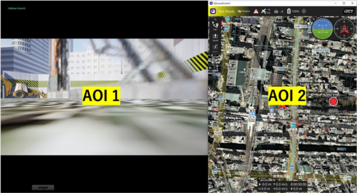
ANALYSING THE RESULTS: GTE, SGE AND AOI TRANSITIONS The fixation data were logged and categorized as either AOI 1 (FPV) or AOI 2 (GCS) based on the X-axis value on the screen with the boundary set at 745.7 pixels from the left (see Figure 3).
Figure 3: AOI1(FPV) and AOI2(GCS) during the drone operation simulation.
2180 Maeng and Itoh
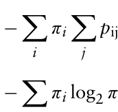
The equations for GTE and SGE are shown in Equations (1) and (2), respectively (Krejtz et al., 2015). Ht measures the predictability of eye movement transitions between AOI, with constant transition probabilities pij and stationary probabilities πi, where i and j are indices identifying the source and destination AOIs respectively (i, j ∈{1, 2}); a value 0 indicates completely predictable transitions where gaze always moves to the same AOI. Hs measures how evenly attention is distributed across AOIs over time.
X
Equation reproduced from the original PDF.
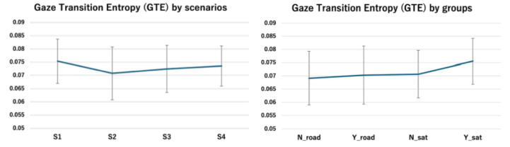
GTE AND SGE ANALYSIS Results showed that GTE and SGE were not significantly varied across map types, geographic instruction, and scenarios (see Table 1). GTE slightly lower in S2 and the group with instructions and satellite map showed highest GTE and the group without instructions and road map showed lowest GTE (see Figure 4). These GTE results suggest that when processing both immediate visual information and prior geographic knowledge, their eye movements become more random and less predictable, suggesting higher cognitive workload.
Table 1: ANOVA results for GTE and SGE measures.
Table available in the original PDF paper.
Source GTE SGE df F P Effect df F P Effect Scene 3, 108 1.85 .140 ns 3, 108 1.38 .252 ns Instruction 1, 36 2.23 .138 ns 1, 36 0.45 .503 ns Map 1, 36 0.29 .592 ns 1, 36 2.54 .113 ns
3, 108 0.61 .611 ns 3, 108 0.38 .769 ns
Scene × Instruction Scene × Map 3, 108 0.69 .557 ns 3, 108 0.34 .794 ns
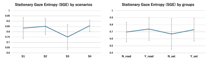
The SGE results suggest that especially the S3 with no visualized obstacle (wind) resulted in lower SGE, suggesting that their focus remained on a specific AOI: the FPV screen (see Figure 5). This is because, there was less need to move the focus to GCS to decide the next movement. The group with prior instructions shows higher SGE.
Effects of Threat Visibility and Geographic Knowledge on Attention Allocation 2181
Figure 4: The graph of GTE across four scenarios (S1-S4) and groups: N = no instruction; Y = with instruction; road = road map type; sat = satellite map type. Error bars represent standard deviations.Figure 5: The graph of SGE across four scenarios (S1-S4) and groups: N = no instruction; Y = with instruction; road = road map type; sat = satellite map type. Error bars represent standard deviations.
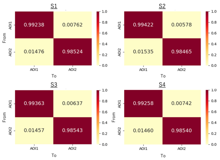
AOI Gaze Transition Probability Although the GTE and SGE showed no significant relationship between scenarios, gaze transition probabilities from AOI 1 (FPV) to AOI 2 (GCS) and from AOI 2 to AOI 1 showed significant difference across scenarios (see Table 2, F(3, 108) = 4.68, p = .004**, respectively). S1 and S4 showed high transition probability from AOI1 to AOI2 (see Figure 6). In contrast, S2 had a low probability. On the other hands, the transition probability from AOI2 to AOI1 is shown higher in the S2.
It can be the result strongly supports that the characteristics of emergency factors could affect the level of risk and cognitive load suggested in previous studies. These findings reinforce the need for detailed risk assessment classification, particularly based on the nature of the emergency situation and, in particular, the visual characteristics of the threat.
Table 2: The result of ANOVA of AOI transition by scenarios.
Figure 6: The gaze transition probability matrices of AOI transition across scenarios.
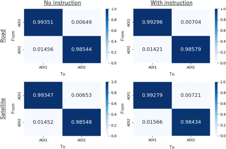
There was no significant relationship across map types or instruction conditions. However, it was possible to confirm that the transition from AOI1 to AOI2 was slightly higher in the group with instruction. The transition probability from AOI2 to AOI1, the group with instruction using satellite map type shows higher than other groups (see Figure 7).
Figure 7: The gaze transition probability matrices of AOI transition by groups.
Effects of Threat Visibility and Geographic Knowledge on Attention Allocation 2183
DISCUSSION
Our previous study demonstrated that map type significantly affected pupil diameter and suggested that risk assessment should relies on visual identification, location fixation, and threat predictability of obstacles (Maeng et al., 2024). Building on these findings, we hypothesized that: (1) map type affects GTE and SGE, (2) the absence of geographical instruction does not affect GTE and SGE, and (3) scenario characteristics affect GTE, SGE, and gaze transition probability.
The current study reinforces these findings by revealing that gaze transition patterns between AOIs differ significantly across emergency scenarios.
The current study partially supports these hypotheses. While GTE and SGE showed no significant differences across map types (rejecting Hypothesis (1)) or instruction conditions (supporting Hypothesis (2)), gaze transition patterns between AOIs differed significantly across emergency scenarios (supporting Hypothesis (3)). Specifically, S1 and S4, which involved visualized obstacles (bird approach and building fire) higher transition probability between different AOIs, on the other hands, S2 with a flock of birds, where the threat dynamically spread across a wide range, showed lower transition probability. This can be inferred to result from differences in the predictability of the visual obstacles’ subsequent movements. In cases a single small bird rushed forward, or smoke rose from a fixed location, their subsequent movements were not difficult to predict and could be avoided with a small detour. Therefore, participants likely had time to search for the detour direction or landing locations on the GCS map (AOI2) while monitoring the current situation (AOI1). However, in the case of a flock of birds, the size was large, and the random movements of individual birds required constant observation, leaving relatively short time to shift gaze to the GCS side. This confirms that the characteristics of emergency factors, specifically their visibility and predictability, affect operators’ cognitive processing and attention allocation strategies.
Beyond previous findings, although interpretation requires caution given the non-significant statistical differences, gaze entropy analysis provides potential insights into operator attention allocation strategies. S2 appeared to show a pattern resembling low GTE with high SGE, which may suggest systematic exploration behavior, though this tendency could also result from temporary gaze concentration on the dispersed bird flock. The low GTE with low SGE pattern observed in S3 (wind as a non-visualized obstacle) appears to indicate that operators maintained focused attention on the FPV screen when threats lacked visual cues. In contrast, a pattern of high GTE with high SGE was notable in the group using satellite maps with prior geographical instructions, which also showed larger pupil diameters in our previous study (Maeng et al., 2024). This may suggest that processing both immediate visual information and prior geographic knowledge increases eye movement randomness, potentially leading to higher cognitive load and increased demands when integrating multiple information sources during decision-making.
2184 Maeng and Itoh
While requiring further validation, these patterns point out the need for more comprehensive risk assessment frameworks that consider obstacle characteristics. The Specific Operations Risk Assessment (SORA) by JARUS provides detailed guidelines for ground and air risk classes yet lacks specific guidance for sudden aerial obstacles (JARUS, 2024a; 2024b; 2024c). Similarly, Banerjee et al.’s study presented a framework for real-time monitoring of obstacle collision risk under abnormal conditions such as component failure, control degradation, and environmental disturbances. Banerjee et al.’s study contributed to ensure safe operation of autonomous unmanned aerial vehicles (UAVs) during BVLOS flights in low-altitude airspace (Banerjee et al., 2021). However, their framework did not specifically address how visual factors of obstacles, such as visibility, predictability, and dynamic behavior, affect operator attention and decision- making processes.
Therefore, the findings in this study have important implications for operational risk assessment frameworks. The significant differences in gaze transition patterns across emergency scenarios emphasize the need for risk classification systems that account for aerial obstacle characteristics, particularly visibility, predictability, mobility, range, and potential cascading impacts. The findings suggest that training protocols and interface designs should be coordinated for various potential obstacle types. visualized threats with predictable movements may benefit from interfaces supporting rapid information integration across displays or background knowledge of geographic information through solid training, while unpredictable or non-visualized threats may require enhanced instrument readings and environmental indicators to maintain sustained situational awareness.
CONCLUSION
This study investigated operator attention allocation during BVLOS drone operations by analysing gaze transition entropy (GTE), stationary gaze entropy (SGE), and transition probabilities between the FPV camera view and GCS display across different emergency scenarios. Building on previous research that identified the effect of map types and geographic knowledge in operator decision-making, this study revealed that the characteristics of emergency factors, particularly the characteristics of obstacle visibility, significantly influence gaze transition patterns between information sources.
There are two main findings. First, emergency scenario characteristics significantly affect attention allocation strategies. Gaze transition probabilities differed significantly across scenarios. Scenarios with predictable visualized obstacles (bird approach, building fire) showed higher FPV-to-GCS transitions, while unpredictable threats (bird flock) showed lower FPV-to-GCS but higher GCS-to-FPV transitions. Second, gaze entropy metrics provide complementary insights when combined with transition probability analysis. While GTE and SGE showed no significant differences, transition probabilities revealed nuanced attention strategies. Integrating retained knowledge and immediate visual information increased
Effects of Threat Visibility and Geographic Knowledge on Attention Allocation 2185
eye movement randomness, particularly with satellite maps and prior instructions.
These findings emphasize the need for risk classification systems based on obstacle visibility, predictability, and spatial dynamics. Training protocols and interface designs should be tailored based on visibility of threats and the ability for integrating the information across displays and knowledge rapidly.
Just two AOI structure (FPV and GCS) used in this study may have limited the sensitivity of entropy measures. Future research should explore more granular AOI definitions, segmenting the GCS into specific functional areas to capture finer-grained attention patterns. Furthermore, by examining the temporal evolution of gaze entropy within a scenario and linking entropy patterns to decision quality and response time, the validity of these metrics as performance predictors could be validated. Finally, extending this research to real-world operational situations and various emergency types will strengthen the validity of our findings.
ACKNOWLEDGMENT
This paper is based on results obtained from a project, JPNP22002, commissioned by the New Energy and Industrial Technology Development Organization (NEDO). The authors thank ISHITSUKA Yuri and KONDO Yoshie for their great help.
REFERENCES
Banerjee, P, Gorospe, GE and Ancel, E (2021) ‘3D representation of UAV-obstacle collision risk under off-nominal conditions’, IEEE Aerospace Conference. Chew, JY, Kawamoto, M, Okuma, T, Yoshida, E and Kato, N (2021) ‘Multi-modal
approach to evaluate adaptive visual stimuli of remote operation system using gaze behavior’, International Journal of Industrial Ergonomics, vol. 86, https: //doi.org/10.1016/j.ergon.2021.103223. Cui, Z, Sato, T, Jackson, A, Jayarathna, S, Itoh, M and Yamani, Y (2024) ‘Gaze transition entropy as a measure of attention allocation in a dynamic workspace involving automation’, Scientific Reports, vol. 14, no. 23405, https://doi.org/10. 1038/s41598-024-74244-4. FAA (2022) Unmanned Aircraft Systems Beyond Visual Line of Sight Aviation
Rulemaking Committee Final Report, March 10. JARUS (2024a) Guidelines on SORA Annex F Theoretical Basis for Ground Risk Classification and Mitigation, Document Identifier: JAR-DEL-SRM-SORA-F-2.5, Edition 2.5. JARUS (2024b) Guidelines on SORA Annex H UAS Safety Services Considerations,
Document Identifier: JAR-DEL-SRM-SORA-MB-2.5, Edition 2.5. JARUS (2024c) Guidelines on Specific Operations Risk Assessment (SORA), Document Identifier: JAR-DEL-SRM-SORA-MB-2.5, Edition 2.5. Krejtz, K, Duchowski, A, Szmidt, T, Krejtz, I, González Perilli, F, Pires, A, Vilaro, A
and Villalobos, N (2015) ‘Gaze transition entropy’, ACM Transactions on Applied Perception, vol. 13, pp. 1–20. Maeng, S, Tu, N, Nishida, H and Itoh, M (2024) ‘Analysis of Effect of Geographic Information on Decision-making under Emergency Conditions during Beyond the Visual Line of Sight (BVLOS) Drone Operation’, Technical Journal of Advanced Mobility, vol. 5, no. 10, pp. 89–108, https://doi.org/10.34590/tjam.5.10_89.
2186 Maeng and Itoh
Moacdieh, NM, Devlin, SP, Jundi, H and Riggs, SL (2020) ‘Effects of workload and workload transitions on attention allocation in a dual-task environment: Evidence from eye tracking metrics’, Journal of Cognitive Engineering and Decision Making, vol. 14, no. 2, pp. 132–151. Sato, T, Jackson, A and Yamani, Y (2024) ‘Number of interrupting events influences
response time in multitasking, but not trust in automation’, International Journal of Aerospace Psychology, pp. 1–17. Shiferaw, B, Downey, L and Crewther, D (2019) ‘A review of gaze entropy as a measure of visual scanning efficiency’, Neuroscience & Biobehavioral Reviews, vol. 96, pp. 353–366, https://doi.org/10.1016/j.neubiorev.2018.12.007. Sorbelli, FB, Chatterjee, P, Das, P and Pinotti, C (2024) ‘Risk Assessment in BVLoS
Operations for UAVs: Challenges and Solutions’, IEEE DCOSS-IoT Conference, doi: 10.1109/DCOSS-IoT61029.2024.00053. Vidovi´c, A, Štimac, I, Mihetec, T and Patrlj, S (2024) ‘Application of Drones in Urban Areas’, Transportation Research Procedia, vol. 81, pp. 84–97, https://doi.org/ 10.1016/j.trpro.2024.11.010. Yucesoy, E, Balcik, B and Coban, E (2025) ‘The role of drones in disaster response: A
literature review of operations research applications’, International Transactions in Operational Research, vol. 32, no. 2, pp. 545–589.
LISTED IN THE AHFE DIGITAL BOOKSTORE CATALOGUE
Explore the complete digital volume
Human Factors in Design, Engineering, and Computing
Read this individual research paper free through the original publisher, or explore the full digital proceedings book.
ISBN 978-1-964867-75-5
Explore this ISBN in the AHFE Bookstore ↗Listed in the July 2026 bookstore catalogue; search by ISBN to confirm current availability · Digital book purchase optional