John McIntire, Haythem Mansour, Nadeen Sawaqued, Luke Schwab, Egduard Jauregui, Felicia Reinhart, Enoch May (2023). Innovative indoor navigation and route guidance solutions for first responders. In: Human-Centered Design and User Experience. AHFE Open Access, vol. 114, pp. 254–262. https://doi.org/10.54941/ahfe1004242
During emergencies, first responders must quickly and efficiently navigate to precise incident locations. Indoor navigation can be seriously challenging in large, complex, and often unfamiliar structures. This challenge is exacerbated by issues like distractions, lack of accessible or up-to-date maps, poor signage, lack of signage, and hampered visibility. Situations which could benefit from precise indoor navigational guidance may include active attackers, fires, HAZMAT, and various medical emergencies.In this work, we describe multiple projects that designed and prototyped innovative indoor navigation and route guidance solutions specifically for first responders. The projects were sponsored and mentored by US Air Force Research Lab (AFRL) and National Security Innovation Network (NSIN) personnel; and the technical work was conducted by undergraduate senior engineering students in a Design Innovation (DI) capstone course at the University of Colorado Denver. The first semester of each project was focused on conducting background research with first responders, end-users, customers, and subject matter experts, and performing DI ideation methods to generate and explore novel solution concepts. The second semester of the projects involved developing, testing, and showcasing proof-of-concept prototypes of their systems and/or subsystems.One team developed a computer-vision landmarking solution that allowed navigators to use small portable electronic devices (phone, tablet, bodycam) to determine self-location while moving through the space, and to receive turn-by-turn and distance-per-segment route guidance instructions when a destination was entered into the interface. Two other teams iterated on a pathway guidance solution concept that did not require carrying or handling any extra gear, and simply indicated desired pathways to a destination via the use of pre-installed electronic directional indicators. Both solution sets figured out innovative ways to route first-responders to emergency locations with little or no extra gear to be carried, and with robustness to changes in paths during transit.
Innovative Indoor Navigation and Route Guidance Solutions for First Responders 255
INTRODUCTION
During many emergency situations, first responder personnel need to quickly and efficiently navigate to precise incident locations within a larger event site. Indoor navigation can be seriously challenging in large, complex, and often unfamiliar structures, even when the desired destination is known to the responders, e.g., dispatched to South Building, 5th floor, Room 5238. This challenge is exacerbated by issues like distractions, lack of accessible or up-to-date maps, poor signage, lack of signage, hampered visibility (e.g., smoke, reduced ambient light levels, etc.) and the higher pace and inten- sity of movements required by emergencies. Situations which could benefit from precise indoor navigational guidance may include security events with the occurrence or risk of violence, fires, chemical spills, and various medical emergencies.
Consider the following hypothetical but realistic scenario, which demon- strates many of the main problems to be addressed: SCENARIO: At a major university, a report of gunshots fired in the Humanities Building is received by campus 9-1-1 dispatchers. Additional information suggests a shooter is on the 3rd Floor, possibly in Room 307. The first responders on the scene are two security officers, who enter the building from the main entrance. With weapons drawn, and with panicked bystanders rapidly rushing to the exits, the officers must quickly yet carefully find a stair- well, exit the stairwell at the 3rd floor, and then find Room 307 to locate and neutralize the active shooter. There is no current audible gunfire to guide them, and the building layout is complex and confusing. Bystanders are pan- icked and giving conflicting guidance on where the gunfire had come from, or where the incident room is located. The responders quickly glance around but directional signs are not immediately visible. The rooms they first approach don’t seem to be numbered in a recognizable pattern that would guide them in the appropriate direction to take at an intersection of hallways. They take several wrong turns, losing valuable minutes navigating aimlessly in an emer- gency situation in which every second counts. The room is eventually located and the shooter is apprehended by the officers, but there are several nearby wounded persons that need immediate medical attention. Responding EMT’s suffer the same navigational challenges that the original officers did, as they attempt to locate the appropriate location where care is needed as quickly as possible.
Optimally, tech solutions for this problem would be largely or entirely hands-free, so that first responders can focus on the task-at-hand with min- imal equipment distractions; also preferred solutions would require little or minimal pre-installed infrastructure which could encourage wider adoption, lower costs for scalability, and facilitate easy installation and upkeep. In addi- tion to being useful for first responders during emergencies, it is possible that the same technology or concepts could be utilized by staff or perhaps even the general public in non-emergency scenarios; for example, by guiding visitors to a particular meeting room; or guiding maintenance staff to a particular wall panel.
Indoor positioning systems do exist in the commercial sector – e.g., see solutions including Mapwize, MappedIn, etc.; but these tend to be costly, require significant infrastructure integration for communications and power, and are not typically designed for hands-free operation. Unlike outdoor positioning systems such as GNSS constellations, there are no official stan- dard indoor PNT systems or specifications so the field remains fragmented and with little momentum in any particular direction: different technolo- gies used for indoor positioning systems include Wi-Fi, Bluetooth beacons, acoustic (ultrasonic) beacons, magnetic pattern sensing, RFID, optical-based computer-vision map-matching, inertial dead-reckoning, etc. (El-Sheimy & Li, 2021). Such systems are used often for inventory asset tracking and pub- lic wayfinding applications. Few such systems are constructed specifically for the unique needs demanded by the first-responder community.
In this work, we describe student projects that attempted to prototype innovative indoor navigation and route guidance solutions specifically for first responders. The projects were sponsored and mentored by US Air Force Research Lab personnel in the Security & Intelligence Branch at Wright- Patterson Air Force Base, OH; and the work was conducted by undergraduate senior engineering students in a Design Innovation (DI) capstone course at the University of Colorado Denver. This effort was additionally co-sponsored by the National Security Innovation Network, a Department of Defense Innova- tion Unit technology accelerator program. The first semester of the projects was focused on conducting background research with first responders, end- users, customers, and subject matter experts into the problem space, and performing DI ideation methods to generate and explore novel solution con- cepts. The second semester of the projects involved developing and testing proof-of-concept prototypes of their systems.
TEAM 1 SOLUTION: COMPUTER-VISION LANDMARKING Background research into the problem space, and discussions with first responders and stakeholders, revealed to this team that having little or no extra gear to carry, as well as having an “infrastructure-light” solution, were going to be critical design constraints on their solution concepts. Desired identified features would be fast, easily-accessible information that guides users “like when I’m driving and use my navigation to see arrows of where to go next” akin to turn-by-turn directions. Through further ideation and anal- ysis of their customer requirements, the team identified their most promising avenue of tech development would be through a user-carried or user-worn computer-vision (CV) system that interacts with passive landmark tags. The primary benefits of this approach are: (1) very light infrastructure require- ments – this only requires the installation of inexpensive signs at particular locations with CV-recognizable patterns; and (2) little or no extra gear -- as the first-responders often already carry a smart phone, tablet, and/or body cam.
Fundamentally, in terms of navigation, this solution provides two key types of informational elements: on-the-go positioning, and wayfinding guid- ance. Positioning means knowing one’s position on some map, and this is
Innovative Indoor Navigation and Route Guidance Solutions for First Responders 257
accomplished with the camera detecting the particular fiducial visual pattern markings placed at important navigational landmarks. On-the-go position- ing means they can get updated information about their position as needed during transit. Once a person knows where they are in space, and they know their destination, the next step in navigation is wayfinding – how to get there from here?
To wayfind, the system takes the information about the current position, and knowing the destination as entered on a mobile app (phone or tablet), the system computes an optimal path and then the user is provided turn-by-turn instructions to reach their destination. This setup provides a beneficial and important capability if a user becomes lost on their journey and strays off the desired path or misses a turn. The user would simply find another fiducial tag, scan it, and the directions to the set destination are instantly updated. If a first-responder were to find that one avenue of approach is blocked due to crowds, fire, debris, furniture, temporary walls not listed on the map, etc. they can simply move around the obstacle on a new path until a different tag is spotted by the CV system. The turn-by-turn directions are provided, in the prototype system, using a textual description on the device’s visual interface, but could conceivably be converted to auditory instructions via text-to-voice software such that first responders could travel fully eyes-free and hands-free during all portions of indoor wayfinding.
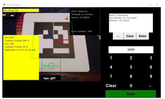
The computer-vision fiducial landmark patterns that this team used are conceptually similar to the now familiar and ubiquitous QR (quick response) codes (Figure 1, left), which are also two dimensional binary visual patterns. The team used fiducials called “AprilTags” (Figure 1, right) due to their open source nature, large print and easy machine readability which offered optical robustness to changes in distance, ambient lighting, and viewing angle condi- tions (Figure 2). Other CV tags include ARToolKit tags, ARTags, ArUco tags (e.g., see https://en.wikipedia.org/wiki/ARTag). A somewhat similar proto- type system to the one invented by this team used fiducial markers placed on the ceiling, as has been described by the excellent work showcased in Khan et al., (2019).
Figure 1: Left: QR code example. Right: AprilTag example.
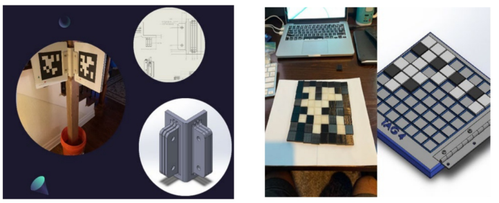
The team also developed a prototype concept for positioning the marker tags at various locations around a facility that could be easily mass-produced, easy to set up, reliably scanned, and physically robust to last over time (see
Figure 3, left). The tags themselves were printed on Dibond (an aluminum composite) with a solid polyethylene core; which is weather/temperature resistant, high strength/weight ratio, and non-corrosive. The bracket was 3D printed from a Solidworks design, printed with PLA, and designed to install on corners (key junctures for navigating). Low-light solutions were also explored to account for low ambient lighting conditions that might be experienced during emergencies; as well as a re-arrangeable generic tag tem- plate so that individual tags would not have to be printed each time; instead, the tag pattern could simply be re-configured as needed (Figure 3, right).
Figure 2: Photo of CV testing of the AprilTags as seen by the CV system, which provides the user the ability to enter a destination, and to view an inlaid textual distance and directional guidance to the next waypoint.Figure 3: Left: photo of the CV marker setup prototype placard holder, accompanied with engineering drawing and CAD model shown. Right: glow-in-the-dark option with re-arrangeable squares so that individualized tags don’t have to be printed for each pattern.
Innovative Indoor Navigation and Route Guidance Solutions for First Responders 259
TEAMS 2 & 3 SOLUTION: PATHWAY GUIDANCE These two teams worked with the same basic solution concept but across sep- arate academic years. Their solution is fundamentally different from Team 1’s in terms of navigational information collected and provided – e.g., it doesn’t provide any self-positioning information to users. Instead, this solution pro- vides route guidance (path wayfinding) assistance by illuminating an entire path once a destination is entered, with the system assuming a particular starting location (e.g., the destination input console is placed at the main entrance). Although this solution means the loss of capability for a user to do intermittent position updates along the way, it permits a key capability: a first responder needs no other additional gear, hardware, software, or user- system interactions to make use of the navigational guidance. A destination is entered once, at the start of the journey, at a fixed console that would already be in place; then the user follows the pathway guidance from there until the destination is reached.
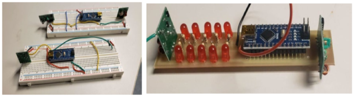
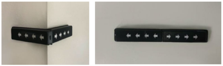
Team 2 suggested the use of linear LED light modules pre-installed at reg- ular intervals and at key intersections which could signal Left/Right/Stop through motion and blinking patterns. Each module could be stand-alone, and battery-powered (with a low-power sleep mode typically set) but would be daisy-chained or mesh-connected throughout a space so that the signal on what pattern each module should display would be passed by RF comms throughout the network (see module prototype evolution shown in Figures 4 and 5). Various placement/positioning concepts were tested to account for turns, stairwells, viewer visibility, etc. (see Figure 6).
Figure 4: Left: breadboard proof-of-concept using an Arduino Uno, prototyping bread- board, LEDs, and cabling. Right: altium EAGLE PCG Fusion 360 used for version 2.Figure 5: The module casing was 3D printed, with LED light cut-outs, and designed so that it could be affixed flat against a wall or hugging a corner.Figure 6: Different placement ideas of the pathway lighting modules were explored in a facility.
The follow-on Team 3, working on the same issue a year later, also realized that with multiple entrance points being possible, the system could indi- cate simultaneously a variety of paths from different starting points but a single end point (destination). This would allow essentially any first respon- der entering from any ingress point to be guided to the correct location. It also, quite advantageously, would allow in-transit re-routing if a particular path were to become unpassable for whatever reason (perhaps due to emer- gency). Effectively, by standing at virtually any position in the entire building, a person could follow the lighted display pattern signaling to arrive at the destination, with a variety of possible paths being possible.
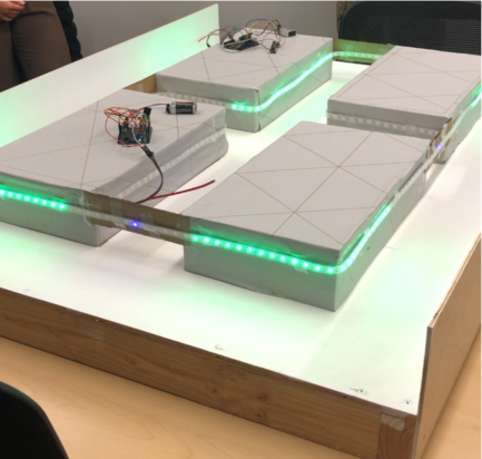
They built a small scale mock-up facility and utilized LED light strips to serve as the pathway lights. They programmed various light flow patterns to indicate directional routes, and showed the concept could indicate multi-path and re-routing capabilities to a single destination (see Figure 7). Mock-up control pads for manually entering a destination on a numerical keypad were also developed and tested.
Figure 7: LED light strips attached to protoyping control boards allowed for directional lighting patterns to be tested in a small-scale facility mock-up.
Innovative Indoor Navigation and Route Guidance Solutions for First Responders 261
DISCUSSION AND CONCLUSION We described several student innovation projects that designed and proto- typed new indoor navigation and route guidance solutions specifically for first responders. Each project invested significant effort in the Design Inno- vation process by conducting background research with first responders, end-users, customers, and subject matter experts, and performing DI ideation methods to generate and explore novel solution concepts. The teams also developed, tested, and showcased their proof-of-concept prototypes of their systems and/or subsystems.
One team developed a computer-vision landmarking solution that allowed navigators to use small portable electronic devices to determine self-location while moving through the space, and to receive turn-by-turn and distance- per-segment route guidance instructions when a destination was entered by a user. Two other teams developed a pathway guidance solution concept that interestingly did not require carrying or handling any extra gear, and simply indicated possible routes to a destination via the use of pre-installed electronic visual directional indicators. Both solution sets figured out inno- vative ways to route first-responders to emergency locations with little or no extra gear to be carried, and with robustness to allow route changes during transit.
Future work on route guidance technologies for first responders should consider utilizing, leveraging, or otherwise taking advantage of any types of electronic or communications gear carried by first responders for advanc- ing user-positioning schemes, such as cell phones, body cameras, digital tablets, etc. Efforts to develop gear-free solutions for the first responders that require pre-installed infrastructure in facilities for display signaling might benefit from piggy-backing on existing power and communications systems in these structures, in order to minimize the infrastructure footprint per unit cost, tech requirements, and system complexity. Critical design considera- tions for the first responder community that should be accounted for in future development efforts include multi-path simultaneous signaling to a single destination; the ability for navigators to perform in-transit re-routing; and avoiding the nuisance of carrying or manipulating extra gear during an emergency.
ACKNOWLEDGMENT
The University of Colorado Denver student team members who concep- tualized, developed, and tested these innovative technologies should be recognized for their contributions to this R&D effort. We also wish to thank the Capstone Design Innovation course instructors at CU Denver, Prof. Chad Hawkinson and Prof. Lary Speakman, for their collaborations, meetings, dis- cussions, and guidance; CU Denver capstone program creators Prof. Kris Wood and Prof. Dan Jensen; as well as our collaborators at the National Security Innovation Network, Brandon Greene, Cassie Heyman-Schrum, and Jeremiah Starr for their additional sponsorship and support, and mentorship to the students.
REFERENCES
El-Sheimy, N., & Li, Y. (2021). “Indoor navigation: State of the art and future trends.” Satellite Navigation, Volume 2, No. 7. Khan, D., Ullah, S., Nabi, S. (2019). “A Generic Approach toward Indoor Navigation
and Pathfinding with Robust Marker Tracking.” Remote Sensing, Volume 11, p. 3052. Mapwize [website]. https://mapwize.io, accessed 27 June 2023. MappedIn [website]. https://mappedin.com, accessed 27 June 2023. Soulier, M. (2021). “Indoor mapping: The basics.” https://www.mapwize.io/blog/wh at-is-indoor-mapping-wayfinding-indoor-positioning-and-navigation/
LISTED IN THE AHFE DIGITAL BOOKSTORE CATALOGUE
Explore the complete digital volume
Human-Centered Design and User Experience
Read this individual research paper free through the original publisher, or explore the full digital proceedings book.
ISBN 978-1-958651-90-2
Explore this ISBN in the AHFE Bookstore ↗Listed in the July 2026 bookstore catalogue; search by ISBN to confirm current availability · Digital book purchase optional