Francisco Javier Rafful Garfias (2026). Closing the Last Meter: A Markerless AR Framework for Precise Indoor Navigation. In: Human Interaction and Emerging Technologies (IHIET-AI 2026): Artificial Intelligence and Future Applications. AHFE Open Access, vol. 201, pp. 444–451. https://doi.org/10.54941/ahfe1007198
Indoor navigation remains challenging due to the degradation of Global Positioning System (GPS) signals in enclosed environments, leading to the last-meter problem—the difficulty of guiding users from a building entrance to a precise indoor destination. This challenge is particularly significant for individuals with visual impairments or reduced spatial orientation capabilities navigating complex multi-floor buildings. This paper presents a markerless augmented reality (AR) indoor navigation framework based on visual–inertial SLAM for infrastructure-free localization. The system performs real-time pose estimation on commodity mobile devices, constructs persistent spatial anchors, and computes vector-based navigation paths rendered as dynamically aligned AR overlays. Operating solely on onboard sensing, the framework enables scalable deployment without environmental instrumentation. Experimental evaluation in a two-floor academic building demonstrates centimeter-level localization accuracy for short-range navigation and stable performance across extended trajectories, including staircase transitions. The results support the feasibility of markerless AR navigation as a foundation for precise and accessible last-meter indoor guidance.
Navigating complex indoor environments remains difficult due to the degradation of Global Positioning System (GPS) signals in enclosed spaces. Consequently, users often reach a building entrance without reliable support for locating a precise indoor destination—a limitation known as the last-meter problem (Manduchi and Coughlan, 2014). This issue becomes particularly critical in large or multi-floor buildings and poses additional barriers for individuals with visual impairments or reduced spatial orientation capabilities.
For these users, interpreting two-dimensional maps and translating them into physical movement can increase cognitive load and disorientation (Sato et al., 2019; Klatzky, 1998). Scalable indoor navigation solutions that minimize infrastructure dependency while supporting precise spatial guidance remain limited.
Recent advances in visual–inertial simultaneous localization and mapping (SLAM) enable real-time pose estimation using onboard sensing (Mur-Artal and Tardós, 2017; Google Developers, 2025). When integrated
Closing the Last Meter: A Markerless AR Framework 445 with augmented reality (AR), these techniques allow navigation cues to be spatially anchored directly within the physical environment (Dong et al., 2021; Ahn et al., 2024). However, structured AR navigation systems with validated fine-grained localization performance remain limited.
This paper presents a markerless SLAM-based AR indoor navigation framework that integrates localization with vector-driven path computation to deliver spatially anchored guidance on commodity mobile devices.
Experimental evaluation in a two-floor academic building demonstrates centimeter-level accuracy for short-range navigation and stable performance across extended trajectories, including vertical transitions.
The primary contributions of this work are: (1) a markerless SLAM- based AR indoor navigation framework for structured wayfinding; (2) a vector-based real-time path computation and spatially anchored rendering mechanism; and (3) quantitative validation of last-meter localization precision in a real multi-floor deployment.
RELATED WORK
Indoor positioning systems (IPS) have historically relied on radiofrequency (RF)–based localization techniques, including Wi-Fi fingerprinting and Bluetooth Low Energy (BLE) beacons (He and Chan, 2016; Faragher and Harle, 2015). These approaches estimate position using received signal strength or time-of-flight measurements and have been widely deployed in commercial environments. However, RF-based systems typically provide meter-level accuracy and require infrastructure installation and maintenance (Zhuang et al., 2018; Sato et al., 2019), limiting suitability for fine-grained navigation tasks.
To improve spatial precision, marker-based augmented reality systems introduced fiducial markers placed at predefined locations (Putra et al., 2025; Cheng, Chen, and Chen, 2017). While such methods provide stable pose estimation, they depend on artificial environmental modifications and periodic maintenance, constraining scalability in large or evolving indoor spaces.
Recent progress in visual–inertial odometry (VIO) and SLAM has enabled infrastructure-independent pose estimation using onboard sensors (Mur-Artal and Tardós, 2017). Commercial mobile frameworks such as ARCore support markerless spatial mapping on commodity devices (Google Developers, 2025). These systems establish persistent coordinate frames and spatial anchors without external hardware. Nevertheless, most SLAM-based AR implementations emphasize object placement or scene reconstruction rather than structured navigation pipelines with quantitative performance validation.
Augmented reality has also been explored as an alternative to traditional two-dimensional map interfaces. Prior studies report improved spatial awareness and reduced cognitive load when navigation cues are overlaid directly onto the physical environment (Narzt et al., 2006; Dong et al., 2021; Ahn et al., 2024; Seager and Fraser, 2007). However, many AR navigation
446 Garfias systems continue to depend on external localization infrastructure or building information models (BIM), limiting deployment flexibility.
Assistive navigation systems for visually impaired users further highlight the importance of accurate localization and semantic feedback (Sato et al., 2019; Manduchi and Coughlan, 2014; Ruan et al., 2026). These systems often integrate RF-based positioning with audio guidance but remain tied to instrumented environments.
In contrast to RF-dependent and marker-based systems, the proposed framework combines markerless SLAM-based localization with structured path computation to enable fine-grained indoor navigation using onboard sensing alone.
ENVIRONMENT MODELING AND ANCHOR GRAPH CONSTRUCTION The framework implements a markerless AR indoor navigation system based on visual–inertial SLAM. The system was developed in Android Studio using the ARCore SDK for real-time pose estimation and spatial mapping and deployed on a commodity Android smartphone equipped with an RGB camera and inertial sensors. The architecture separates offline environment modeling from online navigation to ensure spatial consistency.
During initialization, the environment is scanned using the mobile application. Visual–inertial odometry establishes a stable world coordinate frame Fw. A persistent anchor map is defined as M = {A1, A2, . . . , An}, (1)
where each anchor Ai is associated with a 3D position Pi ∈ R3 and a semantic label Li. Anchors represent navigable landmarks (e.g., entrances, corridors, staircases) and form a sparse spatial graph encoding permissible transitions.
Anchor positions are stored in the global coordinate frame and persist across sessions, enabling spatial reuse without environmental instrumentation.
REAL-TIME LOCALIZATION AND AR NAVIGATION Upon selection of a destination anchor Ak, the device pose at time t is estimated using SLAM:
T(t) ∈ SE(3), (2) from which the device position Pd is extracted. The navigation direction vector toward the target anchor is computed as:
Equation reproduced from the original PDF.
Closing the Last Meter: A Markerless AR Framework 447 A waypoint sequence
P = {W1, W2, …, W_m}, (5) is generated between Pd and Pk. These waypoints are rendered as spatially anchored AR breadcrumbs aligned with Fw and updated continuously as pose estimates are refined. Algorithm 1 summarizes the online navigation procedure.
Algorithm 1: Infrastructure-Free AR Indoor Navigation Require: Anchor map M, target Ak 1: while ∥Pk − Pd∥ > ϵ do 2: Estimate pose T (t) 3: Extract Pd 4: Compute v⃗ = Pk − Pd 5: Generate waypoints P 6: Render AR breadcrumbs in Fw 7: end while 8: return Navigation complete
The system assumes adequate lighting and moderate environmental dynamics to maintain SLAM stability. Minor environmental variation is mitigated through feature filtering and anchor refinement. The integration of markerless SLAM with vector-based path computation enables fine-grained indoor navigation using onboard sensing alone.
EXPERIMENTAL SETUP The framework was evaluated in a two-floor academic building comprising corridors, classrooms, shared areas, and staircases representative of typical indoor navigation environments. Routes included horizontal trajectories and vertical transitions to assess localization stability across elevation changes.
Three traversal distances were tested: 5 m, 20 m, and 50 m. Each traversal condition was repeated 10 times under controlled walking speed to evaluate repeatability and tracking robustness. Ground-truth positions were manually measured using calibrated reference points derived from the building floor plan. Human participants were not involved in this phase to isolate system- level localization performance.
Performance was quantified using three metrics:
Positional Drift (cm) — Euclidean distance between the estimated device pose and the ground-truth anchor position at the final waypoint.
Task Success Rate (%) — Percentage of trials completed without loss of tracking.
Computational Performance — Average rendering frame rate (fps) and end-to-end latency (ms).
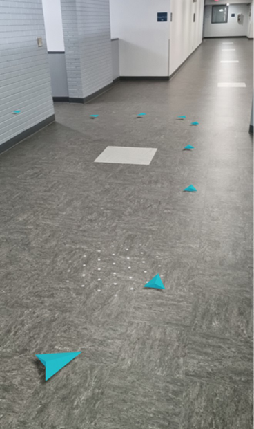
448 Garfias Experiments were conducted under standard indoor lighting conditions without external localization infrastructure. Figure 1 illustrates the AR breadcrumb overlay during deployment.
Figure 1: AR breadcrumb overlay during real-world deployment. Arrows are spatially anchored to the floor plane and aligned with the global coordinate frame.
RESULTS
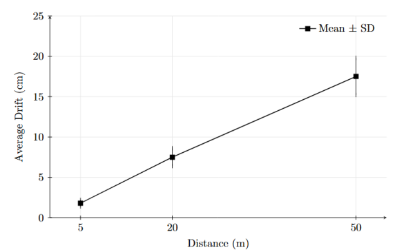
Table 1 summarizes positional drift and task success rates across traversal distances (mean ± SD over 10 trials). Figure 2 shows drift growth as a function of path length.
Figure 2: Mean positional drift (± standard deviation) as a function of traversal distance over 10 repeated trials.
Drift increased with traversal distance, consistent with cumulative visual– inertial estimation error. The near-linear growth trend is consistent with incremental pose estimation drift typical of visual–inertial SLAM systems. Short trajectories (5 m) exhibited sub-2 cm average drift with low variance, indicating stable short-range pose estimation. At 20 m and 50 m, variance increased moderately, reflecting cumulative error propagation over longer trajectories.
Despite drift growth, task success rates remained above 94% even at 50 m, indicating robust navigation performance across typical indoor scales. Localization remained continuous during staircase transitions, with no tracking resets observed.
The system maintained 30–35 fps with end-to-end latency below 100 ms, ensuring perceptually stable real-time AR guidance.
DISCUSSION AND LIMITATIONS The observed drift progression confirms the expected cumulative behavior of visual–inertial SLAM over extended trajectories. Despite error accumulation, system-level reliability remained sufficient for structured indoor navigation tasks, supporting the feasibility of infrastructure-free last-meter guidance.
Stable localization across staircase transitions indicates that markerless SLAM can maintain coordinate consistency across elevation changes without explicit floor registration. This suggests suitability for multi-floor deployment in structured environments.
The anchor modeling strategy employs sparse, landmark-driven representations rather than dense environmental reconstructions, enabling incremental expansion with moderate computational overhead. However, large-scale deployment may require hierarchical map management strategies that were not evaluated in this study.
450 Garfias Several limitations remain. Evaluation was conducted under controlled trajectories without human participants; therefore, usability, cognitive load, and accessibility benefits were not quantified. Performance may degrade in highly dynamic, texture-sparse, or poorly illuminated environments. Additionally, validation was limited to a single mobile device, restricting hardware generalizability. The current implementation emphasizes visual guidance and does not incorporate multimodal assistive feedback.
These constraints define directions for extending the framework toward scalable and human-centered deployment.
CONCLUSION AND FUTURE WORK This work presented an infrastructure-free AR indoor navigation framework that integrates markerless visual–inertial SLAM with vector-based path computation to deliver spatially anchored guidance without environmental instrumentation.
Experimental validation confirms that fine-grained indoor localization can be achieved using onboard sensing alone while maintaining real-time rendering performance suitable for continuous navigation. The framework demonstrates the feasibility of scalable, infrastructure-independent AR wayfinding in structured multi-floor environments.
Future research will focus on human-centered evaluation, multimodal guidance integration, scalable semantic mapping, and robustness under dynamic or low-texture conditions.
ACKNOWLEDGMENT
The author declares that no external funding was received for this work.
REFERENCES
Ahn, Yusun et al. (2024). “BIM-based augmented reality navigation for indoor emergency evacuation”, Expert Systems with Applications, 255, p. 124469. Cheng, Jack, Keyu Chen, and Weiwei Chen. (2017). “Comparison of marker-based
and markerless AR: A case study of an indoor decoration system”, in: Lean and Computing in Construction Congress (LC3): Proceedings of the Joint Conference on Computing in Construction (JC3), Heraklion, Greece, pp. 483–490. Dong, Weihua et al. (2021). “What is the difference between augmented reality and 2D navigation electronic maps in pedestrian wayfinding?”, Cartography and Geographic Information Science, 48(3), pp. 225–240. Faragher, Ramsey and Robert Harle. (2015). “Location fingerprinting with Bluetooth
Low Energy beacons”, IEEE Journal on Selected Areas in Communications, 33(11), pp. 2418–2428. Google Developers. (2025). ARCore overview and supported development environments. He, Shunqing and S.-H. Gary Chan. (2016). “Wi-Fi fingerprint-based indoor
positioning: recent advances and comparisons”, IEEE Communications Surveys & Tutorials, 18(1), pp. 466–490.
Closing the Last Meter: A Markerless AR Framework 451 Klatzky, Roberta L. (1998). “Allocentric and egocentric spatial representations:
definitions, distinctions, and interconnections”, in: Freksa, Christian, Habel, Christopher and Wender, Karl F. (eds.), Spatial Cognition, Lecture Notes in Computer Science, Vol. 1404, Berlin: Springer, pp. 1–17. Manduchi, Roberto and James M. Coughlan. (2014). “The last meter: blind visual guidance to a target”, in: Proceedings of the SIGCHI Conference on Human Factors in Computing Systems (CHI ’14), pp. 3113–3122. Mur-Artal, Raúl and Juan D. Tardós. (2017). “ORB-SLAM2: an open-source SLAM
system for monocular, stereo, and RGB-D cameras”, IEEE Transactions on Robotics, 33(5), pp. 1255–1262. Narzt, Wolfgang et al. (2006). “Augmented reality navigation systems”, Universal Access in the Information Society, 4(3), pp. 177–187. Putra, B. S. C. et al. (2025). “Adaptive AR navigation: real-time mapping for indoor
environment using node placement and marker localization”, Information, 16(6), p. 478. Ruan, Ligao et al. (2026). A multimodal assistive system for product localization and retrieval for people who are blind or have low vision, arXiv preprint. Sato, Daisuke et al. (2019). “NavCog3 in the wild: large-scale blind indoor navigation
assistant with semantic features”, ACM Transactions on Accessible Computing, 12(3), pp. 1–30. Seager, Will and Danae Stanton Fraser. (2007). “Comparing physical, automatic, and manual map rotation for pedestrian navigation”, in: Proceedings of the SIGCHI Conference on Human Factors in Computing Systems (CHI ’07), New York: ACM, pp. 767–776. Zhuang, Yuan et al. (2018). “A survey of positioning systems using visible LED
lights”, IEEE Communications Surveys & Tutorials, 20(3), pp. 1963–1988.
LISTED IN THE AHFE DIGITAL BOOKSTORE CATALOGUE
Explore the complete digital volume
Human Interaction and Emerging Technologies (IHIET-AI 2026): Artificial Intelligence and Future Applications
Read this individual research paper free through the original publisher, or explore the full digital proceedings book.
ISBN 978-1-964867-77-9
Explore this ISBN in the AHFE Bookstore ↗Listed in the July 2026 bookstore catalogue; search by ISBN to confirm current availability · Digital book purchase optional