Kai-Wei Hsu, Ching I Chen, Meng-Cong Zheng (2023). Exploring the Correlation between Campus Map Representation and Wayfinding Behavior through Virtual Environment. In: Usability and User Experience. AHFE Open Access, vol. 110, pp. 218–226. https://doi.org/10.54941/ahfe1003194
National Taipei University of Technology (NTUT) is located in the heart of Taipei's prosperous transportation district. The campus retains many architectural features from the early 20th century. The Red House Historic Monument, a designated historical site in Taipei City, has cultural tourism value in Taiwan's history. The campus is also surrounded by scenic spots such as the Huashan 1914 Creative Park and the Guang Hua Digital Plaza, which attract many tourists. However, the campus is divided into several school districts by major traffic arteries and has three main entrances and exits. Overcrowded layouts and unclear categorized information hierarchies are apparent problems. However, we must investigate why entrants and tourists cannot reach their destinations efficiently through the campus map.This study uses the National Taipei University of Technology campus as the experimental site. It aims to investigate the design of its mapping system through the wayfinding behavior in the virtual environment. The 3D software was used to build the existing architectural environment. Then the model was imported into Unity 3D to simulate a scenario where the participants could move freely around the campus from a first-person perspective. A total of 30 participants were recruited for the online experiment, and three sets of scenarios were provided to simulate wayfinding on the campus, with eight tasks in each set. The assessment methods include: 1) participants were asked to perform the tasks and record their behavior and thinking aloud; 2) a five-point Likert scale was used to record the participants' evaluation of the map and their feelings while performing the tasks; 3) semi-structured interviews were conducted to understand the reasons behind the decisions and behaviors to wayfinding. We found that the existing campus mapping system had two major design problems: 1) Missing information. Important sites were not marked on the map, so the participants could only find them at a loss. 2) Design flaws. The maps on the same road have inconsistent directions, which causes the participants to spend extra time to confirm the original information and wayfinding strategy and increases the error rate. The original color differentiation and numbering provided little help. Participants indicated that they did not always notice them; even if they did, they did not find it helpful or counterproductive. "You Are Here" information was incomplete, resulting in errors in route-finding decisions. The position of the map stand is not consistent with the orientation of the participants, which increases unnecessary thinking time. The map design and the distribution of the overall campus don't meet the users' needs. The results of the study provide us with an understanding of users' pathfinding behavior on campus, which can be used as a reference for subsequent design improvements.
Finding your way around an unfamiliar environment is a challenge for many people, especially with the complex environment and the variety of infor- mation available on campus. Therefore, it is imperative to enhance the user experience of finding their way around the campus. The most direct way- finder in the campus environment is the campus map. The map allows the wayfinder to locate their location and build their cognitive map and spatial knowledge. Provision of a landmark at a decision point affects the decision maker’s cognitive wayfinding strategies and facilitates positioning (Richter, 2007). The spatial knowledge provided by the map can help the wayfinder determine the direction and distance of the target and then plan the route (Golledge, 1999). The visual complexity of map information affects the way- finder experience (Keil et al., 2020). Compared with ordinary maps, thematic
Exploring the Relationship Between Campus Map Representation 219
maps emphasize the presentation of thematic concepts and the expression of thematic imagery and have clear objectives (Cheng et al., 2002; Cheng et al., 2003; Lee, 2004). The campus map to be studied in this study is a kind of theme map, so the design must follow the characteristics of the theme map elements (Chang, 1991).
National Taipei University of Technology (NTUT) is located in the heart of Taipei’s prosperous transportation district. The campus retains many architectural features from the early 20th century. The Red House Historic Monument, a designated historical site in Taipei City, has cultural tourism value in Taiwan’s history. The campus is also surrounded by scenic spots such as the Huashan 1914 Creative Park and the Guang Hua Digital Plaza, which attract many tourists. However, the campus is divided into several sch- ool districts by major traffic arteries and has three main entrances and exits. Overcrowded layouts and unclear categorized information hierarchies are apparent problems. However, we must investigate why entrants and tourists cannot reach their destinations efficiently through the campus map.
Virtual environments have become a new and viable experimental appro- ach in recent years. Many researchers have conducted experiments on virtual environments with prototypes and their counterparts in the real world to find the differences between them in terms of pathfinding cognitive processes and spatial knowledge acquisition. It is found that people find their way in the virtual environment and the natural world in a similar way, and there is no significant difference (Conroy, 2001). With this technology, all changes in the experimental environment can be done at a lower financial cost and in less time (Morganti et al., 2007). It can be used to evaluate or develop a wayfin- ding system before construction, avoiding the need for costly modifications after the physical structure is completed.
METHODS
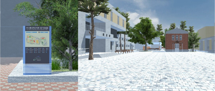
This study uses the Taipei University of Science and Technology as an expe- rimental virtual environment to investigate the pathfinding behavior under the campus mapping system design from different aspects. A virtual model of the exterior of the existing campus buildings was built using Blender and then imported into Unity 3D to simulate the first-person free-hand movement of the campus (see Figure 1). The movement is displayed on the desktop screen and controlled by the WASD keys and the mouse looking around the corner of the keyboard.
The test was conducted online using google meet due to the COVID-19 outbreak. Participants were given a virtual campus profile, used a google questionnaire with tasks assigned by the researcher, and were asked to share screenshots. Screen recordings and audio recordings were made throughout.
Three participants, aged 20-39, were recruited for the experiment. These participants had no previous experience visiting the campus of Taipei Univer- sity of Technology. In the first stage, the participants were asked to complete a basic information questionnaire and their experience playing 3D first-person perspective games. The questionnaire used the three-oriented questions of the Pathfinding Impact Factor Scale to understand the participants’ essential
Figure 1: The campus map vertical pointer (left) simulates the screen displayed when walking Campus map vertical pointer (right).
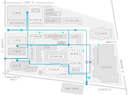
pathfinding ability and confidence. In the second stage, 30 participants were randomly divided into three groups, and each group was given a situational school pathfinding task. The three scenarios each had two tasks with six rou- tes, with the three main entrances appearing equally at the beginning and end of the task. In the middle of each task, there are three campus targets, and the participants must reach them accurately before they can continue their jour- ney. The number of turns for each of the six routes was 15 to ensure that the average difficulty was equal (see Figure 2). At the end of all tasks, participants were asked to complete a 5-point Likert scale comprehensive environmental assessment questionnaire in the third stage. Finally, semi-structured intervi- ews were conducted to understand their decision-making and behavior in route finding and why.
RESULT AND DISCUSSION
Behavioral Performance of the Participants During the Task The experimental results showed that among the six route-finding tasks in the three sets of scenarios, A2, B1, and B2 took more time (see Table 1). All three tasks had one thing in common: the starting and ending locations were concentrated at the side entrance of South Freshman Road and the Green Gate. The destinations that took the most time were the Art Center, the Third Academic Building, and the Red House. The problem with the Arts Center is that the existing campus map lacks information on the location of the buil- ding, leaving the participants to search for it blindly on campus; its location is relatively unknown, making the participants spend more time on the task. The third building was located on the opposite side of the main road, which led to suspicion or uncertainty when the participants arrived at the location of the third building because they could not find the name of the building. The existing campus map has the names of the buildings numbered from the top left to the bottom right of the campus according to the overhead view and placed at the bottom of the map. The issue with the Red Building is that
Exploring the Relationship Between Campus Map Representation 221
Figure 2: Three official task starting points and target points.Table 1. Average completion time of each task (seconds).
it is not listed as a building and a viewpoint but directly on the map. The par- ticipants responded that such information was presented in an inconsistent logic and was easily missed during visual search. We also found an inconsi- stency between the information on the map and the wayfinding process from the think-aloud recording. The first reaction of the participants was that they misread or misjudged the map information rather than doubting the reliabi- lity of the map, which would increase the time and decision-making difficulty of the wayfinding task.
By counting the number of map views during the task (see Table 2), we can determine whether the existing campus maps in the pathway can provide valid and accurate information. From the statistical results, we found that the number of map views was correlated with the task completion time. From the conversation logs and semi-structured interviews after the task, there were two main reasons for repeated map views: (1) the information needed could not be found on the map. For instance, the missing Art Center information and the Red Building information are presented differently from other buildings. (2) inconsistencies between maps. The current campus map is divided into a main map near the main entrance and a sub-map inside the campus, totaling seven maps. The inconsistent presentation of information on the maps along the same road will cause difficulties in viewing and making decisions and will increase the thinking time of the participants. These two problems reduce the functionality of the map itself and affect the experience of route finding.
Ratings Reported by Participants in the Questionnaire After completing the task, participants were asked two questions to evaluate the map during the wayfinding task (“The campus map in this task was well understood”) (see Table 3) and their anxiety level (“This task made me feel anxious”) (see Table 4), both on a five-point Likert scale. The results showed that the A2, B1, and B2 tasks received lower ratings on the campus map among the three situations. That is the same as the results for the time to complete the task.
Exploring the Relationship Between Campus Map Representation 223
Table 5. The average of the overall environmental assessment scores for each scenario.
Table available in the original PDF paper.
Question A B C M 23.2 19.9 22.7 SD 4.51 5.93 6.61
The results of the overall environmental assessment questionnaire (see Table 5) completed at the end of all tasks showed that the participants did not find the comprehensive campus map very comprehensible (M = 3.13, SD = 1.08). However, they agreed that it was helpful for wayfinding (M = 3.33, SD = 1.18). In addition, participants gave higher scores to the main map (M = 3.46, SD = 0.9) near the main entrance compared to the sub- map inside the campus (M = 2.70, SD = 1.05). It indicates that they thought the main map was more helpful in finding their way around and that the existing sub-map of the campus did not meet the needs of the participants.
The Effect of Relevant Game Experience on Pathfinding Performance Participants were asked about their experience with 3D first-person perspe- ctive games in the pre-experimental questionnaire. 22 of the 30 participants reported that they had played the game, while eight reported that they had never been exposed to it. After the T-testing of game experience and task com- pletion times, Task 1 in Scenario A and Task 2 in Scenario C were found to be significant. It shows that although the participants moved freely at a con- sistent speed during the simulated pathfinding process, in some cases, those with 3D first-person perspective game experience could still reach the target relatively quickly. We also observed the behavioral performance during the task, where experienced players have a smoother performance in view angle rotation and manipulation movements. The inexperienced players sometimes made operational mistakes, leading to poor pathfinding.
The Effect of Directional Awareness on Pathfinding Performance This study analyzed the direction-finding ability-oriented questions using the Direction-Finding Ability Influence Factor Scale. We classified those with
scores higher than the mean plus one standard deviation as high spatial abi- lity and those with lower than the mean minus one standard deviation as low spatial ability. Seven of them were high spatial abilities, two were low spatial abilities, and the remaining 21 were normal spatial abilities. After the inde- pendent sample t-testing of high and low altitude abilities and the completion time of each mission, there was no significant difference. It shows no signifi- cant difference in the performance of the high directional perception ability in the pathfinding task. Similarly, no significance was found with task performa- nce or feedback for the other pathfinding anxiety and path memory-oriented questions.
Participants’ Feedback in Semi-Structured Interviews In the semi-structured interviews, ten people thought the You are here infor- mation was not easy to find, and 16 people thought it was impossible to determine their direction. Participants indicated that people with poor spa- tial ability or sense of direction may have increased considering time and difficulty in making decisions about finding their way. Regarding the color distinction and numbering of buildings on the existing maps, 25 and 22 peo- ple did not find the information helpful. All participants thought the two pieces of information should be linked to benefit the reading process. In addition, some of the information on the map was disturbing to the partici- pants. Seven people thought the way the red buildings were labeled differed from other facilities, making it difficult to find them. Six people believed that some roads on the map looked passable but were not, forcing the partici- pants to change their route-finding finding strategies. Eight people thought that some buildings could not be identified from the front, making it chal- lenging to find the names of the buildings and reducing the pathfinding experience.
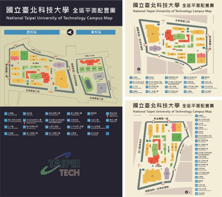
Regarding the location and overall layout of the campus map, 17 peo- ple said that the direction of the main map at the side entrance of South Freshman Road was not consistent with the actual direction, which caused interference in reading and judgment and increased the time for thinking and deciding. Eight people mentioned that the green gate should have a map to provide information; otherwise, they would have to search for the internal map blindly. As for the sub-map inside the campus, three people said they did not notice it at all, and four people thought it was not easy to read. The main reasons for this were that the map was too small and the placement angle was unsuitable for reading. Lastly, 16 people responded that there were inconsistent information and wrong directions on the maps. The three maps on the new South Road had three different directions of information pre- sentation (see Figure 3), which interfered with the original information and decision-making of the participants.
CONCLUSION
This study uses a virtual environment as the experimental approach, which has the advantage of better control over the variables and scope of the expe- rimental field and saves a lot of time and physical effort. The first-person
Exploring the Relationship Between Campus Map Representation 225
Figure 3: Two types of campus maps are available (three types of information presentation).
perspective of the participants’ pathfinding allows the researchers to under- stand what they observe in the environment. However, this experiment still has some limitations, as less “crowd” and “clutter” may impact perception and pathfinding behavior. In addition to the participant’s orientation perce- ption ability, the experience of 3D first-person perspective games may also affect the experiment’s performance. In addition, this study was conducted with a desktop computer screen, which has a narrower view angle than the actual walking field, and it is easy to ignore the scenery on both sides. How- ever, the virtual environment is still a feasible tool for evaluating the campus map pathfinding system.
The study’s results revealed that if the participants could not determine their location and orientation in the first place, it would significantly increase the time and difficulty of decision-making. The correlation between the pri- mary and secondary maps affects the smoothness of the navigation process, including the orientation of the map settings and the layout of the informa- tion content. The existing map elements are color-coded, and the buildings are numbered, so they are of little help. Participants indicated that they did not necessarily notice them; even if they did, they did not find them helpful or counterproductive. Overall, the layout on the campus map did not meet the needs of the participants.
Regarding design, there are two significant problems: missing information and information deficiencies. For the missing part, the primary goal of improvement is to fill in the critical information that does not appear on the existing map. For information deficiencies, the problem of inconsistent pre- sentation of information in the same direction of the map should be improved to avoid spending extra time to verify the original information and strategies. The information about “You are here” is incomplete, causing errors in the participants’ decision to find their way, and a more understandable and clear presentation should be proposed. The original color distinction and num- bering were adjusted to give practical help based on the feedback from the participants. The overall layout of the map settings will be optimized based on the experimental results to provide the most efficient layout for the best user experience.
REFERENCES
Conroy, R. A. (2001). Spatial navigation in immersive virtual environments. PhD diss., University of London. Golledge, R. G. (1999). Human wayfinding and cognitive maps. Wayfinding beha-
vior: Cognitive mapping and other spatial processes, 5–45. Jyun-Wun Chen, Wan-Lai You (2002). Visual Communication Design in Cartography. Design Research, 2, 117-127
Jyun-Wun Chen, Wan-Lai You, Shang-Jia Ciou (2003). Methodology and application
of pathfinding research. Design Research, 3, 222–223. Ke-Q uan Chang, Ren-Tao Huang (1991). Thematic map preparation, Beijing: Survey and Painting Publishing. Keil, J.; Edler, D.; Kuchinke, L.; Dickmann, F. (2020). Effects of visual map
complexity on the attentional processing of landmarks. PLoS ONE, 15, e0229575. Morganti, F., Carassa, A., & Geminiani, G. (2007). Planning optimal paths: A simple assessment of survey spatial knowledge in virtual environments. Computers in Human Behavior, 23(4), 1982–1996. Pei-Jin Lee (2004). A study on usability of wayfinding map styles. Master’s The-
sis, Department of Industrial Design, National Yunlin University of Science and Technology, Unpublished, Yunlin. Richter, K.-F. (2007). A Uniform Handling of Different Landmark Types in Route Directions. Lect. Notes Comput. Sci. 4736, 373–389.
LISTED IN THE AHFE DIGITAL BOOKSTORE CATALOGUE
Explore the complete digital volume
Usability and User Experience
Read this individual research paper free through the original publisher, or explore the full digital proceedings book.
ISBN 978-1-958651-86-5
Explore this ISBN in the AHFE Bookstore ↗Listed in the July 2026 bookstore catalogue; search by ISBN to confirm current availability · Digital book purchase optional