Veronica Solorzano, Malena Marin (2022). Design of inclusive urban itineraries: Case study in Guayaquil, Ecuador. In: Human Factors in Architecture, Sustainable Urban Planning and Infrastructure. AHFE Open Access, vol. 58, pp. 276–282. https://doi.org/10.54941/ahfe1002362
The present work is the result of an investigation on a proposal for the design of inclusive urban itineraries in the patrimonial area of Guayaquil. The applied methodology is based on the qualitative analysis of the traditional itineraries to universal access in the study area. The Right to the City is taken into account by giving participation to the different actors of territorial planning in decision-making to decide which areas should be considered as areas of interest to tourists. The results were illustrated in a tourist guide for the use of non-motorized mobility, considering the care of the environment, through the application of GIS tools that facilitate the understanding of national and international tourism.
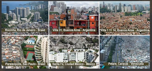
The World Health Organization (WHO, 2014) states, “currently more than half of the population resides in urban centers, by 2030 it may increase to 60% by 2030 and 70% by 2050”(Escobar, 2019). Latin America is currently the most urbanized region on the planet (80% of its population lives in cities) and at the same time it is the most unequal (75% of its cities have high rates of inequality) (CELADE, 2012). In most of the large Latin American cities, the marked socio-territorial inequalities that derive from the socioeconomic inequalities of their inhabitants can be verified. The neighborhoods of fami- lies with better economic resources are next to the neighborhoods of families with few resources, see Figure 1. However, a good city must be inclusive, pro- vide spaces for social commitment and promote social cohesion, addressing poverty and inequality through the provision of safe and accessible public spaces, especially for marginalized groups (UN HABITAT, 2021).
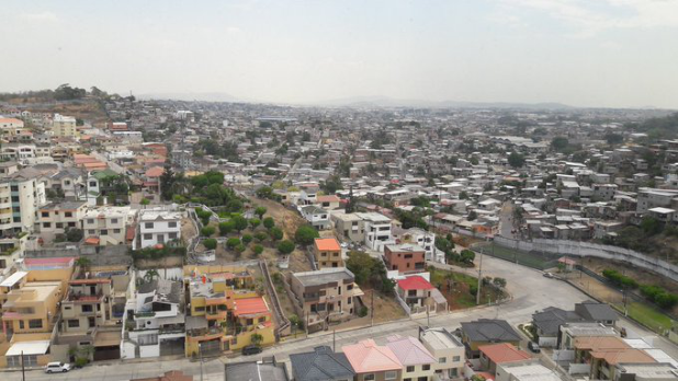
In Guayaquil we also find these marked differences (Sánchez, Hechavarría and Portilla, 2021). Figure 2 shows how the Los Ceibos citadels and the
Design of Inclusive Urban Itineraries: Case Study in Guayaquil, Ecuador 277
Figure 1: Socio-territorial inequalities in Latin American cities. Source: National University of La Plata.Figure 2: View of socio-territorial inequality in the city of Guayaquil. Source: https://twitter.com/tioelmoi/status/796732926125899776?lang=es.
Mapasingue Oeste sector are separated by a wall. These vulnerable neigh- borhoods, live informally and without basic services, are prone to problems of affordability of land and housing.
Considering the fulfillment of the Sustainable Development Goals in the urban planning of Guayaquil, ecological proposals are considered in the urban planning processes (Ávila, Fois, Hechavarría, 2020), (Tisalema et al. 2020), (Salvador et al. 2020), noise pollution (Calero L et al. 2020) and analysis on the inclusion and increase of green areas with proposals for native vegetation resistant to environmental challenges (Salinas, Vega and Hecha- varría, 2020). New methods are also used to help in the decision-making process (López, Vásquez and Hernández, 2020). In addition to considering the special conditions of disability (Colorado et al. 2019), (Forero et al. 2018) and universal access in the design stages (Hechavarría, Forero and Vega, 2020). Urban planning must consider life between buildings conside- ring the public space (Gehl, 1971) where walkability and cycle paths play
278 Solorzano and Marin
a fundamental role to achieve it. On the other hand, civic promotion cam- paigns must be created that expose the importance of the arcade, and how they help to walk the city. In this way, awareness of the city can be created and appreciation for public spaces that ultimately benefit all the people who live in an urban nucleus. For this, a recovery and rescue plan for the arcades must be implemented (Santana, 2015), it is not enough to include them in local laws, it is necessary that the inhabitants of the city take ownership of these traditional spaces.
METHODOLOGY
The applied methodology is based on the qualitative analysis of the traditi- onal itineraries to universal access in the study area, this technique allows to discover the different possibilities and resources that are needed to have sustainable and inclusive cities and to carry out the improvements in public spaces. Subsequently, bibliographical information was collected, through the analysis of references to demarcate the study space, this led to knowing the natural and social environment. The documentary review carried out contri- butes to the elaboration of the theoretical support of the research, establishing a guide with criteria in accordance with the proposed model of inclusive and sustainable urban routes. Guayaquil, by continuing to have horizontal growth, like most Latin American cities, has become a more dispersed city with difficulties in accessing a decent habitat, especially for the middle and low-income sectors, which are on the periphery from the city.
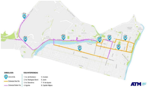
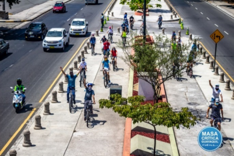
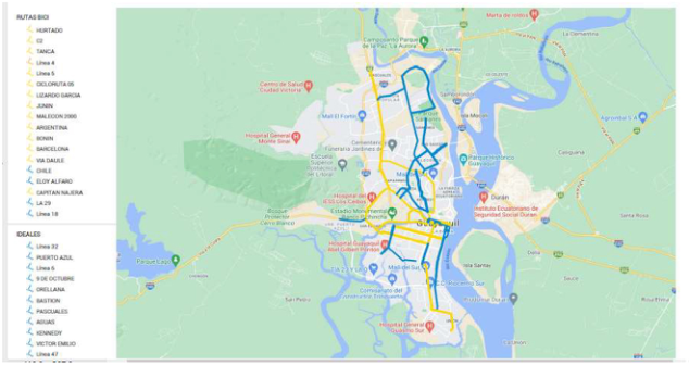
MOBILITY PLAN FOR GUAYAQUIL The new Mobility Plan that the Municipality of Guayaquil has launched, due to the Covid-19 pandemic, arises as a project of the Sustainable Urban Mobi- lity Table of the same entity and demonstrates its commitment to improve quality of life of its citizens by providing adequate spaces in the street, green areas, parks, recreational facilities and other public spaces. Among its parti- cipants is the Critical Mass Collective, which brings together several cyclists from the city and who have proposed a map with the most used bike lane rou- tes. The pyramid of sustainable mobility that the Municipality of Guayaquil proposes in its Ordinance approved on May 20, 2020, which regulates the use of bicycles and micromobility vehicles in the city, is taken as a platform. (Ponce, 2020). Its main system is 100 km of bike paths that cross the city from north to south and from east to west. The first stage is 14 km long, crossing the city from east to west from the edge of the Malecón Simón Bolívar to the banks of the Estero Salado on Av. Barcelona. In this last avenue, the four kilometers are bidirectional and occupy the central parterre.
The polygon is comprised between the streets: Malecón Simón Bolívar, Boulevard 9 de Octubre, Lorenzo de Garaycoa and Colón, as it is considered the commercial center of the city and where the most important heritage and historical buildings are located.
Design of Inclusive Urban Itineraries: Case Study in Guayaquil, Ecuador 279
Figure 3: Bicycle lane network in Guayaquil – Route 1 (East – West). Source: Traffic and Mobility Agency (In Spanish: ATM).Figure 4: Bidirectional section of cycle lane on Av. Barcelona. Source: Guayaquil critical mass.
Some routes coincide with the Malecón Simón Bolívar and Boulevard Nueve de Octubre, for the study the routes of Diez de Agosto and Chim- borazo streets also compete for being within the polygon of the proposal and for having several emblematic buildings of the city. The proposal for the design of inclusive and sustainable urban itineraries is projected in the commercial, economic and tourist center of the city. These proposals are for shared, pedestrian and cyclist circulation where the aim is to encourage the use of sustainable mobility, prioritizing circulation on non-motorized mobi- lity routes. The routes were implemented on the base plan of the urban cadastre of the city of Guayaquil in the geographic information system and they have been geo-referenced with real coordinates on site. 2 circuits are proposed: A: limits of the polygon that frames the streets Colón, Lorenzo de Graycoa, Boulevard Nueve de Octubre and the Malecón; B: Calle Diez de Agosto, Malecón, Aguirre and Seis de Marzo.
280 Solorzano and Marin
Figure 5: Proposal of bicycle path routes for Guayaquil. Source: Guayaquil critical mass.
In addition, a microroute is conceived along Chimborazo street from Colón street to Aguirre street. The routes prioritize the layout of green corridors in the routes of the streets Lorenzo de Garaycoa, March 6 and those adjacent to the Central Market (Clemente Ballén and August 10) for having little or no urban trees. On the other hand, Colón and Aguirre streets from García Avilés to the Malecón have trees in flowerbeds, on one side of the road or on both sides. They are considered fundamental components for mitigating the negative impacts of urbanization, in addition to benefiting the environmental balance in the face of climate change and serving as a pedestrian attraction.
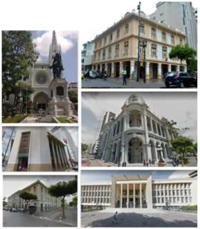
RESCUE OF THE ARCADES The planning links the main heritage buildings in the center of Guayaquil: Metropolitan Cathedral, Municipal Library, Municipal Palace, Government Palace and current University of the Arts, Library of the Arts, Consulate of Monaco, Central Bank building and current Corporation Financiera Naci- onal, Castillo Alavedra and Tama, buildings of the newspaper El Telégrafo and the newspaper El Universo, building of the Second Military Zone, San Francisco Church, Central Market among others; Most of them have a spe- cial feature: the arcades, which help protect people who carry out different activities in this area from the weather.
CONCLUSION
The methodology used promotes walkability as a key measure to bring people to public space, reducing vehicular congestion and boosting the local eco- nomy and interactions, as well as the improvement of the comfort of human activity, especially of pedestrians in the spaces between buildings. The itine- rary of the highlights the most representative sites of the city center, choosing the most commercial streets and at the same time with the greatest influx of public, especially during business hours where green and public spaces are
Design of Inclusive Urban Itineraries: Case Study in Guayaquil, Ecuador 281
Figure 6: Collage of heritage buildings in the center of Guayaquil. Source: own elaboration.
considered from a strategic planning perspective. and territorial intelligence to improve the mobility of pedestrians, cyclists and people with disabilities.
REFERENCES
Avila Beneras J, Fois Lugo M, Hechavarría Hernández JR. (2020) Strategies for accessibility to the Teodoro Maldonado hospital in Guayaquil. a design proposal focused on the human being. doi:10.1007/978-3-030-39512-4_192 Calero L, Calero M, Pazmiño C, Hechavarría J, Vélez E. (2020) Validation of an
Acoustic Model for Four Prototypes Sectors in Guayaquil City. doi:10.1007/978- 3-030-51566-9_8 Centro Latinoamericano y Caribeño de Demografía (CELADE)- División de Población de la CEPAL. (2012). Población, Territorio y Desarrollo Sostenible. Santiago, Chile: Naciones Unidas. Colorado B, Fois M, Leyva M, Hechavarría J. (2019) Proposal of a Technological
Ergonomic Model for People with Disabilities in the Public Transport System in Guayaquil. doi:10.1007/978-3-030-19135-1_81 Escobar, E. (2019). Bosques urbanos. Su importancia para el bienestar social y contribuir a la mitigación y los efectos del cambio climático en los centros urbanos. En E. Guerrero Forero, Voces sobre Ciudades Sostenibles y Resilientes (pág. 184). Bogotá: Ministerio de Ambiente y Desarrollo Sotenible. Forero B, Hernández JRH, Alcivar S, Ricaurte V. (2018) Systemic Approach for
Inclusive Design of Low-Income Dwellings in Popular Settlements at Guayaquil, Ecuador. Vol 876.; 2019. doi:10.1007/978-3-030-02053-8_93 Gehl, J. (1971). Life between buildings: using public space (Reimpresión 2020 ed.).
(J. Sainz, Ed., & M. T. Valcarce, Trad.) Copenhague, Dinamarca: Reverté.
282 Solorzano and Marin
Hechavarría Hernández JR, Forero B, Vega Jaramillo R. (2020) Universal Access and Inclusive Dwelling Design for a Family in Monte Sinahí, Guayaquil, Ecuador. doi:10.1007/978-3-030-39512-4_166 Lopez AP, Vazquez ML, Hernández JRH. (2020) Pedestrian traffic planning with
TOPSIS: Case study Urdesa Norte, Guayaquil, Ecuador. doi:10.1007/978-3-030- 55307-4_11 Ponce, T. (31 de octubre de 2020). Primicias.ec. Obtenido de https://www.primicias.
ec/noticias/sociedad/ciclismo-guayaquil-bicicleta-peligro-educacion/ Salinas J, Vega G, Hechavarría Hernández JR. (2020) Green Areas Plan with Native and/or Endemic Plants for Mitigation of Heat Island in Letamendi Parish, Guayaquil. doi:10.1007/978-3-030-51566-9_9 Salvador Minuche A, Pin Guerrero RM, Hechavarría Hernández JR, Leyva
Vázquez M. (2020) Ecological border implementation: Proposal to urban-natural transition in Nigeria, Guayaquil. doi:10.1007/978-3-030-55307-4_21 Sánchez Padilla M.L., Hechavarría Hernández J.R., Portilla Castell Y. (2021) Systemic Analysis of the Territorial and Urban Planning of Guayaquil. En: Ahram T.Z., Karwowski W., Kalra J. (eds) Advances in Artificial Intelligence, Software and Systems Engineering. AHFE 2021. Santana, C. (2015). Guayaquil, ciudad de soportales: una reflexión acerca de su
importancia y su uso actual. Pasos, 681–696. Tisalema S, Hechavarría J, Vega G, et al. (2020) Ecological Waste Planning. Case Study: Comprehensive Waste Management Plan at the Simón Bolívar Air Base, Guayaquil, Ecuador. doi:10.1007/978-3-030-58282-1_39 United Nations Human Settlements Programme. (2021). Her city. Obtenido de
https://hercity.unhabitat.org/
LISTED IN THE AHFE DIGITAL BOOKSTORE CATALOGUE
Explore the complete digital volume
Human Factors in Architecture, Sustainable Urban Planning and Infrastructure
Read this individual research paper free through the original publisher, or explore the full digital proceedings book.
ISBN 978-1-958651-34-6
Explore this ISBN in the AHFE Bookstore ↗Listed in the July 2026 bookstore catalogue; search by ISBN to confirm current availability · Digital book purchase optional