Daniela Quiñones, Andrés Barraza, Luis Rojas (2022). User eXperience Heuristics for Geoportals. In: Usability and User Experience. AHFE Open Access, vol. 39, pp. 44–50. https://doi.org/10.54941/ahfe1001689
A web portal is defined as a “website that acts as a connection to a collection of information or resources including sources, services, news, tutorials, tools and an organized collection of other references from different websites” (Maguire and Longley, 2005). Specifically, the expression “geospatial resources” is used for geospatial information and services, where this “geoportal” is a type of portal, where it deals with resources with these characteristics. Based on the review that we performed, we can define a geoportal as a website that is considered an entry point to geographic content on the web or, more simply, a website where geographic content can be discovered. Several features can define this type of portals. According to the “Spatial Data Infrastructure of Uruguay” (IdeUy, 2018), geoportals have the following characteristics: User interface; Metadata; Data access; Documentation; Contact; and Help.According to the ISO 9241-11 standard (2018), the User eXperience (UX) is defined as “the perceptions and responses of the person resulting from the use and/or anticipated use of a product, system or service”. The UX evaluation is an important task to perform when developing any kind of websites. It is necessary to assess whether the websites meet the needs of the users and whether it fits properly in the physical, social, and organizational context in which it will be used. In this regard, it is important to evaluate whether a geoportal is intuitive, easy to use, and allows users to complete their objectives. UX should be explicitly considered, since the information, the content, the, presentation and the structure of the website should generate a user-friendly experience, motivating people to use the several functionalities and tools provided by the geoportal.Heuristic evaluation is an inspection method where expert evaluators detect potential usability/UX problems, based on heuristics (Nielsen and Molich, 1990). Nielsen’s heuristics allow evaluators to inspect a website in a general way, without focusing on specific domain features. However, the above makes it difficult to detect usability/UX domain-specific problems. Geoportals have their own features that differentiate them from other products, so it is necessary to use a set of specific and appropriate heuristics for these types of websites. Moreover, we think that heuristics can help detecting problems related to UX, and not limited to usability aspects (Quiñones et al., 2018, Quiñones and Rusu, 2019).This article presents a set of 10 heuristics to evaluate the UX of geoportals. The heuristics were developed using the methodology proposed by Quiñones et al. (2018). The methodology proposes eight stages to develop and validate a new set of heuristics and can be applied iteratively, repeating the stages that are necessary to refine the proposed set. We performed a preliminary validation with UX experts in order to refine and improve the proposed set of UX heuristics for geoportals.
A web portal is defined as a “website that acts as a connection to a colle- ction of information or resources including sources, services, news, tutorials, tools and an organized collection of other references from different websites” (Maguire & Longley, 2005). Specifically, the expression “geospatial resou- rces” is used for geospatial information and services, where this “geoportal” is a type of portal, where it deals with resources with these characteristics. Based on the review that we performed, we can define a geoportal as a web- site that is considered an entry point to geographic content on the web or, more simply, a website where geographic content can be discovered. Several features can define this type of portals. According to the “Spatial Data Infra- structure of Uruguay” (2018), geoportals have the following characteristics: User interface; Metadata; Data access; Documentation; Contact; and Help.
According to the ISO 9241-11 standard (2018), the User Experience (UX) is defined as “the perceptions and responses of the person resulting from the use and/or anticipated use of a product, system or service”. The UX evalua- tion is an important task to perform when developing any kind of websites.
It is necessary to assess whether the websites meet the needs of the users and whether it fits properly in the physical, social, and organizational context in which it will be used. In this regard, it is important to evaluate whether a geoportal is intuitive, easy to use, and allows users to complete their objecti- ves. UX should be explicitly considered, since the information, the content, the, presentation and the structure of the website should generate a user- friendly experience, motivating people to use the several functionalities and tools provided by the geoportal.
Heuristic evaluation is an inspection method where expert evaluators detect potential usability/UX problems, based on heuristics (Nielsen, 1994). Nielsen’s heuristics allow evaluators to inspect a website in a general way, without focusing on specific domain features. However, the above makes it difficult to detect usability/UX domain-specific problems. Geoportals have their own features that differentiate them from other products, so it is neces- sary to use a set of specific and appropriate heuristics for these types of websites. Moreover, we think that heuristics can help detecting problems related to UX, and not limited to usability aspects (Quiñones & Rusu, 2019; Quiñones, Rusu, & Rusu, 2018).
This article presents a set of 10 heuristics to evaluate the UX of geoportals. The heuristics were developed using the methodology proposed by Quiñones et al. (2018). The methodology proposes eight stages to develop and validate a new set of heuristics and can be applied iteratively, repeating the stages that are necessary to refine the proposed set. We performed a preliminary validation with UX experts to refine and improve the proposed set of UX heuristics for geoportals.
The article is structured as follows: firstly, we show geoportal features; then we explain the heuristics development process; later we present the set of UX heuristics for geoportals; next we explain the preliminary validation; and finally, we present the conclusions and future works.
GEOPORTALS As presented above, a geoportal is a website that is considered an entry point to geographic content on the web or, more simply, a website where geographic content can be discovered. According to the “Spatial Data Infra- structure of Uruguay” (2018), geoportals have the following characteristics: User interface; Metadata; Data access; Documentation; Contact; and Help. After analyzing the geoportal features, we proposed the new set of heuristics that evaluate the following characteristics:
1. Reference Map: allows the user to locate the area of interest in context. It should be represented by a bounding box that distinguishes it from the main focus of the map. 2. Available layers: organized by categories which represent geographic information based on matters of interest. This allows grouping and searching by theme. 3. Tools: it includes navigation and scrolling tools on the map.
4. Coordinate and reference system: it defines a relationship between the geographic resource and the real world, using existing coordinate types. These can be by means of degrees, minutes, seconds, or decimal degrees character. 5. Scale: relationship of similarity or proportion between dimensions of the geographic resource and the real object of the earth. 6. Metadata: it is the information related to each resource available on the website. 7. Access to data: possibility of accessing what is known as “geo-services”. 8. Documentation: documentation presented to the user for the purpose of informing which standard is used and technical details of the portal. 9. Contact: section dedicated to representing the organization responsible for the administration of the geoportal, in order to establish contact between users and the administrator or managers. 10. Help: specific document dedicated to users to understand how to use the geoportal efficiently.
DEVELOPING THE USER EXPERIENCE HEURISTICS FOR GEOPORTALS To create the set of UX heuristics for geoportals we used the methodology proposed by Quiñones et al. (Quiñones & Rusu, 2019; Quiñones et al., 2018). The methodology presents 8 steps: exploratory stage, experimen- tal stage, descriptive stage, correlational stage, selection stage, specification stage, validation stage, and refinement stage. Table 1 describes the stages and activities performed to create the new set of heuristics.
To develop the UX heuristics for geoportals, the set of specific heuri- stics for geo-websites proposed by Komarkova et al. (2007) was used as a basis since it considers characteristics of geoportals, in addition to inclu- ding generic heuristics in its proposal. To specify the heuristics, we used the template proposed in the methodology (Quiñones & Rusu, 2019; Quiñones et al., 2018) including 10 elements: ID, name, definition, explanation, prio- rity, application feature related (geoportal), usability attributes, UX factors, examples, and existing related heuristics. We proposed a set of 10 heuri- stics. As a result of the preliminary validation, we refined and improved the heuristics specification.
USER EXPERIENCE HEURISTICS FOR GEOPORTALS We proposed a set of 10 heuristics to evaluate the UX on geoportals. Table 2 shows the set of heuristics including their ID, name, and definition.
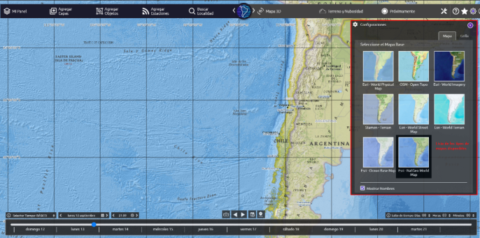
As an example, Figure 1 shows compliance and noncompliance of the heuristic GH10: “List of available services”. The figure represents the section corresponding to the maps available through the GEOOS Geopor- tal (https://geoos.org/); however, the difference between the available maps is not shown (something to improve).
User Experience Heuristics for Geoportals 47
Table 1. Methodology stages applied, and activities performed to develop the UX heuristics for Geoportals.
Table available in the original PDF paper.
Stages Activities performed Step 1: Exploratory stage – Literature review of main concepts, such as: user expe-
rience, geoportals, geoportal features, and existing set of heuristics. Step 2: Experimental stage – Not performed due to available time. Step 3: Descriptive stage – Selection of the set of heuristics to use as basis to develop the new set: Komarkova et al. heuristics (Komarkova, Visek, & Novak, 2007). – Selection of usability and UX attributes to evaluate
with the new heuristics: 5 usability attributes propo- sed by Nielsen (learnability, efficiency, memorability, errors, and satisfaction) (Nielsen, 2012); and 5 UX factors proposed by Morville (useful, usable, findable, credible, and valuable) (Morville, 2004). – Selection of specific features of geoportals (Adapted from (Infraestructura de Datos Espaciales de Uruguay, 2018)): Reference Map, Available layers, Tools, Coor- dinate and reference system, Scale, Access to data, Documentation, Contact, and Help. Step 4: Correlational stage – Association of usability attributes and UX factors to
the specific features of geoportals identified. Step 5: Selection stage – Selection of the heuristics to maintain, adapt, eliminate, and create using the Komarkova et al. heuristics (Komarkova et al., 2007). We adapted 9 heuristics; deleted 0 heuristics; and created 1 new heuristic. Step 6: Specification stage – Specification of 10 UX heuristics for geoportals using
the template provided in the methodology. Step 7: Validation stage – Preliminary validation of heuristics through experts’ judgement. Step 8: Refinement stage – Detection and documentation of improvements to be
made.
PRELIMINARY VALIDATION The set of heuristics was preliminary validated through expert’s judgment. The expert judgement involved two experts, all of them have participated in more than 10 heuristic evaluations and have experience in topics related to Human Computer-Interaction, Usability, UX, and use of geoportals. The validation consisted of a review by the experts of the 10 heuristics where they evaluated the wording, clarity, and usefulness. In addition, the experts provi- ded comments regarding the heuristic proposal and what changes should be made to evaluate specific characteristics of geoportals. Based on the feedback received, the heuristics proposal was refined. All heuristics were improved in terms of wording and clarity. After this preliminary validation, we are curren- tly conducting a validation of the proposal through a heuristic evaluation of the “GEOOS” geoportal (https://geoos.org/) with two groups of expert eva- luators: a control group that evaluate the geoportal using the heuristics of
Table 2. User Experience Heuristics for Geoportals.
Table available in the original PDF paper.
ID Name Definition GH1 Environment and user interface The geoportal should provide all the necessary basic navigation elements and information in an understan- dable way. GH2 Support in different browsers
The geoportal should successfully function in every bro- wser for which it was designed, without inconsistencies between browsers. GH3 Error preventions The geoportal should eliminate failure-prone conditi- ons or warn users before taking any important action through an alert that demonstrates the risk. GH4 Error handling The geoportal should provide users with information about the errors that occur and the possibility of fixing them. GH5 Flexibility, design, and aesthetics
All visual elements sections of the geoportal should use a part appropriate to the viewport. All control ele- ments should be clear and well distributed. The content should make sense and consistency. In addition, the geoportal should allow to adapt its interface accor- ding to the user’s personal needs (such as colors and languages). GH6 Ease of use The geoportal should be intuitive and functional to successfully complete the needs or objectives of the user. GH7 User privacy If the geoportal requires personal information from users, it should inform the reason for its use and ensure that all private information will be protected for the user’s security. GH8 Manuals and docu- mentation
The geoportal should have documentation and user manuals regarding the use, rules and legalities related to the application or website itself. GH9 User control and freedom
The geoportal should allow the user to navigate freely and offer the possibility of doing and undoing actions. GH10 List of available services
The geoportal providers should have a considerable number of maps for the user, in order to acquire dif- ferent types of information; in addition to consider the availability of the sources from which the information presented is obtained.
Komarkova et al. (2007); and an experimental group that evaluate the same geoportal but using the new heuristics proposal. The analysis of results will be performed according to what is stated in the methodology (Quiñones & Rusu, 2019; Quiñones et al., 2018).
CONCLUSION
Geoportals are not only useful for offering users access to a series of geo- graphic resources, but they also allow enriching information on natural resources and thereby improve decision-making for scientists, academics and professionals working in areas such as meteorology, fishery, government,
User Experience Heuristics for Geoportals 49
Figure 1: List of maps available in the GEOOS portal (https://geoos.org/).
among others. In this sense, having an intuitive, easy-to-use web portal that delivers reliable information is essential. For this reason, we proposed 10 heuristics that allow to detect potential usability/UX problems and thereby improve the user experience on geoportals. We performed a preliminary validation, and several improvements were made.
As future work we expect to perform new iterations and formally apply the validation and refinement stage of the methodology. We intent to validate the set of heuristics performing heuristic evaluations (in progress), user tests, and experts’ judgment (survey). We also pretend to refine the heuristics in order to improve its utility and effectiveness to detect specific usability/UX problems related to geoportal features.
ACKNOWLEDGMENT
Daniela Quiñones is supported by Grant ANID, Chile, FONDECYT INI- CIACIÓN, Project N° 11190759. Luis Rojas has been granted the “INF- PUCV” Graduate Scholarship. Luis Rojas is supported by Grant ANID BECAS/DOCTORADO NACIONAL, Chile, N° 21211272.
REFERENCES
Infraestructura de Datos Espaciales de Uruguay. (2018). Guía sobre geoportales.
Retrieved from https://www.gub.uy/infraestructura-datos-espaciales/sites/infrae structura-datos-espaciales/files/\hbox{2019--05}/GuíaGeoportales_Ed\hbox{01- -01}_0_0.pdf ISO 9241–11:2018. (2018). Ergonomics of human-system interaction — Part 11: Usability: Definitions and concepts. Retrieved January 3, 2022, from https://ww w.iso.org/obp/ui/#iso:std:iso:9241:-11:ed-2:v1:en Komarkova, J., Visek, O., & Novak, M. (2007). Heuristic Evaluation of Usability of
GeoWeb Sites. Lecture Notes in Computer Science (Including Subseries Lecture Notes in Artificial Intelligence and Lecture Notes in Bioinformatics), 4857 LNCS, 264–278. https://doi.org/10.1007/\hbox{978--3}-\hbox{540--76925}-5_20
Maguire, D. J., & Longley, P. A. (2005). The emergence of geoportals and their role in spatial data infrastructures. Computers, Environment and Urban Systems, 29(1), 3–14. https://doi.org/10.1016/J.COMPENVURBSYS.2004.05.012 Morville, P. (2004). Facets of the User Experience - User Experience Design. Retrieved
February 13, 2022, from https://semanticstudios.com/user_experience_design/ Nielsen, J. (1994). Usability inspection methods. Conference Companion on Human Factors in Computing Systems - CHI ‘94, 25(1), 413–414. https://doi.org/10. 1145/259963.260531 Nielsen, J. (2012, January 3). Usability 101: Introduction to Usability. Retrieved
February 13, 2022, from https://www.nngroup.com/articles/usability-101-introd uction-to-usability/ Quiñones, D., & Rusu, C. (2019). Applying a methodology to develop user eXperience heuristics. Computer Standards and Interfaces, 66. https://doi.org/10.1016/ j.csi.2019.04.004 Quiñones, D., Rusu, C., & Rusu, V. (2018). A methodology to develop usability/user
experience heuristics. Computer Standards and Interfaces, 59(November 2017), 109–129. https://doi.org/10.1016/j.csi.2018.03.002
LISTED IN THE AHFE DIGITAL BOOKSTORE CATALOGUE
Explore the complete digital volume
Usability and User Experience
Read this individual research paper free through the original publisher, or explore the full digital proceedings book.
ISBN 978-1-958651-15-5
Explore this ISBN in the AHFE Bookstore ↗Listed in the July 2026 bookstore catalogue; search by ISBN to confirm current availability · Digital book purchase optional