Dylan Leem (2026). Situated Lightness: A Local-First WebAR Framework for Democratizing Digital Heritage in Rural China. In: Human Factors and Systems Interaction. AHFE Open Access, vol. 230, pp. 154–164. https://doi.org/10.54941/ahfe1007987
Digital interventions in rural heritage sites often face a "double bind": the high-fidelity technologies (e.g., Native Apps, VPS) required for immersive storytelling are incompatible with the infrastructural realities of rural environments. This mismatch leads to "digital exclusion" and unsustainable deployment. In this paper, we present a Research through Design (RtD) inquiry into the "Nanshe Ancient Village" project. Through an iterative in-situ prototyping process, we developed a "Local-First WebAR" architecture that leverages infrastructural constraints as design resources. We articulate the "Situated Lightness" Framework, which comprises three dimensions: 1) Technological Permissibility, utilizing mapless geospatial calculation and hysteresis state machines to ensure resilience in disconnected zones; 2) Interactional Friction, reframing browser autoplay restrictions as "rituals of consent" to foster volitional engagement; and 3) Socio-Technical Accessibility, adopting a zero-installation, static-hosting model to democratize access for resource-constrained communities. Our findings demonstrate that "Appropriate Technology"-rather than high-tech acceleration-offers a more ethical and scalable pathway for re-enchanting public spaces and combating digital alienation.
The “Double Bind” of Digital Heritage In the practice of cultural heritage preservation and public space placemaking, we observe a significant “technological misalignment.” On one hand, driven by a pursuit of high-fidelity visual spectacles, mainstream tourism projects have increasingly experimented with technology-intensivde systems—such as Unity-based Native Apps, expensive Visual Positioning Systems (VPS), and cloud-based rendering (Neuhofer et al., 2014). While this “heavy-asset” model delivers exquisite visual experiences, it creates “App Islands”: users are forced to download massive installation packages and grant complex system permissions for content that lasts only a few minutes.
On the other hand, the reality of rural heritage sites often presents severe infrastructural constraints. Taking the Nanshe Ancient Village as a case study, we find that the high barriers to entry for these technologies clash
Situated Lightness: A Local-First WebAR Framework for Democratizing Digital Heritage 155 with the “messy” reality of diverse user devices and the lack of long-term maintenance resources. A deeper crisis lies in the fact that existing digital guides predominantly employ a “map-driven” visual paradigm. This forces visitors to lock their attention on screens, leading to a “heads-down” mode of engagement, echoing critiques of calm computing and attention diversion in ubicomp research (Rogers, 2006). This tension between “high technical thresholds” and “low-resource environments” constitutes a “double bind” (Warschauer, 2004) for digital intervention in rural areas. Designing experiences that are resilient to infrastructural limits while simultaneously combating digital alienation and guiding the public back to the real world remains a critical challenge in Human-Computer Interaction (HCI).
From “Technical Replication” to “Appropriate Design” Addressing these issues, this study draws on a long-term design practice in Nanshe Ancient Village to propose a “Local-First” lightweight technical path (Kleppmann et al., 2019). In our early explorations, we attempted to replicate the Native App experience within a Web environment but encountered strong resistance from browser policies and physical environmental noise (e.g., GPS drift (Zandbergen, 2009)).
Through a reflective Research through Design (RtD) process (Zimmerman et al., 2007; Gaver, 2012), we transformed these limitations—originally perceived as “defects”—into design “resources”: We employed Mapless blind navigation logic to reduce computational load and encourage users to look up.
We utilized a Hysteresis State Machine to convert uncertain signal fluctuations into stable narrative states.
We adopted a Static Hosting Architecture to break down the walls of app stores, achieving radical inclusivity.
Contribution The core contribution of this paper is the “Situated Lightness” Design Framework. Challenging traditional HCI assumptions of “seamless experiences” and “high bandwidth,” this framework advocates for a future- oriented, sustainable methodology for public space digital intervention through three dimensions: Technological Permissibility, Interactional Friction, and Socio-Technical Accessibility.
THEORETICAL POSITIONING This study is not an isolated technical experiment but sits at the intersection of Appropriate Technology, Infrastructural Studies, and Local-First Software. We construct the theoretical justification for this research by “grounding” these macro-theories within the specific context of Nanshe Ancient Village.
Appropriate Technology & Intermediate Technology E.F. Schumacher’s concept of “Intermediate Technology” in Small is Beautiful argues that technology should align with local resource endowments, cultural
156 Leem backgrounds, and maintenance capabilities, rather than blindly pursuing capital-intensive high-end technologies (Schumacher, 1973). In HCI, this idea has been further interpreted as “Designing for the Margins,” emphasizing that in resource-constrained environments, accessibility holds greater ethical value than sophistication. Our research inherits this tradition, opposing the forced implantation of “alien technologies” dependent on high bandwidth and expensive computing power in rural heritage sites. Instead, we advocate for a strategy of “Technological Frugality,” leveraging existing, low-cost Web infrastructure to build sustainable digital experiences. This is not merely a cost consideration but a sign of respect for the rural technological ecology.
Infrastructural Inversion Bowker and Star’s theory of “Infrastructural Inversion” points out that infrastructure is typically invisible and only becomes visible upon breakdown (Bowker & Star, 1999). In traditional digital design, designers often attempt to mask these breakdowns (e.g., loading spinners, signal drops) to maintain an illusory “seamlessness” (Chalmers & Galani, 2004). However, Chalmers’ concept of “Seamful Design” argues the opposite, advocating for the deliberate exposure and utilization of these technical seams (Chalmers & Galani, 2004). In this study, we apply this theory to the rural context: rather than futilely masking GPS drift and network latency, we transform these “infrastructural limitations” into “narrative features” through hysteresis state machines and explicit interactions, allowing users to perceive the space and confirm their presence (Dourish, 2001). We invert what were originally invisible limitations into the foreground of design.
Local-First Software & Data Sovereignty With the ubiquity of cloud computing, user data and application logic are increasingly centralized on servers. The “Local-First Software” manifesto by Kleppmann et al. critiques the fragility introduced by this cloud dependency and advocates for software that features “No Spinners” and where “The Network is Optional” (Kleppmann et al., 2019). We extend this engineering principle to the domain of cultural heritage. For ancient villages like Nanshe, Data Sovereignty is crucial. Reliance on third-party cloud services not only introduces long-term maintenance risks but also deprives the community of control over its own cultural data (Rothenberg, 1999). By adopting a pure client-side computing architecture, we ensure that local digital heritage narratives can persist independently, even if external networks are severed. This is not just a choice of technical architecture but a political practice of “Digital Empowerment.”
CONTEXT: THE “DIGITAL PARADOX” OF A WEALTHY HERITAGE SITE Attention Deficit amidst Connectivity
Nanshe Ancient Village is located in the hinterland of the Pearl River Delta (Dongguan), one of China’s most economically developed regions. Unlike remote villages, it possesses comprehensive 4G/5G network coverage and
Situated Lightness: A Local-First WebAR Framework for Democratizing Digital Heritage 157 ample tourism infrastructure. However, this high level of modern connectivity has not translated into deep cultural experiences. Instead, it has triggered a state that can be described as being “physically present but mentally absent”, as observed in studies of smartphone-mediated touristic experience (Wang et al., 2012). Field observations reveal that although visitors are surrounded by exquisite Lingnan architecture featuring red sandstone bases and green bricks, the majority of their attention is captured by short videos and social media feeds on their phone screens. High-bandwidth connectivity has paradoxically become a conduit for extracting users from physical space. The core challenge here is not transmitting data over weak networks, but competing for and redirecting user Attention within an information-saturated digital environment, guiding them back to the tangible textures of the ancient village.
The “App Island” and Unsustainable Heavy Assets Operationally, while the local economic conditions are superior, a “heavy- asset” digitization strategy remains unsuitable. Mainstream tourism solutions often require developing customized Native Apps or deploying expensive dedicated guide devices (Neuhofer et al., 2014). This model suffers from two structural failures:
Access Barrier: For ordinary tourists staying only 1-2 hours, downloading a Native App of several hundred megabytes imposes a significant psychological and operational burden (friction cost), directly resulting in extremely low user conversion rates.
Maintenance Trap: Even for a wealthy village collective, maintaining a Native App that requires constant adaptation to new iOS/Android systems is unsustainable in the long term. Lacking a professional technical team, many such apps become “digital zombies” within a year of delivery.
Thus, the reality of Nanshe calls for a “counter-intuitive” technical solution: it must be “light” enough (no download, use-and-go) to lower barriers, yet contain appropriate “interactional friction” (e.g., mandatory physical triggering) to combat ubiquitous digital distraction. We need not to fill an infrastructural gap, but to reconfigure the relationship between humans and infrastructure.
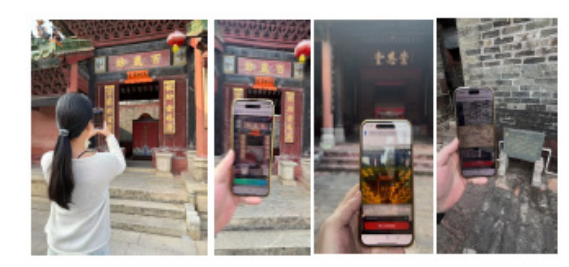
Figure 1: Situated interaction in Nanshe Ancient Village. (A) The architectural environment of the study site; (B, C, D) The handheld WebAR interface showing proximity-based narrative triggers in the physical context.
This study employs a Research through Design (RtD) methodology (Zimmerman et al., 2007). Given the specific context of Nanshe Ancient Village, we adopted a strategy of “In-situ Rapid Prototyping.” During a month of intensive development and field deployment, we engaged in continuous “build-test-reflect” cycles to identify the tensions between traditional AR paradigms and rural realities, deducing the final technical architecture. We document three core design tensions encountered during development and the resulting key design pivots.
Tension 1: Visual Navigation vs. Physical Presence Initial Design Intent: To assist tourists in finding scattered points of interest, we attempted to load Map Tiles on the web to simulate the visual navigation experience of mainstream LBS apps (Retscher, 2004).
Field Observation: Tests revealed that this design caused severe attention deviation. Visitors locked their gaze on the blue dot on the screen map rather than observing the surrounding red sandstone architecture or seeking landmarks.
Design Pivot-Mapless Navigation: We rapidly removed the map interface, shifting to a “Mapless” strategy. The system calculates distance in the background using the Haversine formula, while the frontend provides only minimal directional cues (e.g., “Find the West Gate”). This reduction forces users to look up (“Eyes-up”) and navigate by identifying physical landmarks, transforming technology from a “black hole of attention” into a “guide to the environment.”
Mathematical Formalization Instead of iterative high-precision geodesic distance computation, we implemented the Haversine Formula for determining the great-circle distance d between the user ( 1 ϕ , 1 λ ) and the anchor ( 2 ϕ , 2 λ ). This reduces the time complexity to ( ) 1 O , ensuring performance on low-end devices:
2 2 1 2 2 arcsin sin cos cos sin 2 2 d R φ φ φ [Equation or mathematical symbol available in the original paper PDF] ∆λ [Equation or mathematical symbol available in the original paper PDF][Equation or mathematical symbol available in the original paper PDF] ∆ [Equation or mathematical symbol available in the original paper PDF][Equation or mathematical symbol available in the original paper PDF][Equation or mathematical symbol available in the original paper PDF][Equation or mathematical symbol available in the original paper PDF] = ⋅ + ⋅ ⋅ [Equation or mathematical symbol available in the original paper PDF][Equation or mathematical symbol available in the original paper PDF][Equation or mathematical symbol available in the original paper PDF][Equation or mathematical symbol available in the original paper PDF][Equation or mathematical symbol available in the original paper PDF][Equation or mathematical symbol available in the original paper PDF][Equation or mathematical symbol available in the original paper PDF][Equation or mathematical symbol available in the original paper PDF][Equation or mathematical symbol available in the original paper PDF][Equation or mathematical symbol available in the original paper PDF][Equation or mathematical symbol available in the original paper PDF][Equation or mathematical symbol available in the original paper PDF][Equation or mathematical symbol available in the original paper PDF] Where ϕis latitude, λis longitude, and R is the Earth’s radius (R ≈ 6,371 km). This “Blind Navigation” logic decouples the experience from bandwidth- heavy map services.
Tension 2: Signal Instability vs. Narrative Continuity Initial Design Intent: We initially set a single distance threshold (e.g., triggering upon entering 15 meters) to achieve precise location response.
Field Observation: Even in open areas, the Multipath Effect of GPS signals caused the location point to jump within a range of several meters (Zandbergen, 2009). Under single-threshold logic, this minor physical drift caused digital content to toggle frequently between “play/pause,” destroying narrative immersion.
Design Pivot-Hysteresis State Machine: Inspired by control theory, we introduced a Schmitt Trigger logic, establishing non-overlapping entry ( inr )
and exit ( out r ) thresholds. This “hysteresis” mechanism introduced necessary inertia to the system, successfully filtering environmental noise and ensuring narrative stability even during signal fluctuations.
Algorithmic Logic Let tS be the state at time t (1 = Active, 0 = Inactive). The state transition is defined as:
t in
, , t t out
1 0 ,
d r S d r S r d r − t in t out
1
Equations and mathematical formulas are available in the original paper PDF.
Where inr < out r (e.g., 15 m vs 20 m). This inequality creates a stabilization buffer, mathematically filtering high-frequency noise without Kalman Filtering, thus preserving battery life.
Tension 3: Browser Policy vs. Interaction Flow Initial Design Intent: To lower the operational threshold, we attempted to bypass browser autoplay restrictions to achieve a “seamless” experience where audio plays upon arrival.
Field Observation: We found that strict Autoplay Policies in modern mobile browsers frequently intercepted audio requests, and purely technical workarounds (hacks) were unstable.
Design Pivot — Rituals of Consent: We transformed the limitation into a feature. Rather than fighting the browser, we aligned with its rules by designing explicit “Intentional Clicks.” When a user enters a geofence, the UI prompts for active confirmation. This not only resolved technical compliance issues but also established a psychological “contract of entry,” enhancing user agency (Dourish, 2001).
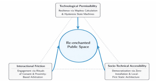
THE “SITUATED LIGHTNESS” FRAMEWORK Based on the aforementioned design research process, we distilled the “Situated Lightness” framework. This framework consists of three mutually supporting dimensions aimed at resolving the “double bind” prevalent in rural heritage sites.
Figure 2: The “Situated lightness” design framework.
Traditional digital heritage applications often operate on a “Thin Client” model, relying heavily on cloud-based services. In actual deployment, this dependency leads to system fragility. This framework proposes Technological Permissibility, granting the system permission to remain fully functional even in weak or disconnected network states.
Mapless Geospatial Calculation: We abandon visual map navigation in favor of direct client-side spatial calculation. Using the Haversine formula (spherical model) (Sinnott, 1984), the system calculates the great-circle distance between the user and the anchor point locally. Compared to iterative, convergence-based high-precision geodesic computation, the ( ) 1 O complexity of the Haversine formula reduces computational demand on low-end CPUs and, crucially, achieves “zero dependency” on high-bandwidth map tiles.
Spatial Hysteresis State Machine: To counter signal jumps caused by GPS multipath effects, we implement a hysteresis mechanism inspired by the Schmitt Trigger. By defining non-overlapping entry ( inr ) and exit ( out r ) thresholds (e.g., inr = 15m, out r = 20m), the system creates a buffer deadband. This mechanism “smooths” physical signal noise into a stable logical state, ensuring continuous narrative experience even when positioning accuracy degrades.
Dimension 2: Interactional Friction-Converting Constraints into Rituals of Engagement While mainstream UX strives for seamlessness, we leverage “Seamful Design” (Chalmers & Galani, 2004) to transform technical limitations into mechanisms that enhance the sense of presence.
Heuristic Interaction Strategy: Facing strict Autoplay Policies in mobile browsers, we abandon unstable bypass techniques in favor of “Intentional Clicks.” When a user enters a geofence, the system prompts via visual or haptic feedback rather than playing automatically. This explicit interaction, required by the user, complies with technical standards and experientially constitutes a “psychological confirmation” of intervening in the current historical narrative.
Proximity-Based Arbitration: In areas with dense heritage sites, to avoid information overload from simultaneous audio triggers, we implement a Mutex (Mutual Exclusion) mechanism based on distance sorting. The system strictly activates only the single nearest anchor point, suppressing others. This mechanism forces users to physically move to adjust their digital focus, thereby aligning digital attention with physical bodies.
Dimension 3: Socio-Technical Accessibility-From Walled Gardens to Radical Democratization Addressing the digital exclusion caused by “App Islands,” this framework advocates for Radical Democratization through extremely low technical barriers.
Situated Lightness: A Local-First WebAR Framework for Democratizing Digital Heritage 161 Local-First Static Architecture: We adopt a backend-minimal, pure static architecture (Kleppmann et al., 2019). All spatial judgment logic, state management, and media resource indexing are completed on the user agent (browser) side, requiring no continuous server-side computation. This means the system can be hosted on any inexpensive CDN or even local servers.
Zero-Installation & Ephemeral Access: Using the standard Web technology stack (HTML5/JS), the experience is distributed via URL, eliminating the need for app store downloads. This “use-and-go” characteristic removes users’ storage anxiety and privacy concerns (location data is not uploaded to the cloud), allowing digital heritage experiences to reach the broadest population, including users of low-end smartphones.
Implementation Strategy The system discards complex backend databases in favor of a Static Manifest architecture. The entire spatial logic is defined in a lightweight JSON structure, parsed locally by the User Agent.
/* Listing 1: The “Manifest” Structure for Local-First Execution */ { “experience_id”: “nanshe_west_gate”, “anchors”: [ { “id”: “poi_001”, “coordinates”: { “lat”: 23.0512, “lng”: 113.8821 }, “hysteresis”: { “enter”: 15, “exit”: 25 }, “media”: { “type”: “audio”, “src”: “assets/narrative/war_history.mp3”, “unlock_behavior”: “explicit_click” } } ], “arbitration”: “nearest_neighbor_mutex” } This declarative approach ensures that the “Digital Heritage” is preserved as simple text files, ensuring Long-term Digital Preservation beyond the lifespan of proprietary app stores (Rothenberg, 1999).
DISCUSSION: RE-ENCHANTING PUBLIC SPACE The contribution of this study extends beyond solving technical deployment issues in Nanshe Village; it proposes a general methodology for combating “digital alienation.”
Combating Digital Alienation With “Embodied Friction” In an era dominated by algorithmic recommendations, public spaces are increasingly reduced to backdrops for consuming short videos. This state of
162 Leem being “physically present but mentally absent” severs the connection between people and their environment (Wang et al., 2012). Our framework proposes a counter-narrative: technology should not aim to immerse users deeper into screens but should serve as a “Lure,” guiding them toward the physical world. By deliberately designing Interactional Friction (e.g., mandatory physical arrival, active clicking), we disrupt the dopamine loop of passive scrolling. This design requires the user’s body to be truly “present” in exchange for digital narrative. This is a form of “Slow Tech” that utilizes the lightness of the Web to guide people to rediscover the texture and depth of physical space, rather than replacing it (Dourish, 2001).
Generalizability: A Blueprint for “Everyday Public Spaces” Although this study is grounded in the context of rural heritage, the “Situated Lightness” framework possesses broad generalizability. It does not require expensive commercial-grade Visual Positioning Systems (VPS), such as those promoted in industry documentation (Niantic, 2024), or heavy server support, meaning that any community, school, or urban park manager lacking funds can build their own hybrid space using simple GPS coordinates and static web pages. From heritage preservation to Placemaking, this framework offers a low-cost, accessible path for the digitization of “everyday public spaces.” It represents a shift from “Smart Cities” (centralized, expensive) to “Civic Tech” (distributed, inclusive), empowering ordinary citizens with the right to rewrite spatial narratives. Extending Lefebvre’s notion of the “Right to the City” (Lefebvre, 1996), we argue for a corresponding “Right to the Hybrid City”—where citizens reclaim the narrative power of their physical environment.
CONCLUSION
Through design practice in Nanshe Ancient Village, this study challenges the current blind pursuit of “high fidelity” and “seamless experience” in the digital heritage field. We argue that in resource-constrained rural environments, transplanting city-level heavy technology stacks (such as Native Apps and cloud-based VPS) is not only technically unsustainable but ethically exacerbates digital exclusion.
Through the iterative process of Research through Design (RtD), we propose the “Situated Lightness” framework. This framework inverts infrastructural limitations—from unstable network signals to browser security policies— into design resources. Through Technological Permissibility (mapless blind calculation, hysteresis state machine), Interactional Friction (intentional click, proximity arbitration), and Socio-Technical Accessibility (zero-installation architecture), we successfully constructed a hybrid space narrative that is both resilient and human-centric.
This framework transcends simple technical solutions; it represents a value shift in digital intervention for public spaces: moving from locking passive users into screens to using lightweight technology as a “lure” to induce the public to re-engage with the texture and history of the physical world. We
Situated Lightness: A Local-First WebAR Framework for Democratizing Digital Heritage 163 believe that true “Appropriate Technology” should be that which can fade into the background, respect data sovereignty, and equitably empower every community to retell its own story. In the journey against digital alienation and the reconstruction of a sense of place, the wisdom of “lightness” may prove more powerful than the mere accumulation of computing power.
ACKNOWLEDGMENT
The author used AI-assisted tools solely for grammar checking and linguistic refinement. All ideas, interpretations, and research contributions in this manuscript were fully conceived and verified by the author.
REFERENCES
Bowker, Geoffrey C. and Star, Susan Leigh. (1999). Sorting Things Out: Classification and its Consequences. Cambridge, MA: MIT Press. Chalmers, Matthew and Galani, Areti. (2004). “Seamful interweaving: Heterogeneity
in the theory and design of interactive systems.” In: Proceedings of the 5th Conference on Designing Interactive Systems. pp. 243–252. ACM. Dourish, Paul. (2001). Where the Action Is: The Foundations of Embodied Interaction. Cambridge, MA: MIT Press. Gaver, William. (2012). “What should we expect from research through design?”
In: Proceedings of the SIGCHI Conference on Human Factors in Computing Systems. pp. 937–946. ACM. Kleppmann, Martin; Wiggins, Adam; van Hardenberg, Peter; and McGranaghan, Tom. (2019). “Local-first software: You own your data, in spite of the cloud.” In: Proceedings of the ACM SIGPLAN International Symposium on New Ideas, New Paradigms, and Reflections on Programming and Software. pp. 154–178. ACM. Lefebvre, Henri. (1996). Writings on Cities. Oxford: Blackwell. Neuhofer, Barbara; Buhalis, Dimitrios; and Ladkin, Adele. (2014). “A typology of
technology-enhanced tourism experiences.” International Journal of Tourism Research. 16(4). pp. 340–350. Niantic Inc. (2024). Lightship VPS Documentation. Available at: https://lightship.
dev/docs/ardk/features/lightship_vps/ (Accessed: 22 December 2025). Retscher, Günther. (2004). “Multi-sensor systems for pedestrian navigation.”
Proceedings of the 17th International Technical Meeting of the Satellite Division of the Institute of Navigation (ION GNSS 2004), Long Beach, California, September 2004, pp. 1076–1087. Rogers, Yvonne. (2006). “Moving on from Weiser’s vision of calm computing: Engaging UbiComp experiences.” In: International Conference on Ubiquitous Computing. pp. 404–421. Springer. Rothenberg, Jeff. (1999). Avoiding Technological Quicksand: Finding a Viable
Technical Foundation for Digital Preservation. Washington, DC: Council on Library and Information Resources. Schumacher, Ernst Friedrich. (1973). Small Is Beautiful: A Study of Economics as If People Mattered. New York: Harper & Row. Sinnott, Roger W. (1984). “Virtues of the Haversine.” Sky & Telescope. 68(2). p. 159. Wang, Dan; Park, Sangwon; and Fesenmaier, Daniel R. (2012). “The role of
smartphones in mediating the touristic experience.” Journal of Travel Research. 51(4). pp. 371–387.
divide. Cambridge, MA: MIT Press. Zandbergen, Paul A. (2009). “Accuracy of iPhone locations: A comparison of assisted GPS, WiFi and cellular positioning.” Transactions in GIS. 13(S1). pp. 5–25. Zimmerman, John; Forlizzi, Jodi; and Evenson, Shelley. (2007). “Research through
design as a method for interaction design research in HCI.” In: Proceedings of the SIGCHI Conference on Human Factors in Computing Systems. pp. 493–502. ACM.
LISTED IN THE AHFE DIGITAL BOOKSTORE CATALOGUE
Explore the complete digital volume
Human Factors and Systems Interaction
Read this individual research paper free through the original publisher, or explore the full digital proceedings book.
ISBN 979-8-950676-06-2
Explore this ISBN in the AHFE Bookstore ↗Listed in the July 2026 bookstore catalogue; search by ISBN to confirm current availability · Digital book purchase optional