Lucas Paletta, Georg Aumayr, Andreas Peer, Christian Perktold, Wolfgang Kallus, Patrick Luley, Stefan Ladstätter, Anna Weber, Sandro Eitzinger, Christian Schönauer, Friedrich Urbanek, Martin Söllner, Michael Schneeberger, Martin Pszeida, Christian Meurers (2026). The SmartResponse Framework: A Semantic Digital Twin Approach to Remote Emergency Command. In: Cognitive Computing and Internet of Things. AHFE Open Access, vol. 205, pp. 221–233. https://doi.org/10.54941/ahfe1007376
Remote incident commanders must coordinate disaster response without being physically present, while time pressure, incomplete information, and limited expert availability increase the risk. A novel framework – SmartResponse - develops the basis for future online command by integrating real-time 3D data acquisition, semantically enriched digital twins, and immersive, biosignal-assisted XR interaction for mission planning and communication with teams on site. This paper discusses the potential for digital twins to improve infrastructure management and remote emergency command. The workflow combines deployable sensing technologies, including LiDAR, calibrated cameras, inertial measurement, on-board processing, and broadband transmission, to stream 3D point clouds from an incident area to an operations centre. There, the scene is incrementally reconstructed into a semantically enriched digital twin that can be iteratively updated and augmented with hazard information, structural elements, relevant objects, and deviations from reference data. The resulting layer supports research on faster 3D situational awareness, hazard zoning, safer route planning, improved resource allocation, and more intuitive communication for distributed teams. A challenging dimension is the integration of emergency-critical human factors for system design and biosignal-based evaluation, including assessment under real emergency mission conditions.
Emergency response increasingly depends on the capacity of distributed teams to build a shared operational picture under severe time pressure, uncertain information quality, and dynamically changing hazards (Waring et al., 2020; Steen-Tveit & Munkvold, 2021). In many incidents, even the Received May 22, 2026; Revised June 18, 2026; Accepted July 8, 2026; Available online July 20, 2026
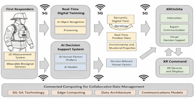
most experienced incident commander cannot remain continuously at the most hazardous location, yet still needs sufficiently rich information to allocate resources, interpret evolving risks, and coordinate specialized teams. Conventional command media such as radio traffic, 2D floor plans, video streams, and static geospatial layers remain indispensable, but they frequently fragment perception, delay comprehension of spatial relationships, and increase the cognitive effort required to transform raw observations into decisions. Building on this gap, the novel framework investigates a digitally mediated command capability in which real-time sensing, semantic mapping, digital twins, virtual reality, biosignal-based human factors assessment, and AI-supported assistance are combined into an integrated decision-support ecosystem. This framework embodies a concept to move from mere data visualization toward semantically structured, operationally meaningful support for emergency coordination (Figure 1).
The scientific challenge is not only technical reconstruction of the scene, but also the transformation of heterogeneous sensor inputs into an actionable representation that supports situation awareness, prioritization, communication, and resilient human judgment. In SmartResponse, the digital twin is therefore conceived as a living, semantically annotated operational model that links infrastructure knowledge, current field observations, detected hazards, route constraints, and human-performance indicators. Rather than replacing human command, the proposed system is intended to augment decision quality by reducing representational ambiguity, shortening the path from observation to interpretation, and enabling adaptive interaction support during high-stress moments. The paper presents the conceptual and methodological architecture and structures the contribution across sensing, semantic analysis, XR interaction, human-centred design, and exploratory field validation.
Figure 1: Schematic sketch of the SmartResponse framework (credit: Mastermind Development GmbH; ChatGPT 4.0 for drawing first responder).
RELATED WORK
The SmartResponse framework is positioned at the intersection of several research streams. First, the human factors literature has long shown that decision quality in dynamic domains depends on situation awareness, commonly described as the perception of relevant elements, comprehension of their meaning, and projection of future states (Endsley, 1995a, 1995b; Endsley & Jones, 2024). This perspective is especially relevant for emergency coordination because degraded information integration, workload, and time pressure can all impair command performance.
Human-centred design standards emphasize iterative development based on explicit understanding of users, tasks, and contexts of use (ISO, 2019). Therefore, sensing pipelines and immersive interfaces must be derived from operational practice rather than from technology push alone.
Research on Extended Reality (VR, AR/MR) in emergency management has shown value for training, preparedness, and visualization, while also revealing persistent challenges related to usability, cognitive load, and effective integration into operational workflows (Beroggi et al., 1995; Zhu & Li, 2021; Khanal et al., 2022). The literature suggests that immersive systems can improve spatial understanding, but only if interaction design minimizes distraction and supports task relevance.
Digital twin research increasingly highlights the role of live, data-driven virtual representations for infrastructure and disaster management. Recent studies argue that digital twins can improve response planning, scenario testing, coordination, and resource allocation when they are connected to timely sensing and domain-specific models (Lagap & Ghaffarian, 2024; Abrishami & Jayaram, 2025). Related work also points to the importance of semantic coupling between geometric data and operational meaning, for example by linking point-cloud structures with object categories, vulnerabilities, and procedural constraints.
Advances in point-cloud understanding demonstrate that AI-supported semantic segmentation can convert LiDAR data into structured representations of complex environments, although performance remains sensitive to noise, occlusion, and domain shifts (Grandio et al., 2022; Wang et al., 2023).
Finally, research on wearable stress monitoring and human-AI teaming is directly relevant to adaptive assistance: reviews indicate that multimodal biosignals such as heart rate, heart-rate variability, and electrodermal activity are informative for stress estimation, while trust, transparency, and shared cognition are central conditions for effective human-AI collaboration in safety-critical settings (Vos et al., 2023; Bolpagni et al., 2024; Schmutz et al., 2024). SmartResponse aims at the integration of these previously separate strands into one operational framework for remote and hybrid command.
DETAILED OBJECTIVES OF THE SMARTRESPONSE FRAMEWORK The overarching objective of the novel digital twin-driven framework is to establish the scientific and technological basis for remote, and hybrid operational coordination supported by semantically enriched digital twins. This broad aim is decomposed into several detailed objectives.
Construct an infrastructure-oriented semantic baseline before incidents occur. This baseline includes 3D models, known structural elements, utility-relevant features, access routes, hazard-relevant objects, and reference semantics that can later be compared with emergency-time observations.
Develop a deployable acquisition chain for collecting 3D data from the incident site under adverse and changing conditions. This requires sensor fusion, registration, synchronization, and transmission mechanisms that can tolerate partial data and variable bandwidth.
Transform raw spatial data into an operational digital twin that supports not only visualization but semantic inference. The twin should encode zones, landmarks, hazards, blocked passages, resources, and mission- relevant change detection.
Design an XR-based command environment in which remote decision- makers can explore the evolving scene, inspect uncertainty, query semantic layers, and communicate decisions to teams in the field.
To identify emergency-critical cognitive and psychophysiological demands, and to derive design principles for adaptive support during workload peaks and high-stress decision points. This objective is explicitly human factors oriented.
To integrate AI-based assistance that remains subordinate to human authority yet meaningfully supports interpretation, ranking, filtering, and interaction adaptation. This includes explainable assistance strategies rather than opaque automation.
To conduct exploratory field trials that evaluate feasibility, usefulness, usability, workload, and organizational fit across civil and military emergency contexts. These trials are not framed as a final efficacy demonstration but as a proof-of-concept pathway for progressive maturation.
Across all objectives, the project pursues an applied research contribution: showing how semantic mapping, immersive command interfaces, and human- centred AI can jointly produce a more robust and communicable operational picture than conventional fragmented information channels.
USER-CENTERED DESIGN Because the quality of an emergency interface is determined in practice rather than in the laboratory alone, we adopt a user-centred design process grounded in operational realities. Consistent with ISO 9241-210, the project begins by analysing users, tasks, environments, and organizational constraints before fixing design solutions (ISO, 2019). Primary users include remote incident commanders, field team leaders, technical specialists, and observers responsible for monitoring mission progress. Their information needs partly overlap but are not identical: commanders require integrated prioritization and projection, while technical specialists may require finer detail and diagnostic traceability. The design challenge is therefore not
The SmartResponse Framework: A Semantic Digital Twin Approach 225 merely to present more data, but to produce role-appropriate representations without fragmenting the shared operational picture.
The user-centred process includes contextual inquiry, structured interviews, workflow mapping, participatory scenario walkthroughs, and iterative prototyping. Particular attention is given to handover situations, communication bottlenecks, route and access planning, hazard interpretation, and moments when users switch between strategic and tactical reasoning. Such moments are often precisely where interface complexity becomes counterproductive. Drawing on situation-awareness and emergency-interface research, we therefore prioritize layered information presentation, progressive disclosure, multimodal cues, and direct linkage between semantic scene elements and mission actions (Endsley, 1995b; Bakzadeh et al., 2025). The design process also explicitly considers failure modes, including uncertainty in sensor data, incomplete reconstruction, misleading automation suggestions, and user overreliance on visually salient but low-confidence information.
Another principle is cognitive economy. XR can improve spatial insight, but immersive detail can also create distraction if not tightly coupled to the decision task. Accordingly, we treat immersion as a means, not an end. The interface should support rapid orientation, targeted inspection, and communication efficiency, rather than maximal visual realism. Iterative usability testing is used to assess whether proposed interactions shorten or lengthen decision cycles. This user-centred framing is essential for the project’s scientific validity, because technical sophistication without operational fit would not constitute meaningful progress for emergency coordination.
COLLECTION OF 3D DATA FOR THE SEMANTIC INFRASTRUCTURE A semantically useful digital twin cannot be improvised solely during an emergency. For this reason, we include a preparatory workstream dedicated to collecting 3D data for an infrastructure-oriented semantic database before incidents occur. The purpose of this database is to provide a structured reference model against which emergency-time observations can be interpreted. Depending on the site, the pre-incident database may include building geometry, entrances and exits, stairways, corridors, technical rooms, utility components, hydrants, extinguishers, barriers, vulnerable assets, staging areas, and predesignated safety or exclusion zones. In scientific terms, this workstream addresses the problem of prior knowledge integration: the system should not infer every object and relation from scratch when relevant infrastructure information can be established beforehand.
Data collection for the semantic infrastructure database combines terrestrial or mobile LiDAR, calibrated RGB imaging, inertial references, and metadata about object identity and operational relevance. The objective is not only accurate geometry, but also a robust mapping between geometric primitives and semantic classes. Research on point-cloud segmentation shows that such mapping is feasible, but it depends on training quality, annotation strategy, and adaptation to domain-specific structures (Grandio et al., 2022; Wang et al., 2023). SmartResponse extends this logic by emphasizing emergency
relevance. The database schema therefore includes not only structural classes, but command-relevant attributes such as accessibility, visibility, vulnerability, possible obstruction potential, and operational function.
A further design consideration is change detection. Buildings and infrastructures change over time, and a stale reference model can be as problematic as no model at all. The infrastructure database should therefore support incremental updates and provenance information that indicate when and how entries were acquired. In addition, semantic categories must remain interpretable by human users. Commanders need understandable labels and relations, not merely machine-generated class names. By creating an infrastructure baseline that is both spatially precise and operationally meaningful, the SmartResponse framework lays the groundwork for comparing “what should be there” with “what is there now” during an incident.
COLLECTION FROM THE EMERGENCY SITE Whereas the infrastructure database provides pre-incident reference knowledge, the second acquisition layer concerns the emergency site itself. Here the system must collect, register, and communicate scene information under time-critical and potentially chaotic conditions.
The envisioned acquisition chain includes deployable LiDAR scanning, calibrated cameras, inertial measurement, onboard preprocessing, and communication links for transmitting partial 3D reconstructions to a remote command environment. The scientific challenge is not full photorealistic reconstruction, but sufficient timeliness, reliability, and semantic usefulness for operational decisions. In many cases, commanders need an approximate but interpretable scene model quickly rather than a perfect model too late.
This workstream therefore emphasizes incremental reconstruction. Data may arrive from multiple mobile platforms or personnel, may contain gaps, and may differ in accuracy. Robust fusion strategies are required to align local scans, preserve uncertainty information, and flag areas that remain unknown. Importantly, collection from the emergency site must also be ethically and ergonomically viable. Equipment should not overburden personnel already engaged in hazardous tasks, and the data capture process must not interfere with primary rescue activities. SmartResponse consequently treats sensing as a support layer that should be integrated into existing mission logic rather than imposed as a separate burden. Another issue is dynamic change. Emergency scenes may contain smoke, debris, unstable structures, or moving teams and vehicles. These conditions complicate registration and object recognition but also make live change detection especially valuable. By comparing incoming data with the semantic infrastructure baseline, the system can detect blocked routes, collapsed elements, displaced objects, or newly emerging hazards. This change-sensitive perspective is one of the most practically relevant contributions of the project because it connects sensing directly to command questions: Which access route remains viable? Which corridor has become obstructed? Which hazard zone should be redefined? The emergency-site
The SmartResponse Framework: A Semantic Digital Twin Approach 227 acquisition layer is thus designed as the real-time evidential backbone of the operational digital twin.
SEMANTIC ANALYSIS WITH A DIGITAL TWIN The central analytic step of SmartResponse is the transformation of collected 3D data into a semantic digital twin that supports decision-making. A digital twin, in the project’s interpretation, is not merely a 3D replica but a live computational representation that integrates geometry, object semantics, state changes, operational constraints, and uncertainty. Reviews of disaster- oriented digital twins emphasize their potential for holistic, data-driven modelling and improved response planning, but also note that many current approaches remain conceptually broad and insufficiently tied to operational decision processes (Lagap & Ghaffarian, 2024). SmartResponse addresses this limitation by defining semantic analysis in explicitly command-relevant terms.
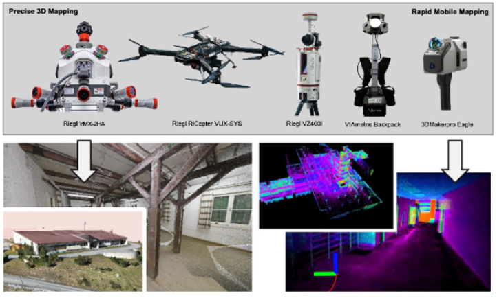
The analytic workflow begins with spatial registration and scene reconstruction (Figure 2), followed by object and surface classification, relation extraction, and state comparison against the reference database. Semantic analysis should identify entities such as walls, doors, stairs, vehicles, debris, extinguishers, hazardous materials indicators, and safe or unsafe passages, but it should also infer higher-level constructs such as hazard zones, access corridors, observation points, and mission bottlenecks. This distinction between objects and operational semantics is crucial. A commander rarely needs object recognition for its own sake; the real value lies in what recognized objects imply for action.
Figure 2: Scanning technologies (top) of the Digital Twin Lab and corresponding 3D objects in indoor and outdoor environments.
Semantic analysis should also remain uncertainty-aware. In emergency contexts, false precision is dangerous. The digital twin must therefore encode confidence, data completeness, and provenance, enabling users to differentiate confirmed findings from tentative inferences. AI-based scene interpretation is valuable here, but only if the results are inspectable and revisable. Rather than claiming autonomous understanding of the emergency scene, SmartResponse frames semantic analysis as a human-supervised process of computational structuring. In that sense, the digital twin becomes a mediating artifact between sensing and decision-making: a shared operational model that can be explored, discussed, updated, and communicated across distributed teams.
This workstream further supports scenario reasoning. Once semantic layers are established, the digital twin can be used to test route alternatives, visualize resource placements, and compare possible tactical options. Such capabilities are consistent with recent arguments that digital twins can support coordinated operations and adaptive response when linked to meaningful visual interfaces and live data (Abrishami & Jayaram, 2025). In SmartResponse, semantic analysis is therefore both representational and prospective: it helps users understand the present state and reason about plausible near-future developments.
XR-BASED DECISION SUPPORT XR-based decision support is the primary interactional embodiment of the SmartResponse digital twin. The purpose of the XR layer is to give remote or hybrid commanders a rapid and embodied understanding of spatial relations that are often difficult to derive from map overlays, radio communication, and fragmented camera feeds alone. Prior literature suggests that immersive technologies can improve comprehension of spatially complex and hazardous situations, but also warns that operational value depends on careful task- oriented design (Beroggi et al., 1995; Zhu & Li, 2021). SmartResponse follows this lesson by treating XR as a structured decision environment rather than as a demonstrator of technological spectacle.
The XR interface is intended to support several key activities: orientation to the scene, inspection of semantic layers, comparison of current and reference states, route analysis, resource allocation, and communication of action- relevant findings. Interface elements may include selectable semantic overlays, viewpoint presets, uncertainty indicators, timeline-based updates, and tools for annotating or sharing recommended actions. Crucially, the interface should enable transitions between overview and detail. Commanders must be able to zoom out for strategic coherence and zoom in for local interpretation without losing context.
A further contribution lies in integrating communication. The value of a digital twin increases when it functions as a shared reference in distributed collaboration. Therefore, the XR environment is not conceptualized as an isolated visualization cockpit but as a collaborative coordination surface from which instructions, marked regions, route suggestions, and risk notices can be transmitted to field teams or linked support displays. Research on immersive systems in disaster contexts highlights the promise of such
The SmartResponse Framework: A Semantic Digital Twin Approach 229 integrated visual communication, especially when used to bridge spatial complexity and team coordination demands (Khanal et al., 2022; Hancko et al., 2025). In SmartResponse, XR-based decision support is successful only if it measurably improves the efficiency and consistency of command reasoning. Accordingly, evaluation will examine not only subjective acceptance but also whether XR-supported users can identify hazards, judge routes, and communicate operational intent more effectively than with conventional fragmented representations.
EMERGENCY-CRITICAL HUMAN FACTORS FOR DESIGN AND BIOSIGNAL-BASED EVALUATION Emergency command is a human performance problem as much as a data problem. Operators must prioritize under uncertainty, maintain attention across multiple channels, regulate stress, and preserve team coordination while the scene evolves. The SmartResponse framework therefore includes a dedicated human factors workstream focused on emergency-critical design requirements and biosignal-based evaluation. The theoretical basis draws on situation awareness, cognitive load, and stress-monitoring research, all of which indicate that high-risk decision contexts can degrade perception, comprehension, and projection if information is poorly structured or if operators are overloaded (Endsley, 1995a; Bakzadeh et al., 2025).
The framework assumes that psychophysiological sensing can provide a complementary window into operator state. Reviews of wearable stress monitoring identify HR, HRV, and EDA as especially relevant physiological biomarkers (Figure 3), while also warning that generalization from laboratory data to real-world conditions remains difficult and context dependent (Vos et al., 2023; Bolpagni et al., 2024). For SmartResponse, this means biosignals should not be treated as infallible ground truth, but as one informative channel among others. Their main role is twofold: first, to evaluate interface designs under realistic demand; and second, to inform adaptive assistance strategies during mission-relevant decision episodes.
A scientifically important distinction is made between retrospective evaluation and real-time support. In retrospective analyses (after action analysis), biosignals can help identify which interface events, task transitions, or information displays coincide with elevated stress or attentional disruption. In real time, cautiously interpreted stress indicators may trigger support adaptations such as reduced visual clutter, prioritization of only mission-critical cues, or temporary recommendation prompts. However, such adaptation must avoid paternalism and annoyance. The design goal is supportive regulation of interface demand, not intrusive monitoring of the commander. Human factors evaluation in the SmartResponse framework therefore combines subjective workload and usability measures, behavioural performance indicators, observational analysis, and biosignal streams. This multimethod approach is needed because emergency performance cannot be validly captured by any single metric. The broader contribution is a design framework in which operator state becomes a legitimate parameter for interface optimization without displacing human agency.
(a) (b)
Figure 3: Wearable biosignal sensor technologies for human factors measurements: (a) HR, HRV, EDA using Polar and EmbracePlus (cognitive-emotional stress, fatigue) and (b) XR headset Meta Quest 3 with inlet eye tracking by Pupil Labs Neon1 (attention, situation awareness).
AI-BASED OPTIMIZATION OF INTERACTION STRATEGIES The SmartResponse concept includes AI not as an autonomous commander but as an optimizing assistance layer for interaction and information management. This distinction is central in safety-critical environments, where opaque automation can undermine trust, coordination, and accountability. Research on human-AI teaming shows that performance gains are not guaranteed simply by adding AI; inadequate transparency and poor shared cognition can reduce communication quality and mutual understanding (Schmutz et al., 2024). Consequently, AI in SmartResponse is constrained by human-centred principles: it should enhance human command, make its rationale inspectable, and remain overrideable. AI-based optimization is envisaged in several forms. One is semantic prioritization, where the system highlights scene elements or changes that are likely to be operationally significant. Another is adaptive interaction support, where the system learns which visualization states, alerts, or navigation shortcuts best fit different tasks and user conditions. A third is recommendation support for route exploration, zone delineation, or information filtering, based on the current state of the digital twin and contextual mission parameters. Importantly, these functions should be explainable. For example, if the system proposes that a corridor is no longer viable, the user should be able to inspect which observations, comparisons, or confidence estimates underlie that suggestion.
The optimization problem is therefore sociotechnical rather than merely computational. It concerns when to intervene, to what extent, and how to present assistance without eroding command responsibility. The system should also avoid automation surprise by preserving consistency and predictability in its behaviour. Human-centred AI science increasingly frames such design as one of augmentation, trust calibration, and workflow fit rather than raw algorithmic accuracy alone (Scharowski et al., 2023; Schmutz et al., 2024). In SmartResponse, AI-based optimization will be explored experimentally through adaptive cueing and role-sensitive information presentation. The expected contribution is a set of design principles for AI 1https://pupil-labs.com/products/vr-ar
The SmartResponse Framework: A Semantic Digital Twin Approach 231 assistance that improve interaction efficiency while respecting the epistemic and organizational realities of emergency command.
EXPLORATORY FIELD TRIALS The proof-of-concept value of SmartResponse ultimately depends on evaluation in ecologically meaningful settings. For this reason, the project foresees exploratory field trials that progressively integrate semantic infrastructure data, incident-time sensing, digital-twin analysis, XR decision support, and human factors instrumentation. These trials are conceived as staged demonstrations rather than definitive randomized effectiveness studies. Their aim is to test feasibility, usability, robustness, and organizational fit under realistic constraints.
Methodologically, the field trials will combine scenario-based exercises, role-specific tasks, observational protocols, system logs, structured debriefings, and selected psychophysiological recordings. Performance indicators may include time to establish an operational picture, correctness of hazard-zone interpretation, route-planning quality, communication consistency, and subjective confidence. Because command support is inherently collaborative, the trials will also examine how the system changes coordination patterns between remote decision-makers and field personnel.
An important question is whether the digital twin becomes a genuinely shared operational reference or remains an additional display used by only one role.
Exploratory trials are especially important for identifying breakdowns that laboratory studies may miss. These include transmission delays, partial reconstructions, conflicts between sensor indications and field reports, discomfort associated with extended XR use, and inappropriate assistance timing. The field context is also where biosignal-based adaptation can be judged for practical legitimacy. A technically accurate stress estimate that is operationally disruptive would not count as success. The project therefore treats field trials as both a validation step and a source of redesign knowledge.
From a scientific standpoint, these trials contribute to translational human factors and emergency informatics. They provide evidence about whether semantically enriched digital twins, immersive interfaces, and adaptive assistance can be integrated into real command workflows with acceptable cognitive and organizational costs. Even negative findings would be valuable because they would clarify boundary conditions for future deployment.
CONCLUSIONS AND FUTURE WORK SmartResponse proposes a comprehensive framework for semantically enriched, XR-mediated, and human-centred support of operational coordination in emergency contexts. The project responds to a persistent gap between the complexity of incident environments and the limited representational power of conventional remote command media. By linking pre-incident infrastructure modelling, emergency-time 3D sensing, semantic digital-twin analysis, immersive decision support, biosignal-informed human
factors evaluation, and explainable AI assistance, SmartResponse seeks to create a more actionable and communicable operational picture.
Future work should expand semantic models for infrastructure vulnerability, route viability, and mission logic, while improving adaptive assistance through explainable, trust-sensitive mechanisms. Longer-term field studies are needed to assess training effects, adoption barriers, and interoperability. Ethical issues of data use, responsibility, and transparency must also be resolved before deployment. SmartResponse is therefore not a finished product, but a scientifically grounded path toward remote decision support that integrates disaster research, immersive analytics, human factors, and AI within one sociotechnical system.
ACKNOWLEDGMENT
This work was partially funded by the SmartResponse project under grant No. FO999905346 of the Austrian FFG KIRAS programme, co-financed by the Austrian Federal Ministry of Innovation, Mobility and Infrastructure (BMIMI) and by the GigaResponse project under grant No. FO0999929426 of the FFG BBA2030:GigaApp programme, co-financed by Austrian Federal Ministry of Economy, Energy and Tourism (BMWET).
REFERENCES
Abrishami, S., & Jayaram, R. (2025). Digital twins and augmented reality for humanitarian logistics in urban disasters: Framework development. Logistics, 9(4), Article 143. https://doi.org/10.3390/logistics9040143 Bakzadeh, R., Joao, K. M., Androulakis, V., Khaniani, H., Shao, S., Hassanalian, M.,
& Roghanchi, P. (2025). Enhancing Emergency Response: The Critical Role of Interface Design in Mining Emergency Robots. Robotics, 14(11), 148. https://doi. org/10.3390/robotics14110148 Beroggi, G. E. G., Waisel, L., & Wallace, W. A. (1995). Employing virtual reality to support decision making in emergency management. Safety Science, 20(1), 79–88. https://doi.org/10.1016/0925-7535(94)00068-E Bolpagni, M., Pardini, A., et al. (2024). Personalized stress detection using biosignals
from wearables: A scoping review. Sensors, 24(10), 3221. https://doi.org/10.3390/ s24103221 Endsley, M. R. (1995a). Toward a theory of situation awareness in dynamic systems.
Human Factors, 37(1), 32–64. https://doi.org/10.1518/001872095779049543 Endsley, M. R. (1995b). Measurement of situation awareness in dynamic systems.
Human Factors, 37(1), 65–84. https://doi.org/10.1518/001872095779049499 Endsley, M. R., & Jones, D. G. (2024). Situation awareness oriented design: Review and future directions. International Journal of Human-Computer Interaction, 40(7), 1487–1504. https://doi.org/10.1080/10447318.2024.2318884 Grandio, J., Riveiro, B., Soilán, M., & Arias, P. (2022). Point cloud semantic
segmentation of complex railway environments using deep learning. Automation in Construction, 144, 104425. https://doi.org/10.1016/j.autcon.2022.104425 Hancko, D., Majlingova, A., & Kačíková, D. (2025). Integrating virtual reality, augmented reality, mixed reality, extended reality, and simulation-based systems into fire and rescue service training: Current practices and future directions. Fire, 8(6), 228. https://doi.org/10.3390/fire8060228
The SmartResponse Framework: A Semantic Digital Twin Approach 233 ISO. (2019). ISO 9241-210:2019 Ergonomics of human-system interaction - Part
210: Human-centred design for interactive systems. International Organization for Standardization. Khanal, S., Alam, O., Puri, V., Ahmad, S., & D. (2022). Virtual and augmented reality in the disaster management technology: A literature review of the past 11 years. Frontiers in Virtual Reality, 3, Article 843195. https://doi.org/10.3389/ frvir.2022.843195 Lagap, U., & Ghaffarian, S. (2024). Digital post-disaster risk management twinning:
A review and improved conceptual framework. International Journal of Disaster Risk Reduction, 110, 104629. https://doi.org/10.1016/j.ijdrr.2024.104629 Scharowski, N. S., Perrig, S. A. C., Svab, M., Opwis, K., & Brühlmann, F. (2023).
Exploring the effects of human-centered AI explanations on trust and reliance. Frontiers in Computer Science, 5, Article 1151150. https://doi.org/10.3389/ fcomp.2023.1151150 Schmutz, J. B., Outland, N., Kerstan, S., Georganta, E., & Ulfert, A.-S. (2024).
AI-teaming: Redefining collaboration in the digital era. Current Opinion in Psychology, 58, 101837. https://doi.org/10.1016/j.copsyc.2024.101837 Steen-Tveit, K., & Munkvold, B. E. (2021). From common operational picture to common situational understanding: An analysis based on practitioner perspectives. Safety Science, 142, Article 105381. https://doi.org/10.1016/j. ssci.2021.105381 Vos, G., Trinh, K., Sarnyai, Z., & Rahimi Azghadi, M. (2023). Generalizable machine
learning for stress monitoring from wearable devices: A systematic literature review. International Journal of Medical Informatics, 173, 105026. https://doi. org/10.1016/j.ijmedinf.2023.105026 Wang, J., Li, H., Xu, Z., & Xie, X. (2023). Semantic Segmentation of Urban Airborne LiDAR Point Clouds Based on Fusion Attention Mechanism and Multi-Scale Features. Remote Sensing, 15(21), 5248. https://doi.org/10.3390/rs15215248 Waring, S., Alison, L., Shortland, N., & Humann, M. (2020). The role of
information sharing on decision delay during multiteam disaster response. Cognition, Technology & Work, 22(2), 263–279. https://doi.org/10.1007/ s10111-019-00570-7 Zhu, Y., & Li, N. (2021). Virtual and augmented reality technologies for emergency management in the built environments: A state-of-the-art review. Journal of Safety Science and Resilience, 2(1), 1-10. https://doi.org/10.1016/j.jnlssr.2020.11.004
LISTED IN THE AHFE DIGITAL BOOKSTORE CATALOGUE
Explore the complete digital volume
Cognitive Computing and Internet of Things
Read this individual research paper free through the original publisher, or explore the full digital proceedings book.
ISBN 978-1-964867-81-6
Explore this ISBN in the AHFE Bookstore ↗Listed in the July 2026 bookstore catalogue; search by ISBN to confirm current availability · Digital book purchase optional