Deborah Bakowski, Lynne Martin, Connie Brasil, Yasmin Arbab, Gregory Costedoat, Stefan Blandin, Charles Walter, Rania Ghatas (2025). Integration and Testing of a UAS Airspace Management System in the Wildland Firefighting Environment. In: Human Factors in Design, Engineering, and Computing. AHFE Open Access, vol. 199, pp. 1298–1309. https://doi.org/10.54941/ahfe1006941
NASA’s Advanced Capabilities for Emergency Response Operations (ACERO) project explores the use of technology to provide additional aerial support in the wildland firefighting environment by extending the use of Uncrewed Aircraft Systems (UAS) into low-visibility conditions to support sustained operations. A key step in enabling extended UAS operations is the integration of an airspace management system into the wildland fire environment to support the planning, deconfliction, and situation awareness of UAS operations. During Spring 2025, ACERO conducted its first field evaluation with live UAS operations to test the prototype Portable Airspace Management System (PAMS), which allows UAS operators to digitally coordinate multiple UAS operations and share real-time information. PAMS is comprised of an airspace management system, derived from the UAS Traffic Management (UTM) system; an air-to-ground digital communications network; and a graphical user interface (GUI) to support situation awareness. In this paper, we present an overview of ACERO’s first field evaluation, including a description of the PAMS technology, UAS flight operations, and how participants used the GUI to build operational volumes. In the Results section, a summary of questionnaire findings is presented to assess how well the GUI supported situation awareness, usability, and ease of use. We also discuss challenges encountered during field testing and their impact on subjective ratings.
Wildland fires can have devastating and far-reaching consequences, including loss of human life, negative health effects, wildlife displacement, ecosystem destruction, and damage to homes and infrastructure, all with significant economic costs. Statistics show that wildland fires are growing in size and intensity. Over the past thirty years in the United States (U.S.), the number of acres affected by wildland fires has increased – in 2024, 8.9 million acres were burned (NIFC, 2024) which is more than double the average acreage burned
Integration and Testing of a UAS Airspace Management System 1299
per year in the 1990s (i.e., 3.3 million acres; Riddle, 2023). In the western U.S. and Alaska, the incidence of large forest fires has increased (USGCRP, 2017) and the wildland fire season has grown longer (Swanston et al., 2016). Furthermore, a 2022 report predicts a global increase in extreme fire events of 14% by 2030 and 30% by 2050 (UNEP, 2022).
Uncrewed Aircraft System (UAS) in Wildland Firefighting Aerial resources, such as tankers and helicopters, are a critical asset in wildland firefighting and provide support for ground crews through water and retardant drops, mapping, and emergency missions. However, because of the risk of losing situation awareness and collision, crewed aircraft operations are limited to flying during daylight hours, when visibility is not hindered by darkness, smoke, or haze (Ellis et al., 2024). Studies show that sustained operations would result in cost savings and a reduction in the number of acres burned (NASA, 2024).
UAS have become a valuable resource in the emergency response domain, including in wildland firefighting where they are used for a variety of tasks. Larger UAS (Type 1/2) can be equipped with thermal imaging equipment to map the fire perimeter, while smaller UAS (Type 3/4), can be used for real-time video capture, locating “hot spots,” and aerial ignition (Bakowski et al., 2024). UAS have the advantage of potentially operating in low-visibility conditions, when crewed aircraft are restricted from flying, and being more maneuverable and less expensive to operate than crewed aircraft. Several reports on the future of wildland firefighting point to the value of utilizing UAS (Wildland, 2023; Executive, 2023).
However, UAS operations face challenges in the wildfire environment. It can be difficult for an operator to develop situation awareness about the airspace – an issue that is compounded in low-visibility and when operating beyond visual line of sight (BVLOS) (Martin et al., 2021). While some UAS operators do have a mechanism for sharing real-time telemetry (i.e., speed, location, altitude), other crews rely solely on verbal radio communications and manual coordination to build situation awareness of the airspace. Degraded communications, due to a lack of communication infrastructure in remote areas, and terrain that occludes ground-to-ground communication can present additional challenges (Yoo et al., 2024).
Advanced Capabilities for Emergency Response Operations (ACERO) To investigate how technology can be used to provide additional aerial support in fighting wildland fires, NASA launched the Advanced Capabilities for Emergency Response Operations (ACERO) research project in 2023. Second Shift Capabilities (SSC), a sub-project of ACERO, focuses on extending aerial support to fill the gaps created when crewed aircraft are unable to fly. SSC aims to enable BVLOS UAS operations in degraded visual environments, such as nighttime – the proverbial “second shift” of the workday – and in other low-visibility conditions (e.g., heavy smoke). A key piece of enabling technology for the Second Shift concept is the integration of an airspace management system into the wildland firefighting
environment for planning, deconflicting, and monitoring the conformance of UAS operations (Xue, 2024; Yoo et al., 2024).
During Spring 2025, ACERO conducted a two-week field demonstration of its first Technical Challenge Level (“TCL-1”) in Salinas, CA. In this paper, we present an overview of the TCL-1 field demonstration, including: An overview of the Portable Airspace Management System (PAMS) which includes the Wildland Fire Service Supplier (WFSS) airspace management system; an overview of the live UAS flight operations conducted during the field demonstration; a description of how participants interacted with the GUI to build their operation, and a summary of the qualitative data collection from the demonstration, including questionnaire responses and feedback collected from participants.
PORTABLE AIRSPACE MANAGEMENT SYSTEM (PAMS) To enable the coordination of UAS operations in the wildland fire environment, software tools and technologies were integrated to create the field-deployable, research prototype Portable Airspace Management System (PAMS).
Airspace Management System: Wildland Fire Service Supplier (WFSS) The first component of PAMS is the airspace management system. The UTM concept introduced a new paradigm for managing UAS operations in low-altitude airspace by using a community-based approach for sharing intent and operating information. In UTM, operators “define” the area in which they plan to operate in the form of four-dimensional (4D) volumes of airspace, delineated by lat/long, altitude, and time. The UTM Service Supplier (USS) ensures that operations are deconflicted and monitors conformance (FAA, 2020). To incorporate an airspace management system into the wildland firefighting environment, ACERO draws on the UTM concept, leveraging UTM’s USS as a basis for the WFSS. Like the USS, the WFSS compares 4D operational volumes submitted by operators to ensure they do not overlap and monitors each vehicle’s conformance to their volume(s).
Air-to-Ground Digital Communication Network Another component of PAMS is the digital communication network used to support information exchange. To address the challenges of the wildland fire environment, the communications network is 1) mobile, wireless, and not reliant on preexisting infrastructure (e.g., cellular), and 2) able to be used in terrain where ground-to-ground communication is occluded. The communication network was established when the Type 1 UAS climbed high enough as to allow the relay radio it carried to make a line-of-sight connection with each radio on the ground. See Fuller et al. (2024) for a description of the communications network concept.
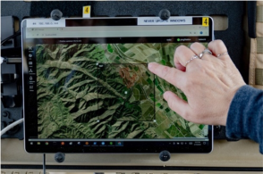
Graphical User Interface (GUI) A third component of PAMS is the GUI (see Figure 1, left) which uses a map- based display with traffic to support the operator’s situation awareness of
Integration and Testing of a UAS Airspace Management System 1301
the airspace and enables the operator to interface with the WFSS. During TCL-1, participants used the GUI to enter the parameters of 4D operational volumes, including location, minimum and maximum altitudes, start time, and duration. Once submitted, the WFSS verified that the volume was deconflicted from other operations (i.e., not overlapping) and was fully within the Temporary Flight Restriction (TFR) boundary. See Arbab (2025) for a full description of the GUI and development process leading up to the TCL-1 demonstration.
PAMS Cases In order to transport the needed equipment and set up PAMS in the field, ruggedized, portable cases were built. The design and functionality of the PAMS cases were informed by the ruggedized, portable UAS Pilot (UASP)- kits developed previously as part of the Scalable Traffic Management for Emergency Response Operations (STEReO) project (Martin et al., 2022; Martin et al., 2023).
As shown in Figure 1 (right), each PAMS case housed: A touchscreen computer on which the GUI was presented and where software such as the WFSS and the Data Processing Tool (DPT) were loaded; a communication network switch that acted as the central point for connecting the multiple devices in the case; a wired router that connected into the network switch and provided the network needed to connect all of the devices within a PAMS case; a radio that supported digital information exchange with other PAMS cases; and an ADS-B receiver that was used to receive position messages from nearby crewed aircraft. The ADS-B messages were fused, shared across PAMS cases by the DPT software, and depicted on the map for operator situation awareness.
Figure 1: Building a volume on the GUI (left) and the field-deployable PAMS case (right).
Each PAMS case also ingested real-time data from the UAS crew’s Ground Control Station (GCS). The flight crew’s GCS was connected, via ethernet cable, to the network switch in the PAMS case in order to supply real-time telemetry data to the WFSS. This real-time telemetry information was shared to other PAMS cases to populate information on the UAS icon’s datatag (e.g., altitude, speed). It was also used to support conformance monitoring. The WFSS compared the vehicle’s location (altitude, position) against the parameters of its 4D operational volume, including its start and end times. If
the UAS was outside of its operational volume (laterally or vertically) or still operating after the End time, the WFSS declared the vehicle non-conforming. The system relies on obtaining real-time telemetry data directly from the GCS because the smaller UAS vehicles do not broadcast via ADS-B.
The integration of the WFSS airspace management system and digital information exchange between PAMS cases enabled the display of all three UAS vehicles and their corresponding operational volumes on the GUI for situation awareness and a common picture of the airspace in which they were operating.
TCL-1 FIELD DEMONSTRATION The TCL-1 field demonstration was conducted in Salinas, CA in the Spring of 2025. The location in the foothills of the Sierra de Salinas mountains was selected, in part, because it offered terrain that made communications challenging. By locating the four UAS launch sites in valleys and atop hills, the terrain helped to occlude ground-to-ground communication between the radios. This allowed for testing and validation of the air-to-ground digital communication network.
UAS Operations A total of four UAS vehicles/crews were onsite for the TCL-1 demonstration. Three vehicles participated in each operational flight: Two smaller Type 3 Alta X UAS vehicles, each operated by a NASA crew, and one larger Type 1 UAS (carrying a relay radio) – which alternated between one of ACERO’s participating industry partners, Overwatch Aero, flying an FVR90 UAS and the SuperVolo flown by a NASA crew. Because the Type 1 UAS carried the relay radio needed to establish the air-to-ground network, it typically launched first, followed by the two Alta X vehicles.
Prior to the start of testing, a Certificate of Authorization (COA) was filed with the Federal Aviation Administration (FAA) for the flight operations to provide ATC awareness about the location and planned altitudes of the UAS operations.
Simulated Wildland Fire Environment: TFR and Fire Perimeter For TCL-1, a simulated Temporary Flight Restriction (11×11 nmi × 4,500 ft high) was created and then shared between PAMS cases and displayed on the GUI. The TFR boundary was utilized by the WFSS system to inform detection of constraint violations; operators received a “Replan Required” message if they submitted a volume that exceeded the TFR boundary. Upon connecting to the communication network at the start of each run, the DPT shared the first fire perimeter with each PAMS case, displayed as a solid red line on the map. During each run, the DPT shared an updated version of the fire perimeter, simulating an update that might be sent to show whether or not the fire is spreading.
Integration and Testing of a UAS Airspace Management System 1303
Roles and Responsibilities In addition to the four flight crews, Flight Operations included a Mission Commander for flight safety who was responsible for ensuring the airspace was deconflicted, a Flight Test Director (FTD) who coordinated flight logistics with researchers, Range Safety Officers, and Visual Observers.
Members of the research team managed the PAMS cases and data collection at each of the UAS launch sites. Each PAMS case was run by a PAMS Case Operator who was responsible for performing the startup procedures, coordinating with their UAS flight crew, and communicating with the PAMS Case Director throughout the entirety of the flight operation. The PAMS Case Director, located separately from the three UAS launch sites, coordinated flight logistics with the FTD. Each PAMS case was also supported by Technology and Radio Specialists, as well as a researcher who collected feedback and administered questionnaires to the participant after each flight operation. An Approver role was fulfilled by one of the Subject Matter Experts (SMEs) to give realism to how operations might be conducted at a real-world fire. Upon verifying that the operational volume encapsulated the vehicle’s flight path, as planned, the Approver provided verbal approval to the PAMS Case Operator via radio.
SMEs from the wildland firefighting community, who have experience operating UAS at wildland fires and each have a background in various wildland fire positions, were onsite and served as the research participants. During flight operations, the SMEs worked closely with the PAMS Case Operators as they interacted with the Operator GUI to input, submit, and modify the operational volumes, and as they utilized the map display for situation awareness. When a SME was not available for a flight operation, a member of the UAS flight crew, if available, served as the participant and engaged with the GUI.
Functional Tests of the WFSS Three functional tests were incorporated to validate the WFSS functionality. Overlapping Volumes (Conflict): The PAMS Case Operator guided the SME to create a volume that intersected (overlapped) another operation’s volume. Upon submitting the overlapping operation, the WFSS returned a “Conflict with [callsign]; Replan Required” message displayed in the GUI. The participant used the “Modify” function to adjust the location of the volume and resubmit the corrected operation to the WFSS. TFR Boundary: With guidance from the PAMS Case Operator, the SME created a volume partially or fully outside of the TFR boundary, either laterally (i.e., to the side of the TFR) or vertically (i.e., above the ceiling of the TFR). Upon submitting the operation, the WFSS returned a “Conflict with TFR; Replan Required” message displayed in the GUI. The participant used the “Modify” function to adjust the location of the volume and resubmit the corrected operation to the WFSS.Non-Conforming Operations: To explore non-conforming operations, the research team closely coordinated with the UAS flight crew to safely deviate from their planned flight operation. During flight, the UAS crew briefly operated their vehicle outside of their operational volume. When
one’s own operation goes non-conforming, the operational volume and UAS vehicle icon are displayed in orange on the GUI, an audio alert is played, and an alert banner is displayed on the map (e.g., “[Callsign] Non-Conforming; Outside of volume laterally.”) Connectivity Scenario: In addition to the three functional tests, a connectivity scenario was incorporated where PAMS case users were instructed to submit their operation prior to the Type 1 UAS launching – that is, prior to the digital communication network being established. The purpose of this exercise was to demonstrate the value of information sharing between PAMS cases. That is, without information sharing between PAMS cases, the local WFSS did not have knowledge of other operations to verify deconfliction, PAMS case users did not have a common operating “picture” of the airspace, and the Approver did not have full situational awareness of the operations, leaving the PAMS case user to verbally describe the location of their volume to the Approver over the radio.
DATA COLLECTION Flight Operations and Functional Tests
A total of 11 operational runs were completed during TCL-1, with each run lasting, on average, 1 hr and 14 min. The duration of the runs varied due to a number of factors including planned tasks, such as carrying out the various WFSS functional tests, as well as unplanned factors, such as technical issues with the PAMS cases, UAS mechanical issues, and weather (e.g., low cloud ceiling).
The TCL-1 demonstration afforded the SMEs/crew members the opportunity to interact with the GUI in a real-world setting with live flight operations. Across the 11 operational runs, a total of 40 operational volumes with location, altitude, and duration parameters were built in the GUI, with 37 of the operations eventually being advanced to the “Activated” operational state when a UAS vehicle launched.
With respect to the functional tests for validating the WFSS system, three of the 11 runs were considered “nominal” in that no functional tests were carried out. During each of the remaining eight runs, participants carried out at least one, and sometimes two, of the planned functional tests (i.e., overlapping volumes, TFR boundary, non-conformance, and the connectivity scenario). For example, during these eight runs, a total of 19 overlapping operations and 20 TFR boundary violations were submitted by the participants and subsequently detected by the WFSS to validate system capabilities. Numerous instances of non-conformance during flight (with some planned and others unintended) were also logged.
Qualitative Results In addition to providing feedback and comments to the research team as they engaged with the GUI, participants also completed post-flight questionnaires after each run and a post-study questionnaire at the end of the demonstration. Because PAMS is intended to support users (e.g., UAS operators and possibly an “Approver” role) who have to focus on their primary mission and other
Integration and Testing of a UAS Airspace Management System 1305
tasks, the GUI needs to support the user’s situation awareness and ease of use.
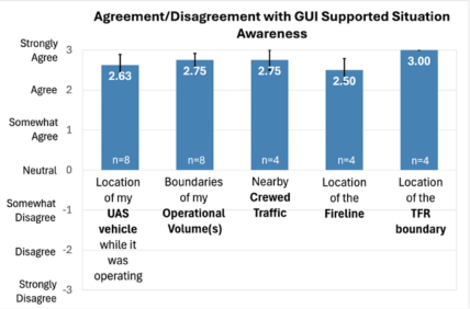
Supporting Situation Awareness Using a 7-point scale on the post-run questionnaires, participants were asked to rate their agreement/disagreement with “The GUI supported my Situation Awareness of the: a) Location of my UAS vehicle while it was operating, b) boundaries of my operational volume(s), c) nearby crewed traffic, d) location of the fireline, and e) location of the TFR boundary.” As shown in Figure 2, the mean rating for each of the five display elements between Agree and Strongly Agree. Individual responses ranged between Somewhat Agree and Strongly Agree (i.e., no Neutral or Disagree ratings).
Figure 2: Mean situation awareness ratings of five map elements. Error bars = +/– 1 S.E.
When asked how the GUI could support additional situation awareness, participants suggested more vehicle telemetry information (e.g., directional heading arrow), weather/wind information, and the functionality to add range rings around a UAS operation to detect crewed aircraft, like the UASP- kit (Martin et al., 2022; Martin et al., 2023). In feedback and comments, several participants also expressed a concern about maintaining the situation awareness when two display elements overlap on the map – that is, ensuring that the fireline or an aircraft icon remains visible when overlaid by an operational volume.
In a multiple choice question on the post-study questionnaire, participants were asked, “What aspect of the GUI helped to enhance situation awareness?” All seven respondents agreed that seeing UAS vehicles, their operational volumes, and crewed aircraft were the most important display elements for enhancing situation awareness. The respondents said that traffic information supports situation awareness because it “aids in making safe/informed decisions,” “helps increase the separation of aircraft,” and “helps to create a mental model of what’s actually happening [in the airspace].”
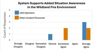
Using a 7-point scale on the post-study questionnaire, participants were asked to rate their agreement/disagreement with two statements, “This
system would support added situation awareness: a) for UAS operators and b) for other fire personnel in a real-world wildland fire environment.”
As shown in Figure 3 (left), the responses ranged between Neutral and Strongly Agree and generally suggest agreement that the system would help support situation awareness for both roles in the real-world.
One participant who responded Somewhat Agree cited the need for the system to be “packaged in a way that it could be easily used.” This comment may reflect the need for additional functionality to better support the Approver role, or possibly, the need to simplify the PAMS setup process (as a research prototype system, NASA team members set up the PAMS case and configured the GUI before participants began engaging with the GUI to build their operations).
Overall Usability Using a 7-point scale on the post-run questionnaires, participants were asked to rate the “Overall Usability of the GUI.” As shown in Figure 3 (right), all eight respondents selected High (n=5) or Very High (n=3). Participants said that usability could continue to be improved by increasing the saliency of notifications/alerts, adding a profile (side) view to the map, and by providing more direct access to information about UAS operations (e.g., minimum and maximum altitudes of volumes).
Figure 3: System supports situation awareness in the real-world wildland firefighting environment (left) and overall usability of the GUI (right).
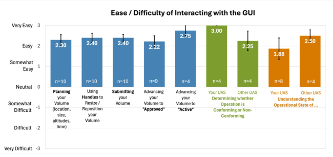
Ease of GUI Interactions On the post-run questionnaires, participants were asked to rate the “ease/difficulty of interacting with the GUI” using a 7-point scale. As shown in Figure 4, participants rated eleven interactions with the GUI from entering the parameters to build their volume to closing the operation after the UAS landed. With the exception of one interaction, the mean rating was between Easy and Very Easy. Overall, these responses point to the GUI being relatively easy to use. The participant who selected Somewhat Difficult in response to understanding the operational state of their UAS operation indicated that a legend or key is needed to understand the color-coding of each operational state. Practice / exposure time to the GUI may also be a possible factor in why some participants selected Somewhat Easy rather than Easy. For example, one participant commented, “The UI is modern and easy to navigate once you learn where things are.”
Integration and Testing of a UAS Airspace Management System 1307
Figure 4: Mean ease/difficulty ratings of GUI interactions. Error bars = +/– 1 S.E.
Impact of Delayed or Missing Information on GUI During some operational runs, participants observed that updates about other UAS operations (i.e., state changes, vehicle location) were not displayed on their map as quickly as expected. At times, it appeared that there was a delay in receiving updated information from other PAMS cases. Similarly, not all of the crewed traffic was shared and displayed across all of the PAMS cases, as intended. While the root causes of these issues are being investigated, it is evident that they impacted participants’ experience with the system.
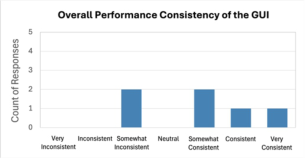
For example, on the post-study questionnaire, users were asked to rate the “overall performance consistency” of the GUI using a 7-point scale. As shown in Figure 5 (left), responses ranged between Somewhat Inconsistent and Very Consistent. When they selected less than Consistent, participants cited the display updating more slowly than expected and incomplete ADS-B traffic on the map. When asked, “What aspect of the GUI was frustrating?” one respondent provided the following response, “Bad ADS-B info creates uncertainty/affects decision making.”
Figure 5: Overall performance consistency (left) and timeliness of information on the GUI (right).
Using a 7-point scale on the post-study questionnaire, users were asked to rate the “timeliness of information shown in the GUI.” As shown in Figure 5 (right), responses ranged between Somewhat Not Timely to Always Timely. Participants again cited map information not updating as quickly as expected. Three respondents also commented that the timing of receiving information on the GUI was “inconsistent.” One participant mentioned the safety implication of not having “immediate information about non- conforming operations” due to this issue.
CONCLUSION
As the first in a series of technology demonstrations planned by the ACERO project, TCL-1 successfully demonstrated the research prototype PAMS, developed to support the digital coordination of UAS operations and support situation awareness. Functional tests validated the WFSS and positive feedback was received from participants about their interactions with the PAMS GUI. ACERO’s second technical challenge level (TCL-2) will focus on expanding the functionality of the WFSS and providing more decision support information to the UAS operator (e.g., terrain, fire information, and ground operation information).
REFERENCES
Arbab, Y., Brasil, C. L., Martin, L., Costedoat, G., Blandin, S. A., Walter, C.
M., & Bakowski, D. L. (2025). Development of a Graphical User Interface for the Advanced Capabilities for Emergency Response Operation’s Portable Airspace Management Concept. AHFE International Conference Hawaii Edition, Honolulu, HI, December 8–10, 2025. Bakowski, D. L., Martin, L., Dustin, G., & Mariano, C. (2024). Incorporating UAS Traffic Management into Wildland Firefighting Operations: Initial Findings of Subject Matter Expert Interviews. 43rd AIAA DATC/IEEE DASC, 3009, San Diego, CA, Sept. 29–Oct. 3, 2024. https://doi.org/10.1109/DASC62030.2024.10749240 Ellis, K., Johnson, M., Neogi, N., & Homola, J. (2024). NASA Research
to Expand UAS Operation for Disaster Response. 34th Congress of the ICAS, Florence, Italy, Sept. 9–13, 2024. https://ntrs.nasa.gov /api/citations/20240007804/downloads/ICAS-2024-SWS-ACERO-v1_3.pdf Executive Office of the President, President’s Council of Advisors on Science and Technology. (2023). Modernizing Wildland Firefighting to Protect Our Firefighters. https://bidenwhitehouse.archives.gov/wp- content/uploads/2023/02/PCAST_Wildfires-Report_Feb2023.pdf Federal Aviation Administration (FAA). (2020). UTM Concept of Operations, Version 2.0. Federal Aviation Administration, U. S. Department of Transportation, Washington, D. C. https://www.faa.gov/sites/faa.gov/files/2022- 08/UTM_ConOps_v2.pdf Fuller, D., Elder, X., & Sheehe, C. (2024). Communications System Concept of Operations (ConOp) for Supporting Second Shift (SS) Operations. National Aeronautics and Space Administration (NASA) Glenn Research Center, Cleveland, OH. https://ntrs.nasa.gov/api/citations/20240007754/downloads/20240007754%20 DOC.pdf Martin, L., Arbab, Y., & Mercer, J. (2021). Initial Exploration of STEReO
(Scalable Traffic management for Emergency Response Operations) System User Requirements for Safe Integration of Small UAS. 40th IEEE/AIAA DASC, San Diego, CA, October 3–7, 2021. http://doi.org/10.2514/6.2022-4003 Martin, L., Arbab, Y., Roberts, L., Mercer, J., Walter, C., McCarty, W., & Sheehe, C. (2022). Developing an Unmanned Aircraft System Pilot Kit (UASP-kit) for Wildland Fire UAS Operators. AIAA AVIATION Forum, 2022–4003, June 27– July 1, 2022, Chicago, IL. https://corescholar.libraries.wright.edu/isap_2023/48 Martin, L., Roberts, L., Mercer, J., Arbab, Y., Walter, C., McCarty, W., Sheehe, C., &
Fuller, D. (2023). Initial Testing of the Uncrewed Aerial System Pilot Kit (UASP- Kit) in Operational Settings. 22nd ISAP, May 31–June 3, 2023, Rochester, NY. https://corescholar.libraries.wright.edu/isap_2023/48
Integration and Testing of a UAS Airspace Management System 1309
NASA. (2024). Wildland Fire Management Interim ACERO ConOps v1.0. National Interagency Coordination Center (NIFC). (2024). Wildland Fire Summary and Statistics Annual Report 2024. https://www.nifc.gov/sites/default/files/NICC/2- Predictive%20Services/Intelligence/Annual%20Reports/2024/annual_report_ 2024.pdf Riddle, A. A. (2023). Wildfire Statistics. Congressional Research Service, In Focus, IF10244, Version 69. Retrieved June 1, 2023. https://crsreports.congress.gov/product/pdf/IF/IF10244 Swanston, C. W., Janowiak, M. K., Brandt, L. A., Butler, P. R., Handler, S.
D., Shannon, P. D., Derby Lewis, A., Hall, K., Fahey, R. T., Scott, L., Kerber, A., Miesbauer, J. W., & Darling, L. (2016). Forest Adaptation Resources: Climate change tools and approaches for land managers, 2nd ed. US Department of Agriculture, Forest Service, Northern Research Station. https://www.climatehubs.usda.gov/approach/restore-or-maintain-fire-fire- adapted-ecosystems-0 United Nations Environment Programme (UNEP). (2022). Spreading like Wildfire: The Rising Threat of Extraordinary Landscape Fires. https://www.unep.org/resources/report/spreading-wildfire-rising-threat- extraordinary-landscape-fires USGCRP. (2017). Climate Science Special Report (CSSR): Fourth National Climate Assessment, Volume I. U. S. Global Change Research Program, Washington, DC. https://www.nrc.gov/docs/ML1900/ML19008A410.pdf Wildland Fire Mitigation and Management Commission. (2023). Wildland Fire Mitigation and Management Commission: Aerial Equipment Strategy Report. https://www.usda.gov/sites/default/files/documents/wildfire-commission- aviation-report.pdf Xue, M. (2024, November). ACERO: Advanced Capabilities for Emergency Response Operations. National Aeronautics and Space Administration (NASA) presentation. https://ntrs.nasa.gov/api/citations/20240014756/downloads/20240014756 _ACERO_Overview.pdf Yoo, H-S., Monheim, S., Martin, L., & McSwain, R. (2024). Advancing Wildland
Fire Response with NASA’s Second Shift Capabilities. 43rd AIAA DATC/IEEE DASC, AIAA-2024–3286, San Diego, CA, September 29–October 3, 2024. https://doi.org/10.1109/DASC62030.2024.10749113
LISTED IN THE AHFE DIGITAL BOOKSTORE CATALOGUE
Explore the complete digital volume
Human Factors in Design, Engineering, and Computing
Read this individual research paper free through the original publisher, or explore the full digital proceedings book.
ISBN 978-1-964867-75-5
Explore this ISBN in the AHFE Bookstore ↗Listed in the July 2026 bookstore catalogue; search by ISBN to confirm current availability · Digital book purchase optional