Alexandre Cardoso, Gerson Lima, Edgard Afonso Lamounier, Andre Luis De Araujo, Arnaldo Rosentino, Ana Cristina De Freitas Marotti, Ricardo Oliveira Rocha (2023). Building Information Modeling approach for Design and Operation of Electrical Substations Integrated with Geographic Intelligence Systems (GIS). In: Human Factors in Software and Systems Engineering. AHFE Open Access, vol. 94, pp. 195–204. https://doi.org/10.54941/ahfe1003949
In the context of the Brazilian electrical sector, there are no references regarding the application of BIM (Building Information Modeling) and GIS (Geographic Information System) in construction and maintenance of Electric Power Substations. Thus, this work proposes the integration of these technologies, since previous experiences in other engineering fields have shown promising advances that could be useful for the management and maintenance of the electrical power market. By associating these technologies, it is possible to obtain a more accurate mapping of the information related to the assets, arrangements, cabling, electronic components, etc. Moreover, in order to have this integration working properly, it is required to also provide a three-dimensional geometric database of the entire set of the electric power substation active components. In fact, the insertion of one model into a particular point of the substation project allows constructive, operational and maintenance information. Therefore, by combining BIM and GIS in the modeled families, it is possible to obtain more consistent information during the construction or maintenance phase. This will provide advantages in decision making, resources within the corporate communication and a better understanding of the environment related to an electrical energy substation. Additionally, the location conditions and the surroundings of the substation would be more precise and pertinent since the components of the substation will become geo-referenced. The association between these two platforms allows a more intuitive overview of the project, making them adherent to the planning, design, construction, operation, preventive and corrective maintenance. So, when applying these tools together, the company will obtain results almost immediately, since all managing features will be accessed through only one integrated information database. This proposal presents the very first results of the integration of BIM and GIS, in the context of a Brazilian electric company - Furnas Energy. Implementation results of the solution in the context of substations of the company are discussed and shows the availability of reducing construction/maintenance costs, alteration planning, logistics, prevention of possible accidents and also the possibility of updating information in real time.
The rising of power demand in the world means that there is a need to build new electric power substations or upgrade the existent ones. This is a chal- lenge to AEC (Architecture, Engineering, and construction) Industry, since it is necessary to design and manage more efficiently (Kokuros and Eyrich, 2016). Hence, a possible way to do better management is a Building Informa- tion Modeling (BIM) methodology integrated with Geographic Intelligence Systems (GIS).
A possibility to do better management of Design on Substation is involved in the project’s multi- discipline sectors (Akintoye and McIntosh, 2000). As a result of this collaborative work, the professionals and the Companies would have a better result in the Design and Construction (Manzione, 2013).
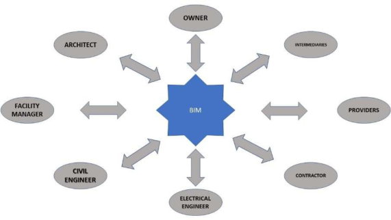
However, a substation construction or maintenance is a complicated pro- cess, which requires important analysis before the beginning of any design to find an optimal solution, satisfying required standards (Kokuros and Eyrich, 2016). Afterward, it is interesting to adopt strategies with BIM for the development of new electrical substations. Carrying these strategies, it is important to highlight that a good substation design can be supported by teamwork with multi-disciplinary capabilities working from different branches with BIM methodology (see Figure 1).
In addition, it is possible to associate BIM with GIS for a complete mana- gement system, as has already been demonstrated in urban management (Almeida and Andrade, 2015). Thus, it is easy to have more efficiency in management when these tools are applied together.
However, as opposed to Architecture and Civil Engineering, in the national electricity sector, there are no references regarding the application of BIM and GIS in construction and maintenance projects of electric power substations. Therefore, this work deals with the integration of these technologies, which will point to innovative results in engineering, maintenance, and operation of Electric Power Substations.
Figure 1: Multi-disciplinary teamwork. (Adapted from Kokuros and Eyrich, 2016.)
Building Information Modeling Approach for Design and Operation 197
This switching between the BIM and GIS methodology is only possible due to the collaborative characteristics of the BIM model (Almeida and Andrade, 2015). Although this application already exists in the field of Civil Engine- ering, it is necessary to study more in-depth how to apply it to the electric energy distribution sector. By associating these technologies, a map with high precision of the information related to the assets, arrangements, cabling and components of an electric power substation may directly influencing the logi- stics of equipment and maintenance teams. This reduces costs for reworking substation projects, facilitating regulatory and approval procedures, integra- tion with services, monitoring, supervision and inspection, value generation, and cost reduction with integrated procedures.
BUILDING INFORMATION MODELING (BIM) According to Autodesk (2018), BIM is an intelligent 3D model-based process that gives AEC professionals the insight and tools to plan more efficiently, design, construct and manage buildings infrastructure. This model brings a construction database, being possible to all branches involved in the planning and execution checking information regarding HVAC (Heating, Ventilating and Air Conditioning) (Casey, 2008).
BIM Methodology allows an information to be shared among multi- disciplinaries teams, creating a Virtual Environment (VE) 3D of the blueprint. This VE allows the updating of the constructive information of the building (Autodesk, 2018).
Therefore, with this collaborative working environment allows easier iden- tification of critical factors in the planning phase, enabling better making decision in the design process, creating a 2D blueprint associated to a 3d model (Vasconcellos and Hernandes, 2015). A BIM software gives the entire 3d model in all its phase and in final integrated form, so there is a complete overview of planning and implementation and the output documentation has high quality because it provides insight into all elements necessary to making the decision.
Thus, by systematically applying the definitions and parameters to be stan- dardized, it is possible to create a digital library with BIM substation objects for the use of several substation projects, making the digital models applied in these projects exceed a simple 3D information (CATARINA, 2014). The- refore, BIM is a Computer Supported Cooperative Work (CSCW), capable to generate collaborative models with simulation information, planning, design, construction and operation (Takim and Harris and Nawawi, 2013).
GEOGRAPHIC INFORMATION SYSTEM (GIS) GIS is a computerized database management system, which is capable to gather, store, recover, analyze, and display georeferenced information (Sul- livan et al., 2004). With the huge increase of service demands in the AEC Industry, it requires an improved way of information visualization to have a better making decision (Song et al., 2017). Thus, GIS has already presented
itself as a great tool for urban management (Almeida and Andrade, 2015; Hijazi et al., 2018).
Geospatial information can be analyzed to determine the geographic loca- tion of predetermined attributes and their relationships to the regions of interest pointed out. With the use and quantification of these points of inte- rest, it is possible to predict how a specific area changes throughout a timeline (Esri, 2018).
The geographic information system can be integrated into a database, which results in an intelligent program that analyzes the behavior of the area of interest in a more objective and summarized way, thus presenting infor- mation in the form of a map oriented more clearly to the operators and users of the system. To optimize the service provided and to increase the quality of the product, GIS can assimilate all the parameters of the real environment into a single virtual model and, when associated with another platform that supports the map, make changes and simulations according to the requested project (Irizarry, Karan and Jalaei, 2013).
After defining the territory and constituting a sketch of the project to be implemented, the GIS performs a calculation of the polygons, conferring the possibility of its execution by means of a geographical code, which, in turn, can be interpreted by several BIM software.
By associating GIS data with three-dimensional (3D) models, all movement and organization of the Virtual Environment are progressively simulated. This correlation is possible because GIS analyzes the objects and points of interest that already exist in the environment in a more abstract way, ope- ning the door to the entrance of another system that would construct a Virtual Environment on the real as an attachment, or be an intelligent platform that has the ability to model the VE on the mapping created (Peleg and Pliskin, 2004).
BIM AND GIS INTEGRATION (GEOBIM) BIM is associated to this aspect, complementing the service provided by the GIS, which has a focus on external modeling, such as areas of greater magni- tude, to increase a physical project on the observed region through internal focus modeling, such as buildings (Irizarry and Karan, 2012). To develop a BIM-GIS association, GeoBIM, it is essential that the benefits of both tech- nologies be evidenced in a single comprehensive model: GIS that creates from existing objects, and BIM that creates with intelligent constructs with information (Peleg and Pliskin, 2004). It is also necessary to highlight the incompatibilities that may hinder the creative process, but can be interpreted as an association of the boundaries of the two technologies (see Table 1).
An important aspect to consider in the GIS-BIM association is the Photo- grammetric Data Acquisition, which is the capture of a series of photographs of the object or environment to create a 3D model. Once created such model, it is necessary to georeference it to associate it with the real-world coordina- tes. Georeferencing involves aligning the model with geospatial data, such as GPS coordinates or existing GIS data. This step ensures that the virtual model is accurately positioned in relation to the geospatial context. So, GeoBIM will
Building Information Modeling Approach for Design and Operation 199
Table 1. Incompatibilities of BIM and GIS.
Table available in the original PDF paper.
GIS BIM Modeling Environment Focused on positioning and external environment.
Focused on internal environment. Reference System
BIM objects have your own coordinate system.
Geospatial Data been georeferenced. Objects are defined in physical world with global coordinate system.
Create in a large scale with a bigger Level of Detail.
Sketch Detailing Creates from a preexisting object. It covers a larger area with lower level of detail and on a smaller scale.
Application Urban area Unique units and their attributes, such as buildings. 3D Models Used to be limited in a 2D model Use a 3d Model rich in detail.
combine geospatial information and building information modeling (BIM), allowing for the visualization and analysis of buildings and infrastructure in a geospatial context.
Application for Power Systems Projects To illustrate the application of GIS and BIM integration in electrical systems, we highlight the experience gained from a research and development pro- ject carried out by Furnas in collaboration with the Federal University of Uberlândia. The focus of this project was the Mascarenhas de Moraes power plant/substation (MMO) located in Furnas, which served as the study object.
In this endeavor, the integration of BIM elements generated from the mode- ling of the substation and hydroelectric plant equipment was crucial. These elements were seamlessly integrated with the corresponding classes of fea- tures within the Furnas Assets Geographic Information System (GisFurnas). This integration enabled the geographical identification and spatial distri- bution of key structures present within the facility, including transformers, disconnectors, instrument transformers, circuit breakers, the dam, water collection and supply systems, the powerhouse, spillway, and more. Furth- ermore, it encompassed the identification and representation of the primary components constituting these structures.
The project employed a strategic approach to organize technical infor- mation in a structured manner using a digital model, which facilitated interaction with the components and structures. It also provided the capa- bility to extract and analyze their characteristics. This approach aligns with the growing trend of utilizing digital twins, where technical information is organized and structured digitally to replicate and simulate real-world assets.
The method employed to visualize BIM data within GIS involves the direct reading of BIM files in Revit format (.rvt) using ArcGIS Pro. These files are
published as services within the ESRI cloud, provided they are georeferenced, enabling the three-dimensional representation of equipment along with all the information contained in the BIM file.
The successful implementation of this methodology has been demonstrated through the representation of Mascarenhas de Moraes power plant/substa- tion elements in BIM format within FURNAS’ ArcGIS Online. Layers are seamlessly added in ArcGIS Pro by establishing a connection to the Autodesk Construction Cloud environment in Furnas. This connection is established using a native resource within ArcGIS Pro, allowing access to a version of the BIM model stored in a folder structure within Furnas’ Construction Cloud.
Once the connection to the Autodesk Construction Cloud in Furnas is established, ArcGIS Pro gains access to the BIM models, facilitating the cru- cial next step of integration. This involves publishing the BIM model within Furnas’ GIS infrastructure, specifically in ArcGIS Online, ensuring seamless integration between the BIM and GIS platforms.
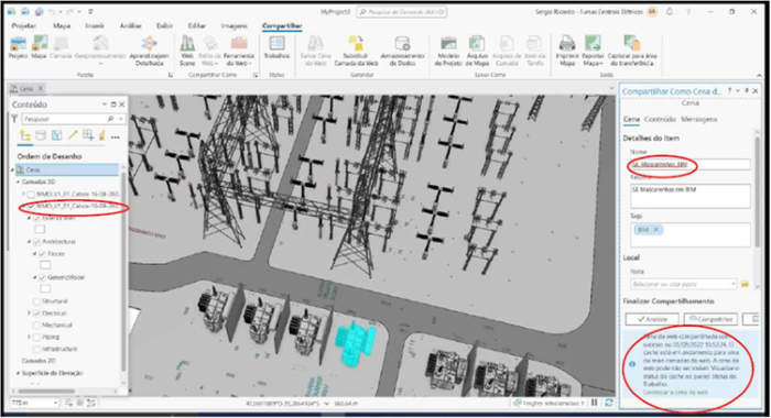
Publication of BIM Model in the Furnas GIS Environment (ArcGIS Online) After establishing the connection, the subsequent action involves publishing the BIM model of the equipment within the Furnas cloud GIS environment, specifically ArcGIS Online. This is accomplished from within ArcGIS Pro by creating a web scene (3D service) in the Furnas cloud GIS environment, utili- zing the platform’s native resources. This strategy offers the significant benefit of not requiring any coding or customization. Figure 2 illustrates the publi- cation of the BIM model of the Mascarenhas de Moraes substation within Furnas’ ArcGIS environment.
Figure 2: Publication of the BIM model (Revit) for SE Mascarenhas on ArcGis OnLine in Furnas.
Building Information Modeling Approach for Design and Operation 201
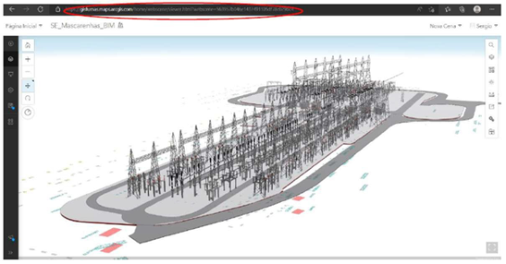
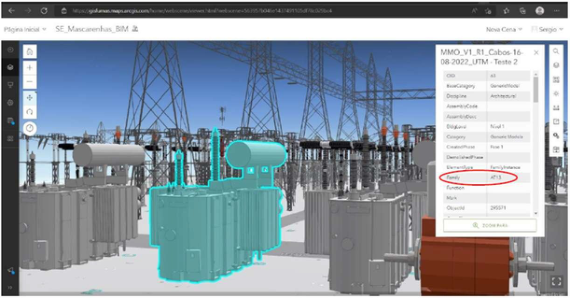
Access of BIM Model at Furnas GIS Environment (ArcGIS Online) Once completing the publication stage of the BIM model as a service within Furnas’ cloud GIS environment (ArcGIS Online), the BIM model becomes readily accessible and navigable in the web interface. This enables seamless interaction with the equipment included in the model, facilitating the identifi- cation of geometries and attributes associated with each piece of equipment. The attributes are established during the initial creation of the models. Figures 3 and 4 depict the BIM model of the SE MMO, highlighting both the navi- gation within the model and the access to equipment attributes in the MMO substation BIM model within Furnas’ ArcGIS Online platform.
As team members collaborate and address issues within Autodesk Constru- ction Cloud, the relevant information is automatically shared and visible to stakeholders in GeoBIM. The effectiveness of this approach has been demon- strated through successful outcomes thus far. To establish communication between the GIS feature and the corresponding Revit file within the Auto- desk cloud, the initial step involves publishing the GIS features on ArcGIS
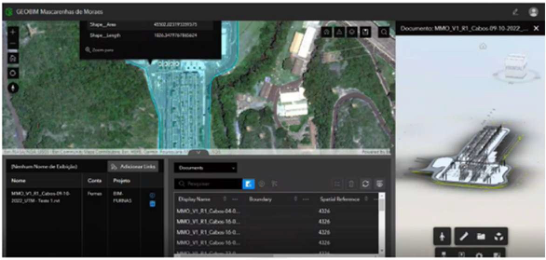
Figure 3: BIM model (Revit) from SE Mascarenhas accessible on ArcGis OnLine in Furnas.Figure 4: Navigation and access to the equipment attributes of the BIM model (Revit) of SE Mascarenhas in ArcGis OnLine of Furnas.Figure 5: GEOBIM application from FURNAS representing SE Mascarenhas de Moraes.
Online. Once the association between the GIS features and Revit files has been established, the GEOBIM application can be configured and saved for availability in either ArcGIS Online or ArcGIS Enterprise. Figure 5 empha- sizes the Furnas GEOBIM application, representing the Substation MMO, within the context of this process.
CONCLUSION
The integration between BIM and GIS is already consolidated in Architecture and Civil Engineering, and it is possible to evaluate advantages in urban and team management as proven by Manzione (2013), Almeida and Andrade (2015). In fact, these tools applied together make it easier to take decisions.
Therefore, when applying this new project model, it is aimed to obtain a better communication among those involved in the works of electric power substations to facilitate a better pricing, reduction of rework, reduction of costs, a quantification of more precise material, better documentation and better planning of preventive, corrective and predictive maintenance. Taking off more efficiently the maintenance teams, since the assets in fields will be georeferenced. The approaches described for integration, utilizing native resources from ESRI and Autodesk platforms, offer optimal practices for inte- grating BIM and GIS in the creation of digital asset models (digital twins). These methodologies enable the representation of civil, electromechanical, and dam safety elements modeled in BIM, which are subsequently incorpora- ted into the GIS environment through the establishment of one-to-one classes. Through geometric and parametric representations, these methodologies pro- vide comprehensive information about the elements, encompassing project details, various levels of information (LODs) derived from project phases, operational and maintenance parameters, as well as asset management data. The practical application of these approaches, demonstrated through the Mascarenhas de Moraes substation models, provides a holistic view of all relevant information associated with the models. This includes design spe- cifications, LODs, operational details, and asset management information, contributing to a comprehensive understanding of the assets.
Building Information Modeling Approach for Design and Operation 203
ACKNOWLEDGEMENTS
The authors express their gratitude to ELETROBRAS/FURNAS and ANEEL for their support through the Research and Development (R&D) project titled “Development of a Methodology Using the BIM (Building Information Modeling) Concept Applied to Substation Projects Integrated with Geogra- phic Intelligence System (GIS),” to FAPEMIG (Minas Gerais State Research Support Foundation), CAPES, and CNPq for the financial support in resea- rch and the teams of the Virtual and Augmented Reality Research Group at the Federal University of Uberlândia (GRVA/UFU).
REFERENCES
Akintoye, A., McIntosh, G., & Fitzgerald, E. (2000). A survey of supply chain collaboration and management in the UK construction industry. European journal of purchasing & supply management, 6(3-4), 159–168. Almeida, F., & Andrade, M. (2015). A Integração entre BIM e GIS como ferramenta
de gestão urbana. VII Encontro de Tecnologia de Informação e Comunicação na Construção (TIC 2015), Recife. Casey, M. J. (2008, October). Work in progress: How building informational modeling may unify IT in the civil engineering curriculum. In Frontiers in Education Conference, 2008. FIE 2008. 38th Annual (pp. S4J-5). IEEE. AUTODESK (Esta- dos Unidos). BIM 360 Design: Revit worksharing and design collaboration softw- are. 2018. Disponível em: <https://info.bim360.autodesk.com/bim-360-design>. Acesso em: 19 dez. 2018. CATARINA, S. (2014). Caderno de Apresentação de Projetos em BIM. Santa
Catarina: Governo do Estado de Santa Catarina. Esri and Autodesk— What’s Next? (2018, February 01). Retrieved December 20, 2018, from Esri and Autodesk— What’s Next? Esri. (2018). What is GIS? | Geographic Information System Mapping Techno-
logy. Retrieved December 27, 2018, from https://www.esri.com/en-us/what-is- gis/overview. Geocoordinated BIM Modeling Benefits Build and Operate Projects.” Between the Poles, Geoff Zeiss, 26 Oct. 2017, geospatial.blogs.com/geospatial/substation- design Glinka S (2022) Cross-sectional SWOT Analysis of BIM and GIS Integration. Geo-
matics Environ Eng 16:157–183. https://doi.org/10.7494/geom.2022.16.3.157 Hijazi, I., Donaubauer, A., & Kolbe, T. (2018). BIM-GIS Integration as Dedicated and Independent Course for Geoinformatics Students: Merits, Challenges, and Ways Forward. ISPRS International Journal of Geo- Information, 7(8), 319. Irizarry, J., & Karan, E. P. (2012). Optimizing location of tower cranes on constru-
ction sites through GIS and BIM integration. Journal of information technology in construction (ITcon), 17(23), 351–366. Irizarry, J., Karan, E. P., & Jalaei, F. (2013). Integrating BIM and GIS to improve the visual monitoring of construction supply chain management. Automation in Construction, 31, 241–254. Kokorus, M., Eyrich, W., & Zacharias, R. (2016, May). Innovative approach
to the substation design using Building Information Modeling (BIM) techno- logy. In Transmission and Distribution Conference and Exposition (T&D), 2016 IEEE/PES (pp.1–5). IEEE. Liu X, Wang X, Wright G, et al (2017) A State-of-the-Art Review on the Integration of Building Information Modeling (BIM) and Geographic Information System (GIS). ISPRS Int J Geo-Information 6:53. https://doi.org/10.3390/ijgi6020053
Manzione, L. (2013). Proposição de uma estrutura conceitual de gestão do processo de projeto colaborativo com o uso do BIM (Doctoral dissertation, Universidade de São Paulo). Mijic, N., Sestic, M., & Koljancic, M. (2017). CAD—GIS BIM integration—
case study of Banja Luka city center. In Advanced Technologies, Systems, and Applications (pp.267–281). Springer, Cham. Noardo F, Harrie L, Arroyo Ohori K, et al (2020) Tools for BIM-GIS Integration (IFC Georeferencing and Conversions): Results from the GeoBIM Benchmark 2019. ISPRS Int. J. Geo-Information 9. Noardo F, Krijnen T, Arroyo Ohori K, et al (2021) Reference study of IFC sof-
tware support: The GeoBIM benchmark 2019—Part I. Trans GIS 25:805–841. https://doi.org/https://doi.org/10.1111/tgis.12709 Peleg, K., & Pliskin, J. S. (2004). A geographic information system simulation model of EMS: reducing ambulance response time. The American journal of emergency medicine, 22(3), 164–170. Santovasi SP (2021) What’s new for BIM and CAD in ArcGIS. In: Esri. https://www.esri.com/arcgis- blog/products/arcgis-pro/aec/whats-new-for-bim- and-cad-in-arcgis-october-2021/. Accessed 5 Jun 2023. Song, Y., Wang, X., Tan, Y., Wu, P., Sutrisna, M., Cheng, J., & Hampson, K. (2017).
Trends and opportunities of BIM-GIS integration in the architecture, engineering and construction industry: a review from a spatio-temporal statistical perspective. ISPRS International Journal of Geo-Information, 6(12), 397. Sullivan, J. M., Hall, R. H., Luna, R., Hilgers, M. G., Taylor, A. J., & Buechler, M. R.
(2004). Degree of scaffolding as learning object metadata: A prototype learning system design for integrating GIS into a civil engineering curriculum. Learning Technology, 6(2), 60–64. Takim, R., Harris, M., & Nawawi, A. H. (2013). Building Information Modeling (BIM): A new paradigm for quality of life within Architectural, Engineering and Construction (AEC) industry. Procedia-Social and Behavioral Sciences, 101, 23–32. Tsai, C. F., Xiao, Y. T., Chen, H. S., Ye, Y. X., Wang, C. H., & Liang, T. W. (2017,
May). Integration of BIM and GIS to query management on pipeline of building-a case study of dormitory. In Applied System Innovation (ICASI), 2017 International Conference on (pp. 944–947). IEEE. Vasconcellos, A. S., & Hernandes, L. (2015). Aplicação de Metodologia BIM no Projeto e Construção de Grandes Subestações. Seminario Nacional de Produção e transmissão de Energia Elétrica, Foz do Iguaçu, PR.
LISTED IN THE AHFE DIGITAL BOOKSTORE CATALOGUE
Explore the complete digital volume
Human Factors in Software and Systems Engineering
Read this individual research paper free through the original publisher, or explore the full digital proceedings book.
ISBN 978-1-958651-70-4
Explore this ISBN in the AHFE Bookstore ↗Listed in the July 2026 bookstore catalogue; search by ISBN to confirm current availability · Digital book purchase optional