Zahrasadat Golestanha, Debra Satterfield (2022). Immersive AR Landmark-based Campus Wayfinding Solution with Focus on People with Navigation Difficulties. In: The Human Side of Service Engineering. AHFE Open Access, vol. 62, pp. 67–74. https://doi.org/10.54941/ahfe1002543
The focus of this study is to develop an indoor navigation solution for use on a mobile device to help students, especially those with navigation difficulties, better navigate their environment independently and with confidence. This research employed mixed methods, including expert interviews and case studies, to better understand the wayfinding experience of students or faculty (particularly those with navigation difficulties) and to gain a comprehensive perspective on campus wayfinding experiences. A mobile app, "BeachLead," was developed on the iOS platform. BeachLead is a landmark-based Augmented reality (AR) wayfinding platform that helps students navigate indoor spaces on campus. Students can follow landmarks to find their destination and trace their way back to the first position. This platform gamifies navigation by allowing students to hit the targets (landmarks) and embed little moments of fun during their route. Using this platform will improve the campus navigation experience, increase environmental awareness, and reduce stress and cognitive load. The data and navigation prototype will be shown and discussed.
University campuses can be compared to small cities. Therefore, they can be challenging to navigate because of the combination of different buildings and departments that must be considered in a comprehensive wayfinding system. Many students, staff, and faculty experience frustration and stress when trying to locate desired destinations on campus, often during peak times and within tight time constraints. While users can find their destinations using outdoor navigation services, common GPS-based navigation apps are useless when users enter indoor spaces. When navigating inside buildings, people can easily get lost, particularly when the signage and language are unclear or absent. Indoor positioning systems have become essential for wayfinding associated with complex interior environments. Therefore, there is a criti- cal need for a robust navigation and wayfinding solution for persons with navigation difficulties on university campuses. The primary target audience are persons who are very sensitive to issues of orientation, have difficulties recalling routes or following a sequence of directions, or retracing a path,
especially under time pressure and when experiencing stress. This solution could also benefit a wide variety of typical users such as faculty, staff, cam- pus visitors, and guest lecturers who would find this solution both easy to use and more pleasurable than a traditional system.
An iOS mobile application, BeachLead, was developed as a minimum via- ble product (MVP) for the Department of Design at CSULB (California State University, Long Beach). BeachLead is an Augmented Reality landmark- based indoor wayfinding solution that improves the campus navigation experience as well as increases confidence and independence for students. While this may seem insignificant to many persons who are neurologi- cally typical, navigating spatial environments is a daunting and potentially dangerous situation for those who cannot do this safely and independently.
The rest of this paper is organized as follows. Literature review section summarizes the relevant research literature. Methodology section outlines the use of a mixed research method including expert interviews, surveys, and case studies, in order to build an indoor navigation app that addresses users’ needs and creates a better wayfinding experience. Finally, development section describes the logical behavior of the BeachLead solution, technologies needed for implementation in an indoor environment, main functionalities of the app, and an overview of usability testing.
LITERATURE REVIEW
This section examines the existing literature regarding indoor positioning systems, augmented reality in navigation, landmark-based wayfinding, and neurodiversity and navigation difficulties.
The term “navigation” indicates three phases: user positioning, route finding, and user guiding through feasible routes to reach the desired destina- tion. Most outdoor wayfinding platforms use GPS to track the user’s position. However, it is impossible to calculate locations using GPS in indoor spa- ces due to non-line-of-sight issues. Indoor navigation systems adopt three positioning technologies: computer vision, communication technologies, and pedestrian dead reckoning (Kunhoth et al. 2020).
Augmented Reality (AR) systems integrate virtual information into the real world, improve the user’s visual experience, and enhance the feeling of the real world. AR is defined as something that combines real and virtual envi- ronment, interacts in real-time, and is augmented in 3D (Huisinga, 2017). Mobile AR technology is divided into three classifications, location-based AR, marker-based AR, and vision-based AR. Location-based AR determi- nes the location by using GPS in the mobile device and then acquiring the virtual information corresponding to the current position (Paucher & Turk, 2010). In marker-based AR technology, markers are first positioned in an indoor space and can be used as location anchors (like QR-code) (Huang et al., 2020). Vision-based AR receives the image by the camera, then matches the captured images with the given images that were previously scanned, and finally augments what the camera sees (Beier et al., 2003).
Sorrows and Hirtle (1999) define landmarks as prominent and identifying features in an environment that can easily be recognized and memorized.
Immersive AR Landmark-Based Campus Wayfinding Solution 69
During the exploration of unfamiliar spaces, individuals first notice “salient objects or structures at fixed locations. These unique objects or places are easy to recognize and can be kept in memory without difficulty.” Hence, a landmark can be seen as a series of photographs. Step by step, as individuals learn more about a specific environment, they can remember more routes between particular landmarks (Millonig & Schechtner, 2007). Landmark- based navigation provides users with navigational instructions landmark-by- landmark rather than turn-by-turn. One of the most important advantages of landmark-based navigation is assuring the users that they are on the right path by showing them landmarks along the way and as a part of navigation instructions. Literature has shown that including landmarks in navigation instructions enhances navigation experience, mostly because of their key roles in human orientation and wayfinding (Richter & Winter, 2014).
Neurodiversity is “a relatively new term, recognizing the diversity of human cognition and includes neurodivergent conditions such as Autism Spe- ctrum Condition, ADHD, dyslexia, dyscalculia, and dyspraxia as part of that natural diversity”(Sansom, 2021). Historically inclusive design in wayfinding has tended to focus on visual or mobility impairments, with little considera- tion for neurodiversity. A challenge to individuals with navigation difficulties in wayfinding is “how to remain oriented, recall routines, and travel in unfa- miliar areas in a way relying on limited cognitive capacity.” Although some people often use written directions or maps as wayfinding tools, people with navigation difficulties are very sensitive to issues of abstraction (like icons on maps or signage) (Chang et al., 2010).
METHODOLOGY
The focus of this paper was developing a navigation system for use on a mobile device to help persons with communication differences better navigate their environment independently and with confidence. A qualitative study is suitable when the research aims to explain a phenomenon by depending on the perception of a person’s experience in a specified situation (Stake, 2010). A quantitative study is suitable when the research goal is to realize the rela- tionships between different variables (Creswell, 2003). Because this study aimed to understand the wayfinding experience of people with navigation difficulties and propose a new wayfinding solution, a mixed approach was the best choice. Mixed research methods were used in order to better under- stand the problem and get a more comprehensive perspective. This includes interviews, surveys, and case studies. These approaches are discussed in this section.
The expert interviews sought to make a deeper understanding to answer the following research questions: How is the navigation experience for neuro- diverse people or in general for people with navigation difficulties? What are the challenges for neurodiverse people with current navigation systems? What tools can be considered to improve the wayfinding experience for people with navigation difficulties? Six semi-structured interviews were conducted with four experts and two students. The interviews participants were chosen from different backgrounds and expertise to gain various key insights related to
70 Golestanha and Satterfield
the context. Interviews were conducted over the Zoom and recorded with the previous consent from interviewees. Also, a memorandum was used during the interviews to capture important points.
In addition, a survey was conducted with 20 participants. The purpose of this survey was to gather information from students, both grads and undergrads (+18), about their campus navigation experience and their expe- rience with using different indoor navigation services to better understand potential users’ wayfinding system preferences, pain points, and frustrati- ons. According to the survey, 45% of participants experience some difficulty when finding their destinations on campus. Although most of the partici- pants (85%) have never used any indoor navigation app, many (about 75%) indicated that they would be interested in using an indoor wayfinding plat- form on campus. The survey found that using signage and labels, using landmarks, and asking nearby people are the most common wayfinding stra- tegies that students use to find their desired destinations on campus. Also, AR navigation, feedback on true/false direction, voice navigation, and seeing lan- dmarks along the path received the highest rank when considering features that students would like to see in an indoor navigation app.
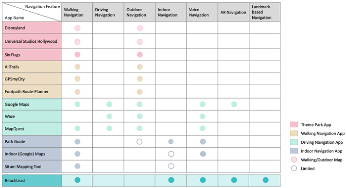
The case study aims to make a deeper understanding and answer the follo- wing research questions: What are the current navigation solutions, and what can we learn from them? What problems do they solve or/and haven’t solved yet? What features can we add to current solutions to add value and address existing pain points? A study of apps with similar functionalities (navigation, maps) was conducted, which could be divided into four categories, including Theme Park apps, Walking navigation apps, Driving navigation apps, and Indoor navigation apps. In each category, three apps were selected based on popularity. The main function, target audience, features, and interface design were analyzed, and a comparison analysis was drawn between the features of these apps (Figure 1).
All the learnings from the survey, interviews, and case study were imple- mented in the final design solution to create an indoor navigation app that fits users’ needs and helps them have a better experience.
DEVELOPMENT This research found that landmark-based navigation integrated with AR navigation is the best solution to improve the campus navigation experie- nce, particularly for people with navigation difficulties. As a result, an iOS mobile application, BeachLead, was developed as a minimum viable product (MVP) for the Department of Design at CSULB (California State University, Long Beach).
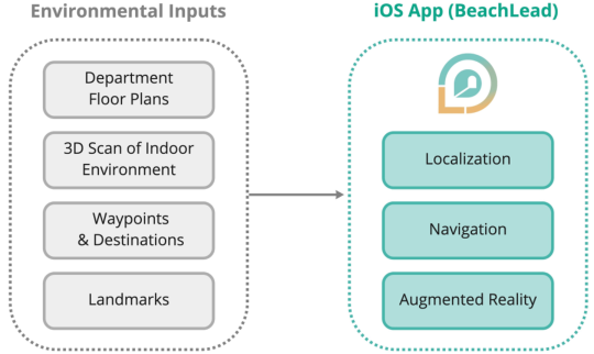
The logic behavior of the BeachLead solution is represented in Figure 2. In order to implement in any indoor environment, BeachLead needs floor plans, waypoints, destinations, landmarks, and 3D scanning of the environ- ment that could be done by using a smartphone. Also, this platform uses computer vision to recognize user surroundings for accurate localization within the environment. Therefore, the solution doesn’t require any addi- tional cost or hardware such as beacon, Matterport camera, etc. Hence it
Immersive AR Landmark-Based Campus Wayfinding Solution 71
Figure 1: Comparison analysis between navigation features in different navigation apps.Figure 2: Logic description of the BeachLead iOS app.
is a cost-effective, scalable, easy to implement, and appropriate solution to extending in different campuses.
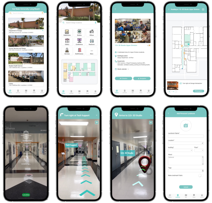
Students can use the mobile application while on campus and in buil- dings to navigate and access different kinds of information about their surroundings. Also, to improve accessibility, various features are supported, such as voice search, voice commands in navigation, and text supplemented with icons. BeachLead is divided into the following main sections (Figure 3). The Explore section is the first page users will experience after they sign in, and this is where they can choose their desired building or location. Users can also choose their desired category to access the complete list of related locations. Color-coded floor plans help users better understand a building at a glance. For each location, specific information is provided, such as descriptions, equipment, and daily schedules.
72 Golestanha and Satterfield
Figure 3: An overview of some of the main pages of the BeachLead app.
The app provides two modes for users to find their destination: Dire- ction mode and AR Navigation mode, both of which use visual recognition to localize the user within the environment. In the Direction mode, users can see landmarks along the shortest path from current location to desti- nation. Landmark-by-landmark direction reassures the users that they are on the right path. Users can also personalize their wayfinding experience by adding their own unique landmarks along the way. The AR navigation mode provides feedback on true/false direction and uses landmarks as navi- gation cues rather than turn-by-turn instructions. For example, “turn right after a vending machine”instead of “turn right after 200 feet.” This decreases users’ feeling of wayfinding confusion and increases their confidence during navigation, especially for people with navigation difficulties.
In the Landmark section, users can add their own landmarks, share them with others, and save their friends’ landmarks. All landmarks that are saved by a user will be shown in their path. Users can also discover landmarks that are shared by others. This creates a community around landmarks as well as increases environmental awareness. The Map section provides a list of all the Points of Interest of the campus. For instance, users can search and find
Immersive AR Landmark-Based Campus Wayfinding Solution 73
nearby locations if they are in outdoor spaces and need a service (inside the building) such as a drinking fountain, restroom, vending machine, etc.
After development, a usability testing of the BeachLead prototype was conducted in both remote and field-based evaluation to measure test users’ performance and understand their problems and preferences during the given tasks. Thus, multiple task scenarios were designed to measure behavioral metrics such as time on tasks, task success rate, abandonment rate, and con- fusion rate. Examples of such tasks are navigating to the specific destination, finding the map orientation, adding a personal landmark, adding a landmark along the way, finding information about a particular class/studio, saving a destination as a favorite, finding the nearest service (printer, vending mach- ine, etc.), and exploring shared landmarks. Also, multiple questions were designed to identify test persons’ opinions, pain points, expectations, and areas for improvement.
Six test users were selected to participate in the usability study. In order to increase the diversity, two of them were completely unfamiliar with the test area (Department of Design), and two had navigation difficulties. In general, the test users found using the AR mode, more helpful and interactive and less confusing in navigating the test area, especially those who struggled with navigation and those who were new to the area. Users mentioned that the use of landmarks helps them to pay more attention to details along the way, and the prototype has a clear and easy-to-understand interface. It was observed that half of the test users would like the app to initiate a prompt (such as pause navigation, new destination, and back to the path) when they’re going in the wrong direction or changing their route, so this issue was addressed during the iteration process. Therefore, the prototype suggests a prompt in addition to feedback on true/false direction. Another observation was that it took a while for BeachLead to localize the test users within the environment in some building spots. One explanation for this could be that the current version of BeachLead uses visual recognition for localization, and some areas don’t have enough visual feature points. So, to improve indoor positioning, one solution could be to place beacons at regular intervals in the building in future developments; however, it leads to additional cost and hardware, and it makes the implementation harder.
CONCLUSION
Campuses can be challenging to navigate since they have vast outdoor envi- ronments combined with a variety of buildings and interior destinations. Thus, the BeachLead app was designed and developed as an immersive AR landmark-based indoor wayfinding solution that works for everyone, including persons who do not use typical navigation strategies or have typi- cal map reading skills. BeachLead uses an innovative combination of AR and motivational strategies to engage students, staff, and visitors to a ple- asurable, accessible, and convenient campus wayfinding experience. This platform increases environmental awareness and empowers students and neurodiverse individuals with navigation difficulties by increasing their con- fidence and independence and decreasing the stress and frustration caused
74 Golestanha and Satterfield
by the excessive cognitive load, which leads to safer and more memorable navigation.
ACKNOWLEDGMENT
The authors would like to acknowledge and offer their deepest gratitude to Dr. Laura Huisinga and Tim Enslow for their invaluable advice, immense knowledge, and plentiful experience they provided to us.
REFERENCES
Beier, D., Billert, R., Bruderlin, B., Stichling, D. and Kleinjohann, B., 2003, October.
Marker-less vision-based tracking for mobile augmented reality. In The Second IEEE and ACM International Symposium on Mixed and Augmented Reality, 2003. Proceedings. (pp. 258-259). IEEE. Chang, Y.J., Peng, S.M., Wang, T.Y., Chen, S.F., Chen, Y.R. and Chen, H.C., 2010.
Autonomous indoor wayfinding for individuals with cognitive impairments. Jour- nal of neuroengineering and rehabilitation, 7(1), pp. 1–13. Creswell, J.W., Plano Clark, V.L., Gutmann, M.L. and Hanson, W.E., 2003. Advanced mixed methods research designs. Handbook of mixed methods in social and behavioral research, 209(240), pp. 209–240. Huisinga, L.A., 2017. Augmented reality reading support in higher education:
Exploring effects on perceived motivation and confidence in comprehension for struggling readers in higher education (PhD dissertation, Iowa State University). Kunhoth, J., Karkar, A., Al-Maadeed, S. and Al-Ali, A., 2020. Indoor positioning and wayfinding systems: a survey. Human-centric Computing and Information Sciences, 10(1), pp. 1–41. Millonig, A. and Schechtner, K., 2007. Developing landmark-based pedestrian-
navigation systems. IEEE Transactions on intelligent transportation systems, 8(1), pp. 43–49. Paucher, R. and Turk, M., 2010, June. Location-based augmented reality on mobile phones. In 2010 IEEE Computer Society Conference on Computer Vision and Pattern Recognition-Workshops (pp. 9–16). IEEE. Richter, K.F. and Winter, S., 2014. Landmarks. Springer Cham Heidelberg New York
Dordrecht London. doi, 10, pp. 978–3. Sansom, A., 2021. Designing wayfinding systems for (neuro)diversity. European Healthcare Design. Sorrows, M.E. and Hirtle, S.C., 1999, August. The nature of landmarks for
real and electronic spaces. In International conference on spatial information theory (pp. 37–50). Springer, Berlin, Heidelberg. Stake, R.E., 2010. Qualitative research: Studying how things work.
LISTED IN THE AHFE DIGITAL BOOKSTORE CATALOGUE
Explore the complete digital volume
The Human Side of Service Engineering
Read this individual research paper free through the original publisher, or explore the full digital proceedings book.
ISBN 978-1-958651-38-4
Explore this ISBN in the AHFE Bookstore ↗Listed in the July 2026 bookstore catalogue; search by ISBN to confirm current availability · Digital book purchase optional