Dennisse Alvarez Macias, Jesús Rafael Hechavarría Hernández, Maria Pin (2022). Strategic urban planning of the banks of the Daule river: Case study in Guayas, Ecuador. In: Human Factors in Architecture, Sustainable Urban Planning and Infrastructure. AHFE Open Access, vol. 58, pp. 232–239. https://doi.org/10.54941/ahfe1002356
The strategic location of the neighborhood “Entrada a Daule” on the banks of the Daule River has led to a disorderly increase in informal settlements over the past decades as result of its proximity to the city of Guayaquil. This study proposes an urban planning that is oriented towards sustainable, organized, and planned development contemplating conditions for environmental development, economic and social growth that are conceived in the assessed region. Therefore, based on the identified variables, it is sought to meet the following objectives: inclusive and equitable resilient urban planning; strengthen local govern through a real citizen participation by carrying out the “Right to the City”; and characterize the existing natural element of the territory as a limiting factor in the creation of land use regulations. In summary, the urban intervention plan aims to recover the dynamics and landscape environmental characterization of the region to achieve a sustainable and comprehensive future in terms of city projection and construction policies.
This research investigates the relationship and interdependence of the effects caused by the urban phenomenon (Sánchez et al. 2021). This phenomenon is characterized by the complexity that urban and functions forms have acqui- red as a result of the accelerated growth of the city of Daule (Castro et al. 2020). Likewise, this phenomenon is influenced by its dynamics within of the sustainable development context; When urban phenomenon’s consequences materialize, urban imbalance is produced which is associated with the incre- ase in the urban population and the deterioration of environmental quality. For this reason, sustainable urban development has been a priority issue for research and commitment. Indeed, the main objective is to con-vert polluted cities into areas that adapt at both their occupants and surrounding nature (Hernández, 2009).
Currently, studies have been carried out under the context of sustainable development defined as “a solution to environmental deterioration and the
Strategic Urban Planning of the Banks of the Daule River 233
loss of quality of life in large metropolises”. These studies consider urbaniza- tion processes as one of the most aggressive man-made pollution impacts for the environment (Alberto, 2009). As a result, the relationship between vari- ous terms such as the environment, economy, society has been determined. It is highlighted that, “if an urban development proposal does not consider at least these three elements, it can-not be considered as sustainable” (Juárez et al. 2009). Similarly, it is recognized that the “concept of sustainability” is linked directly to improving the life quality for citizens”. To achieve this sta- tement is required of an urban planning reform that grant special attention to the effects generated by non-sustainable environments (Alejandre, 2000). Addition-ally, it is necessary to articulate the established regulations of land use and urban practice to achieve right decisions to the existing physical, environmental, and socioeconomic aspects (Alava and Hechavarría, 2020), as well as to analyze the construction of smart cities as strategies of urban management (Alvarado, 2018).
To deal with this issue Ecuador has regulations that promote development and territorial planning. The application hierarchy of these regulations is spe- cified in articles 424 and 425 of the “la Constitución de la República del Ecuador”(CRE, 2008) The Organic Code of Territorial Organization (COO- TAD in Spanish) (COOTAD, 2011) is the organic law that classifies privileges granted to each of the levels of government. According to this hierarchical order, the Daule canton is governed by the planning tool: Territorial Plan- ning and Development Plan, a document that states the regulation of urban growth does not only include the urban area but also the rural one (PDyOT Daule, 2015); however, when verifying compliance with these regulations in real physical space, problems such as weak control and regulation of deve- lopable land by the city government (GAD Municipal) are evidenced, which proves un-planned urban development.
MATERIALS AND METHODS
Delimitation of the Study Area Daule is located at the south latitude 1 ° 52’00" and west latitude 79 ° 59’00", in the south-central littoral region. It represents one of the oldest cantons and the fourth largest and most populated cities of the Guayas province. It has a territorial extension of 534.86 km2 and a population density of 224.96 inha- bitants per km (COOTAD, 2011). The territory of the Daule canton belongs to the sub-basin of the Daule River, which in turn is the largest of the sub- basins of the Guayas Basin, covering a 5% estimate of the national territorial extension, and 36% of the entire Basin of the Guayas River (GADM Daule, 2022). Daule has been characterized as one of the cantons with the highest agricultural production in the coast, being recognized as the rice capital of Ecuador (Alava et al. 2020).
Case-Study Currently, the Daule canton has generated an accelerated urban gro- wth in recent years thanks to its sharp agricultural production and
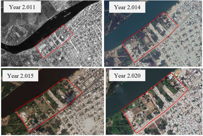
Figure 1: Satellite image of the study region: neighborhood “Entrada a Daule” years 2011–2014 - 2015–2020. (Obtained from Google Earth, 2022).
commercialization activity. This evidences a lack of urban planning crite- ria and an inability to disrupt the disorderly growth of the canton (Castro et al. 2020), specifically in the main town of the municipality where the study region is located: neighborhood Entrada a Daule (see Figure 1). As illu- strated in Figure 1, this region shows an urban layout with irregular blocks evidencing problems such as: informal urbanism, loss of urban image, non- regulated of land use. It is also identified congestion in the infrastructure which is manifested by the same uniform and monotonous pattern for the construction of buildings, visual pollution, environmental pollution, and eco- logical degradation caused by the expropriation of protected areas (generally to provide areas con-strained to human habitation).
According to INEC projections (INEC, 2016), the population of the Daule canton will reach 219,644 inhabitants by 2020. From this estimate, 172,273 corresponds to the inhabitants of the main town of the municipality of Daule (PDyOT Daule, 2015). The neighbor-hood “Entrada a Daule” has an appro- ximate population of 515 inhabitants ac-cording to the information collected on site. This population can be distributed in 19 blocks with 103 lots consi- dering a family structure of 4 to 5 members with 3 adults ranging ages from 18 to 50 years. Consequently, a total of 309 people can be taken as the study population. The obtained sample size is 70 surveys, assuming a confidence level of 90% (1.65) and a sampling error of 10% (0.01).
Description of the Method and Design The research framework used for this study is structured in three stages: exploratory methodology, analytical methodology, and descriptive metho- dology. In the first stage, an exploratory methodology was proposed to
Strategic Urban Planning of the Banks of the Daule River 235
approach to the main issue: “Increase of unplanned urban growth in the urban southwest of the city of Daule”. Subsequently, the hypotheses were raised. The approach of concepts in territorial ordering, planning, and sustai- nable urban development were adopted. These criteria allow to answer the research questions raised about unplanned urban growth in the southwest of the city of Daule.
In the second stage, an analytical methodology was proposed, which is based on the direct experience for the study region. This resulted in the analy- sis of the urban phenomenon (i.e., core of the research). It was explored how society develops focusing in the urban, social, economic, and environmental aspects.
In the third stage, a descriptive methodology was proposed by observing and analyzing the region to be intervened. For this, the study region was segmented, by delimiting the area to be intervened (i.e., the neighborhood “Entrada a Daule”). Then, this area was divided into blocks, the blocks were numbered ranging from No. 1 to No. 19 (blocks/square). After this, the blocks were classified depending on their composition and elements that defi- ned them such as infrastructure, construction typology, current state, among others. This part depends on the sampling obtained and the collection of information gathered in each of the blocks of the study region “neighborhood Entrada a Daule”.
Information Gathered With the information obtained from the diverse applied methodologies, the following characteristics of the region to be intervened in “neighborhood Entrada a Daule” are established.
It is located in an area of immediate development on Av. Vicente Piedrahita, an entrance road with a main axis, which has been regenerated recently and allows direct communication between the main town of the Municipality of Daule and the road network E 48 - Via Colectora Guayaquil-El Empalme.
In the study area, a series of polluting and aggressive activities for the environment occur, such as fuel distribution, vulcanizers, sale of construction materials, among others. This issue is extremely important because of the proximity to the water resource, the Daule river. Similarly, the fragility of area must be maintained and preserved, which constitutes the action guidelines for this research.
The urban landscape of the study area has changed in recent years. This is mainly observed in the excessive division of the land, layout of road network, and irregular constructions, which has resulted in an impact on the physical environment and loss of the ecosystem benefits produced by the Dale River. The internal road layout of the neighborhood “Entrada a Daule” currently has an irregular configuration, highlighting the lack of primary planning for the region. It is evident that there is no organization in the use and consolida- tion of this neighborhood, which has been developed over time by informal settlements.
According to the mapping carried out over the inhabited lots/property, it was determined that most of them are located next to the main road
Av. Vicente Piedrahita. This part is mostly governed by commercial activi- ties. On the other hand, scattered housing lots represents just small fraction of the commercial activities, this part corresponds to residential use, deno- ting a visual impact of social segregation. Regarding the inhabited lots, it is evident that they do not comply with the current construction regulations established for the area, generating a discontinuity of the urban image.
Based on the information obtained from the analysis of land use, it can be said that urban consolidation occurs only in the area next to the main road, Av. Vicente Piedrahita. Whereas, in the zones or areas adjacent to the banks of the Daule River there are unconsolidated urban settlements in a minimum percentage. Thus, if the urbanization process is not controlled it would contribute to the increase of more informal settlements in risk areas (e.g., riverbanks).
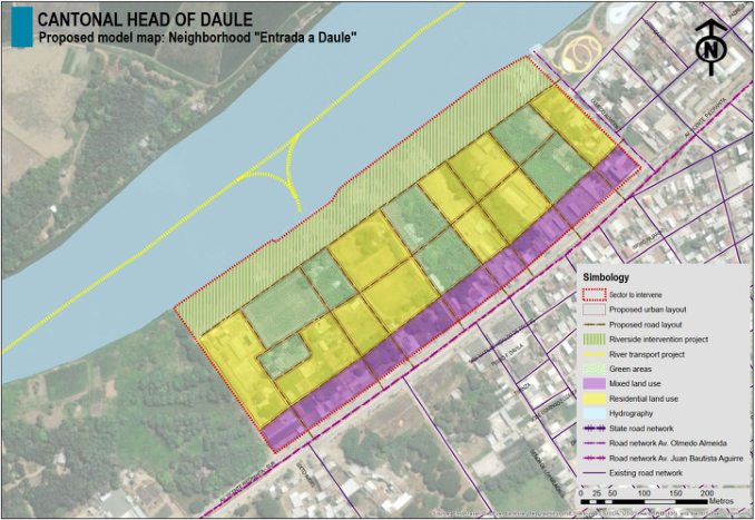
INTERVENTION STRATEGIES The information obtained on site revealed the urban reality of the region to be intervened. This supports the implementation of intervention strategies (see Figure 2) in order to achieve sustainable urban planning on the banks of the Daule River that contain plans and urban regeneration projects. These plans and projects are dictated by the framework of an integral conception of the development of the city, reversing the current trend of the region to convert it and/or promote it in a strategic region of access to the main town of the Municipality of Daule. Therefore, proposals that integrate environmental and landscape values of the natural resource that the Daule River possesses are vital. Among the points to be considered, the following are detailed: pro- posal for a land use plan according to the reality of the site that can determine areas at risk and mitigation barriers; sustainable river transport; design of the Daule River edge as a sustainable public space.
RESULTS
The implementation of intervention strategies in the search for a sustaina- ble urban planning model on the banks of the Daule River, neighborhood “Entrada a Daule” will generate an ideal urban planning that contributes to the improvement of the current territorial planning regulations of the city of Daule. The results are focused on reducing unplanned urban growth in the urban southwest of the city, taking advantage of the different social, econo- mic, cultural, and natural particularities and potentialities. It is highlighted some strengths and opportunities such as the water resource to be develo- ped parallel to the Daule River. This alternative has the potential to become one of the areas with high landscape and environmental value in the Daule canton. Additionally, the current existence of undivided macro vacant lots suggests and encourages a continuity of the urbanization process, which can be developed under the guidelines of a sustainable city. In this way, a heal- thy environment is allowed, which favors the protection of water resources and existing natural ecosystems; characteristics that if properly planned and regularized could be ideal for the sustainable use of the neighborhood.
Strategic Urban Planning of the Banks of the Daule River 237
Figure 2: Proposed model map of the study area: neighborhood “Entrada a Daule”.
The plan of land use, based on the reality of the site that allows determi- ning areas at risk and mitigation barrier, mainly seeks to control and plan urban expansion. However, it is also aimed to regulate urban development, defining the uses compatible with the physical factors that delimit and cha- racterize the region, considering the proximity to the river and its risk of flooding. Among the criteria to consider are controlling the management of domestic wastewater; the use and occupation of the land on the banks and protection strips of the Daule River; recovery of green areas with native plant species; cooperation and strengthening of bodies competent that allow definition, delimitation, and protection fragile natural spaces.
The implementation of sustainable river transport explores the future sce- nario within the general framework of the current urban situation, taking advantage of the strengths and opportunities that the region has in a sustai- nable context. For example, the available resources such as: the Daule River, which results in initiatives such as the implementation of a non-polluting connectivity system that allows revitalizing the fluvial network and the cha- racteristic customs of the canton; the use of canoes traveling along the Daule River that allow communication not only of the study region but from sur- rounding areas such as the parish head of Los Lojas, La Estacada, Laurel, Limonal, Juan Bautista Aguirre and the Las Maravillas campus The intervention on the edge of the Daule River seeks to implement an area of public space that generates social, cultural, and territorial interest. This space can be characterized by the natural origin, landscape that allows it to integrate the existing potentialities within the region, and by implementing this public space. Thus, it will generate improvements in the living conditions of the inhabitants, promoting sustainable development that does not degrade
the environment, and allows relationship between the city and nature like par- ticipation of local citizens and visitors. The implementation of this proposal will promote the use of public space where cultural and recreational quality stands out. As a results, the rehabilitation will create a feasible model from the economic, social, and environmental aspects.
CONCLUSION
Based on the findings of this research, it was possible to understand the relevance of deeply analyze the region to be intervened and to establish the particularities that delimit its structure. Among them, the components that stand out are uncontrolled evolution of urban development and excessive- successive changes of the territory. Therefore, optimizing the current land use regulations of the Daule canton under an urban approach can provide a solution to the effects caused by environmental pollution. This solution can be reflected as an enhanced urban planning aimed at reducing pollution and waste levels. This can be achieved by improving the efficiency in the consum- ption of natural resources. As a result, the habitability of the region and life quality of inhabitants can be im-proved.
In summary, the importance of sustainable urban development and its implementation in programs, plans, and projects were prioritized to renew planning concepts and construction methodologies that allow the develo- pment process of the city (Daule) from a sustainable perspective aimed at ach- ieving equal profit in diverse aspects: economic, social, and environmental.
REFERENCES
Álava Portugal C., Hechavarría Hernández J. (2020). Proposal for a Green Area Master Plan. Case of Study: Nueva Aurora Cooperative, Daule, Ecuador. En: Charytonowicz J. (eds) Advances in Human Factors in Architecture, Sustainable Urban Planning and Infrastructure. AHFE 2020. Advances in Intelligent Systems and Computing, vol 1214. Springer, Cham. https://doi.org/10.1007/978-3-030- 51566-9_27 Álava Portugal C., Hechavarría Hernández J., and Fois Lugo M.: Systemic Appro-
ach to the Territorial Planning of the Urban Parish La Aurora, Daule, Ecuador. In: Ahram T., Karwowski W., Vergnano A., Leali F., Taiar R. (eds) Intelligent Human Systems Integration 2020. IHSI 2020. Advances in Intelligent Systems and Computing, vol 1131. Springer, Cham. (2020) Print ISBN: 978-3-030-39511-7. Online ISBN: 978-3-030-39512-4. First Online: 22 January 2020. https://doi.or g/10.1007/978-3-030-39512-4_183. Alberto, J. (2009). Geografía y crecimiento urbano. Paisajes y problemas ambientales, Geográfica Digit. https://doi.org/10.30972/geo.6112840. Alejandre Martín, C. (2000). Urbanismo, energía y medio ambiente, Obs. Medioam-
bient.,. https://doi.org/10.5209/rev_OBMD.2000.n3.23115. Alvarado López. R. (2018). Ciudad inteligente y sostenible: hacia un modelo de innovación inclusiva,” PAAKAT Rev. Tecnol. y Soc., https://doi.org/10.18381/pk.a7n 13.299 Asamblea Constituyente de Montecristi, “Constitución de la República del Ecuador,”
Strategic Urban Planning of the Banks of the Daule River 239
Código Orgánico de Organización Territorial, COOTAD. (2011). Website: https: //www.cpccs.gob.ec/wp-content/uploads/2020/01/cootad.pdf Castro D., Vega G., Hechavarría Hernández J.R. (2020). Proposal for Integration of
Urban Planning with the Environment in Daule - Ecuador. En: Karwowski W., Goonetilleke R., Xiong S., Goossens R., Murata A. (eds) Advances in Physical, Social & Occupational Ergonomics. AHFE 2020. Advances in Intelligent Systems and Computing, vol 1215. Springer, Cham. https://doi.org/10.1007/978-3-030- 51549-2_62 Hernández Aja, A. (2009). Calidad de Vida y Medio Ambiente Urbano: Indicadores Locales de Sostenibilidad y Calidad de Vida Urbana, Rev. INVI. https://doi.org/ 10.4067/s0718-83582009000100003 Instituto Nacional de Estadísticas y Censos, “Ecuador en cifras,” Inec, (2016).
Website: https://www.ecuadorencifras.gob.ec Juárez Sánchez, J., Ramírez Valverde, B., and Galindo Vega, M. (2009). Turismo rural y desarrollo territorial en espacios indígenas de México, Investig. Geográficas. https://doi.org/10.14198/ingeo2009.48.07. Municipalidad de Daule., Datos generales. Website: https://www.daule.gob.ec/web/g
uest/datos-generales Plan de Desarrollo y Plan de Ordenamiento Territorial del cantón Daule 2015-2025.
Website: http://app.sni.gob.ec/sni-link/sni/PORTAL_SNI/data_sigad_plus/sigad plusdiagnostico/0960000490001_PDyOT%20DAULE%20-%202015-2025% 20FASE%20DIAGN%C3%93STICO_13-03-2015_11-30-32.pdf Sánchez Padilla, M.L., Hechavarría Hernández J.R., and Portilla Castell Y. (2021).
Systemic Analysis of the Territorial and Urban Planning of Guayaquil. En: Ahram T.Z., Karwowski W., Kalra J. (eds) Advances in Artificial Intelligence, Software and Systems Engineering. AHFE 2021. Lecture Notes in Networks and Systems, vol 271. Springer, Cham. Print ISBN: 978-3-030-80623-1, Online ISBN: 978-3- 030-80624-8. https://doi.org/10.1007/978-3-030-80624-8_51
LISTED IN THE AHFE DIGITAL BOOKSTORE CATALOGUE
Explore the complete digital volume
Human Factors in Architecture, Sustainable Urban Planning and Infrastructure
Read this individual research paper free through the original publisher, or explore the full digital proceedings book.
ISBN 978-1-958651-34-6
Explore this ISBN in the AHFE Bookstore ↗Listed in the July 2026 bookstore catalogue; search by ISBN to confirm current availability · Digital book purchase optional