Ming-der May (2026). AI Collaborative and Active Learning for GIS Course with School Bus Routing Project. In: Human Interaction and Emerging Technologies (IHIET 2026). AHFE Open Access, vol. 236, pp. 201–210. https://doi.org/10.54941/ahfe1008096
The rapid proliferation of generative artificial intelligence (AI) has necessitated a paradigm shift in higher education, particularly within Geographic Information Systems (GIS) pedagogy. Traditional models often fail to bridge the gap between abstract spatial theory and the technical frictions of real-world implementation. This study evaluates a Project-Based Learning (PBL) framework augmented by AI—acting as a "co-pilot"—to enhance student engagement and technical mastery. Centered on the Xinxing High School School Bus Routing Problem (SBRP), the project involved the high-precision scheduling of 1,124 students across 124 distinct demand nodes. By leveraging AI-augmented optimization, the research demonstrates significant operational dividends: fleet consolidation from 41 to 32 vehicles, a 19.3% reduction in carbon emissions, and the achievement of 100% punctuality. Furthermore, this collaborative approach addresses critical academic integrity concerns by transitioning from generic assessments to "Authentic Assessment," requiring localized data-driven reasoning and human-centric trade-offs.
INTRODUCTION: LITERATURE REVIEW AND PEDAGOGICAL PAIN POINTS In contemporary higher education, bridging the strategic gap between GIS theory and its practical execution is an enduring challenge. While the conceptual power of spatial analysis is vast, students frequently encounter technical “bottlenecks” that impede higher-order learning. These frictions— ranging from arduous syntax debugging in Python to the nuances of coordinate transformations—often stall project momentum before significant spatial insights are generated. Specifically, the transition from WGS84 (global positioning) to TWD97 (local precision) remains a common point of failure for novice analysts.
To mitigate these barriers, this study synthesizes “Cognitive Scaffolding” theory which posits that temporary technical supports enable students to operate within their “Zone of Proximal Development” (Vygotsky, 1978). In this framework, AI serves as a collaborative peer, functioning as a “thinking partner” to handle repetitive syntax while students focus on systemic logic. Critically, as traditional assessment formats like take-home essays become Received June 30, 2026; Revised July 10, 2026; Accepted July 30, 2026; Available online August 25, 2026
202 May increasingly vulnerable to AI-generated plagiarism, geographers must pivot toward “Authentic Assessment” (Yang, 2026). This necessitates tasks that replicate real-world complexities and require personal reflection on unique, localized datasets. The purpose of this research is to validate an innovative PBL framework that utilizes AI to solve localized School Bus Routing Problem (SBRP) challenges, transforming students from passive learners into active system engineers.
Foundational Concepts: The Vehicle Routing Problem (VRP) The Vehicle Routing Problem (VRP) is a quintessential optimization challenge deeply rooted in logistics, transportation, and supply chain management. In its most fundamental sense, the VRP addresses a complex logistical dilemma: “How can a fleet of vehicles be assigned to depart from a central depot, deliver goods to geographically dispersed customers, and determine the most cost-effective, time-efficient, or shortest routes while strictly adhering to a set of operational constraints?”
To accurately model real-world commercial and logistical operations, the problem typically comprises several core elements: Nodes (Geographic Points): This includes the “Depot” (the starting point for vehicles and the location they must return to upon task completion) and “Customers” (the precise geographic coordinates requiring service).
Constraints: These are the critical parameters that align the theoretical VRP model with real-world limitations. Common constraints include: Capacity Constraints: Every vehicle possesses a strict maximum threshold for weight or volume. Route planning must inherently prevent any vehicle from overloading.
Time Windows: Customers often require deliveries within specific, rigid timeframes (e.g., strictly between 09:00 AM and 11:00 AM). The routing algorithm must ensure vehicles arrive within these designated windows.
Working Hours and Distance Constraints: Human factors and mechanical limits necessitate caps on maximum legal driver working hours and the maximum travel distance a vehicle can cover in a single shift.
Optimization Objective: This is the ultimate mathematical goal pursued by the computational algorithm. Typical objectives include “minimizing total travel distance,” “minimizing total operational costs (fuel consumption plus personnel expenses),” or “utilizing the absolute minimum number of vehicles to fulfil all orders.”
The School Bus Routing Problem (SBRP) The School Bus Routing Problem (SBRP) is a highly specialized application and extended variant within the broader VRP family. While traditional VRP focuses primarily on optimizing routes to minimize operational costs— such as fleet size and total travel distance—the SBRP adapts this rigorous mathematical framework to the specific, nuanced real-world scenario of school transportation.
Technically, the SBRP is often formulated as a Capacitated Vehicle Routing Problem with Time Windows (CVRPTW). It inherits the VRP’s core constraints, including strict vehicle capacity limits to prevent dangerous
AI Collaborative and Active Learning for GIS Course With School Bus Routing Project 203 overloading and rigid time windows to ensure students arrive at school promptly before the morning bell. However, the SBRP significantly builds upon the pure mathematical optimization of the VRP by intricately integrating human-centric service quality factors. It inherently prioritizes student safety, minimizes exhaustive ride times, and consciously avoids overly early morning departures to protect students’ sleep and overall well-being. In summary, the VRP provides the foundational computational algorithms and routing logic, whereas the SBRP meticulously tailors these analytical tools to meet the unique operational constraints and human-centric needs of daily school commutes.
Practical Application: Problem Statement The SBRP represents a critical, daily operational challenge for educational institutions. For Xinxing High School in Taoyuan City, the traditional manual approach to dispatching school buses has historically led to significant systemic inefficiencies. The project involved the high-precision scheduling of 1,124 students across 124 distinct demand nodes. Relying heavily on human intuition and straight-line estimations frequently results in severe geographic overlapping, excessive daily travel mileage, and fundamentally mismatched vehicle capacities across different routes.
Consequently, these inefficiencies drastically inflate fleet operational costs while negatively impacting the quality of service provided to the student body. Concurrently, the dispatched buses frequently face the risk of severe capacity overloading or arriving late due to unpredictable urban traffic congestion and sub-optimal route sequencing.
METHODOLOGY: AI-AUGMENTED PBL FRAMEWORK Managing the intersection of spatial data, mathematical algorithms, and AI logic requires a rigorous methodological framework to properly handle the Capacitated Vehicle Routing Problem with Time Windows (CVRPTW). The Xinxing High School SBRP is strictly defined by several non-negotiable “Hard Constraints”:
Dual-Directional Time Windows: To safeguard student sleep preservation, the absolute earliest start time is strictly set at ≥ 06:30, paired with a mandatory campus arrival deadline of 07:25.
Heterogeneous Fleet Capacities: The model utilizes a dynamic, mixed fleet consisting of Large buses (44 seats), Medium buses (20 seats), and Small buses/vans (8 seats).
Safety-Centric Road Speed Parameters: Realistic travel times are modeled at 20 km/h for urban segments and 35 km/h for highways. Additionally, a highly conservative 15 km/h safety standard is rigidly applied to zones with extreme urban congestion.
To navigate these complexities, the project employs a Trinity Collaboration Model, which functions as a robust form of cognitive scaffolding: Traditional GIS: Facilitates the essential tasks of spatial data cleaning, accurate coordinate transformation, and the meticulous construction of high-precision road network topologies.
204 May VRP Solvers: Implements heuristic algorithms (such as Genetic Algorithms and Simulated Annealing) to calculate the mathematical optimum for route sequences and payload balancing.
AI Collaboration: Provides prompt-based refinement to continuously identify algorithm “blind spots,” fundamentally ensuring that the generated mathematical solutions are highly operationally feasible and deeply human-centric.
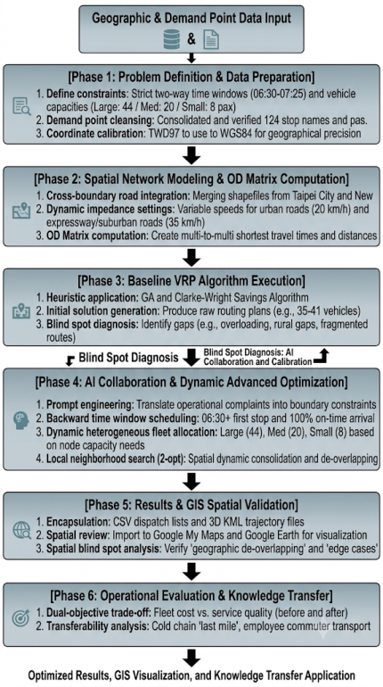
Figure 1 outlines a comprehensive six-phase methodological framework for optimizing school bus vehicle routing, structured around dynamic data integration and human-AI collaboration. It begins with data preparation and problem definition (Phase 1), establishing strict spatial coordinates and operational constraints, including two-way time windows. Phase 2 models the cross-boundary spatial network and computes a foundational Origin- Destination (OD) matrix. Phase 3 executes baseline heuristic algorithms for an initial routing solution, which undergoes a systematic blind-spot diagnosis to identify practical operational gaps. This diagnosis feeds iteratively into Phase 4, which leverages dynamic advanced optimization and AI collaboration— incorporating human operational feedback through prompt engineering— for adjustments such as dynamic heterogeneous fleet allocation. Following optimization, Phase 5 executes results validation using GIS visualization and 3D KML trajectory files for spatial analysis, specifically checking for geographic de-overlapping and edge case coverage. Finally, Phase 6 performs a dual-objective trade-off analysis of operational costs versus service quality, exploring the methodology’s broader transferability. This integrated workflow ultimately yields optimized, visualizable results and actionable knowledge transfer applications.
EMPIRICAL APPLICATION I: SPATIAL DATA PROCESSING The project focused intensively on 124 demand nodes dispersed across New Taipei City and Taoyuan City, requiring a highly sophisticated integration of cross-county network datasets. The primary technical hurdle involved synchronizing distinct coordinate systems to ensure computational accuracy.
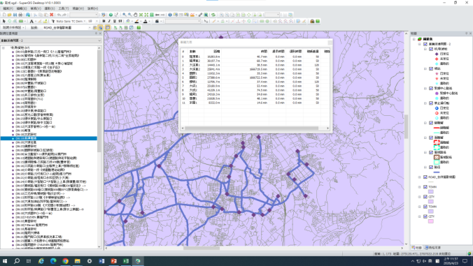
Analytical Procedures of Traditional GIS Software As documented in the foundational phases of the research, students primarily utilized traditional GIS software (e.g., SuperGIS Desktop of Figure 2) to establish the necessary spatial infrastructure. The two generated tables of data are key input data for traditional GIS software and AI (Table 1). The rigorous procedures encompassed:
Coordinate Transformation and Precise Positioning: Accurately converting the Google Maps geographic coordinates (WGS84) of over 100 student pick-up stops into the Two-Degree Transverse Mercator coordinate system (TWD97) applicable in Taiwan. This crucial step ensures all subsequent computations are conducted strictly in meters, thereby systematically eliminating localized positioning errors.
Cross-Boundary Road Network Selection and Merging: Utilizing advanced GIS spatial data processing tools to meticulously select and merge disparate road network shapefiles from Taoyuan City and New Taipei City.
AI Collaborative and Active Learning for GIS Course With School Bus Routing Project 205 A primary focus was placed on repairing and enforcing Topology Continuity at administrative boundaries to prevent algorithm failure.
Network Modelling and OD Matrix Computation: Converting the raw spatial layers into a highly functional Network Dataset. Crucially, during the Origin-Destination (OD) Matrix calculation, the A-Star weighting was deliberately set to 0. This forced a comprehensive search of the network dataset, permanently moving beyond “straight-line fallacies” to account for one-way streets, turn restrictions, and varying speed limits. By assigning differential impedance weights for urban roads (20 km/h) and suburban/ expressways (35 km/h), a multi-to-multi OD Matrix for shortest travel distances and times—based purely on the “actual road network”—was successfully computed.
Baseline VRP Solving: Importing the newly generated OD matrix into VRP software modules to cleanly execute baseline heuristic algorithms, yielding an initial, mathematically sound estimation of fleet size and raw routing plans.
Figure 1: Six-phase methodological framework for optimizing school bus vehicle routing.Table 1: Critical input data for both traditional GIS and AI.
Table available in the original PDF paper.
File Name Content Description Key Fields Purpose google_stops. xlsx Passenger Demand Table Defines demand points and passenger load.
Stop Name, Number of Boarding Passengers, Address
124_points_ OD_matrix.txt
Distance Matrix From, To, Distance (m), Time (min)
Provides the actual driving distance between any two points, which is more accurate than straight-line distance.
Figure 2: VRP solving result of SuperGIS desktop adapted from Lee (2026).
EMPIRICAL APPLICATION II: AI-COLLABORATIVE OPTIMIZATION The integration of Generative AI represents a critical pivot point in the methodology, actively shifting the student’s role from a mere “manual drafter” to a sophisticated “system engineer.” Following the generation of baseline routes, students were tasked with identifying algorithmic “Blind Spots”— instances such as local optima that generated highly inefficient peripheral routes or “too-early” start times (e.g., 05:40) that mathematically worked but completely disregarded student well-being.
The core VRP engine utilized a robust Simulated Annealing algorithm configured with highly specific parameters: 1,000 iterations, an initial temperature of 500, a cooling frequency of 10, and a cooling rate of 0.9. To bridge the gap between these raw mathematical outputs and true operational feasibility, students leveraged structured Prompt Engineering: Backward Scheduling: AI was explicitly prompted to work backward from the strict 07:25 school arrival time. It was instructed to prioritize the 06:30 “hard floor” departure time, effectively rejecting and recalculating any route proposing an earlier boarding time.
AI Collaborative and Active Learning for GIS Course With School Bus Routing Project 207 Dynamic Fleet Downgrading: The AI rigorously analyzed low-occupancy geographic “islands.” Instead of sending empty large buses, it recommended 8-person vans for these isolated peripheral areas. This strategy included maintaining a “Dynamic Rescue Capacity,” where specific small buses were strategically reserved for emergency logistical support.
Smart Transit Parameters: The final AI optimization incorporated a mandatory 1-minute service stop time per station to accurately reflect human boarding delays. It also specifically addressed localized traffic bottlenecks, dynamically routing around known congestion on Zhonghua Road in Zhongli and active construction zones on Yingtao Road in Yingge.
Procedures for AI-Assisted Solving and Visualization Prompt Engineering for Diagnosis and Debugging: Students actively fed the flawed preliminary solutions (highlighting capacity violations and premature departures) generated by the traditional VRP modules back into the AI. By guiding the AI, they successfully identified complex “geographic clusters” and enforced rigid operational constraints.
Dynamic Route Recombination and Fleet Downgrading: Through iterative dialogue, the AI facilitated advanced “spatial de-interlacing (de-overlapping)” and “same-stop passenger diversion.” For highly fragmented peripheral stops, the AI seamlessly assisted in formulating the logical rules necessary to dynamically downgrade assignments from large buses (44 passengers) to medium (20 passengers) or small buses (8 passengers).
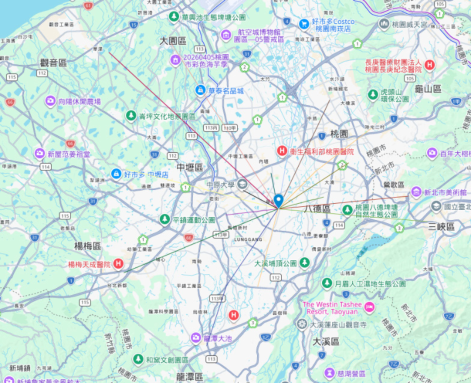
Visualization Coding and Format Encapsulation: The AI played a crucial role in bypassing tedious programming syntax for the students. It swiftly converted complex, tabular final schedules into highly standardized digital formats. This included generating pristine CSV dispatch lists directly importable into Google My Maps, alongside sophisticated KML files containing 3D realistic curved road trajectories ready for high-fidelity rendering in Google Earth.
RESULTS AND GIS VISUALIZATION The empirical application yielded transformative operational results. Through the synthesis of GIS and AI optimization, the school’s fleet was successfully consolidated from an initial 41 manually scheduled vehicles down to a highly efficient 32 vehicles. This optimization translated directly into a 19.3% reduction in overall carbon emissions and the achievement of a 100% on-time arrival rate within the strict 06:30 to 07:25 time window.
Comparative Analysis of Student Outcomes and Strategies A critical component of this PBL framework was analyzing how individual students navigated the problem space. Although the project framework and core datasets were entirely uniform, students exhibited varying depths of professional expertise in algorithm application, parameter fine-tuning, and qualitative analysis.
208 May Algorithmic and Strategic Differences: Students approached the resolution of capacity overloads through distinct strategic lenses. Certain students focused mathematically on modifying the penalty weights of the objective function within the VRP solver. Conversely, other students creatively introduced the Clarke-Wright Savings Algorithm to achieve geometric edge recombination. They expertly utilized a “same-stop passenger diversion” strategy—for instance, simultaneously dispatching a large bus and a medium bus at the heavily populated Daxi Renhe Junior High School stop—to dynamically mitigate localized capacity crises without compromising route flow.
Insights into Extreme Spatial Blind Spots: In terms of advanced spatial analysis, high-performing students demonstrated exceptional problem- solving capabilities. For example, one student applied the sophisticated DBSCAN density clustering method to accurately identify distinct “geographic islands” (such as the highly isolated residence of student ‘1024’) that are routinely overlooked or poorly serviced by traditional dispatching methods. These isolated nodes were purposefully decoupled from main routes and independently allocated to medium buses navigating expressways. This strategic decision prevented massive 44-seat buses from being trapped in narrow alleys or engaging in highly inefficient, time-consuming detours.
Variations in Presentation Mediums and Perspectives: The chosen formats for final deliverables highlighted different professional orientations. The comprehensive written reports submitted in Word format provided highly detailed qualitative narratives, meticulously documenting their iterative AI prompt histories and deeply analysing the complex operational trade-offs involved in dispatching. In stark contrast, PPT presentations pivoted towards a more executive, macro-level perspective. They designed their outputs to resemble a “digital twin command center,” heavily emphasizing visual KPI dashboards, stark pre- and post-optimization comparative matrices, and dynamic 3D realistic trajectory demonstrations aimed at upper management decision-makers.
Figure 3: The Google MyMap’s linear route map from student’s term project (Lin, 2026).
AI Collaborative and Active Learning for GIS Course With School Bus Routing Project 209 DISCUSSION: THE ROLE AND PEDAGOGICAL BENEFITS OF AI IN PROBLEM SOLVING AND STUDENT LEARNING
Crucially, this AI-collaborative framework serves as a robust defense and practical implementation of the Authentic Assessment model. Yang’s (2026) recent survey findings indicate a stark reality in modern academia: 80% of geography students already actively utilize ChatGPT, a rate significantly higher than their peers in medical (48.9%) or pharmacy (22%) disciplines. This stark discrepancy highly suggests that geography’s heavily conceptual and data-driven nature is uniquely suited for deep AI collaboration. Because the SBRP project mandates the cleaning of specific, highly localized data (e.g., addressing temporary construction delays on Yingtao Road) and demands highly personalized spatial reasoning, it inherently renders traditional AI-generated plagiarism obsolete. As 70% of students in the Yang (2026) study expressed a clear preference for PBL formats over traditional written exams, this pedagogical approach successfully ensures strict academic rigor while concurrently fostering the genuine creativity and critical thinking required for real-world logistical problem-solving.
Roles and Benefits in “Problem Solving”: Acting as an “Advanced Logic Consultant” and Dispatch Expert, AI fundamentally disrupts the rigid, single-vehicle-type assignment paradigm of traditional methodologies. When confronted with isolated stops experiencing massive passenger overflow or remote geographic blind spots, the AI seamlessly cross-references the network topology to propose high-level operational decisions, such as “dynamic heterogeneous fleet downgrading” and “cross-regional dynamic consolidation.” As a direct benefit, under the uncompromising prerequisites of zero overloading and zero delays, the fleet size was successfully consolidated from 41 manually scheduled buses to a highly optimized 32 buses. Furthermore, the average vacancy rate across the fleet was drastically compressed, elevating the overall load factor to over 93%, thereby maximizing the true operational efficiency of green transportation.
Roles and Pedagogical Benefits in “Student Learning”: Serving seamlessly as a “Coding Co-pilot” and providing essential “Cognitive Scaffolds,” AI transforms the classroom experience. In traditional GIS education, students frequently lose weeks managing tedious XML/KML syntax encapsulation or struggling with the underlying mathematical formulas for coordinate transformations, rapidly leading to academic exhaustion from technical minutiae. AI assumed the heavy responsibility of syntax debugging, successfully and completely removing these frustrating technical barriers. The primary benefit is the Shifting of the Cognitive Load. The AI does not replace student thinking; rather, it purposefully shifts the students’ “cognitive load” entirely away from tedious syntax debugging and squarely onto “high- level geographic decision-making” and “dual-objective trade-off analysis” (balancing strict operational costs against human service quality). This successfully transforms students from passive operators receiving unilateral instructions into “active spatial problem solvers” fully equipped with the critical thinking capacity to systematically resolve highly complex spatial problems.
CONCLUSION
This comprehensive empirical application to the Xinxing High School SBRP decisively demonstrates that the deliberate synergy between human strategic decision-making and AI computational efficiency can achieve profound, measurable gains in both environmental sustainability and operational excellence. The direct reduction of the active fleet to 32 vehicles, coupled with a certified 19.3% savings in carbon emissions, represents a massive and tangible ESG (Environmental, Social, and Governance) contribution to the campus infrastructure.
Looking forward, this distinct “Data-Driven + AI Collaborative” model offers immense, broad applicability for a multitude of adjacent industries, including complex e-commerce last-mile logistics, dynamic industrial park shuttles, and advanced Demand Responsive Transport Systems (DRTS). As modern GIS education continues to rapidly evolve, academia must firmly continue to leverage AI not as a crutch, but as an advanced scaffolding tool, rigorously training the next generation of spatial analysts to expertly bridge the widening gap between “cold algorithms” and “warm, human-centric” logistical scheduling.
REFERENCES
Adams, P. (2006) ‘Exploring social constructivism: Theories and practicalities’, Education 3-13, 34(3), pp. 243–257. doi: 10.1080/03004270600898893. Lee, M.-Y. (2026), Xinxing High School Bus Routes – School Bus Route Optimization
and GIS Visualization Practice, Term Project Report of Geographic Information Systems Course, LungHwa University of Science and Technology (In Chinese). Lin, T.-C. (2026), Xinxing High School Bus Routes – School Bus Route Optimization and GIS Visualization Practice, Term Project Report of Geographic Information Systems Course, Lung Hwa University of Science and Technology (In Chinese). Vygotsky, L. S. (1978). Mind in Society: Development of Higher Psychological
Processes (M. Cole, V. Jolm-Steiner, S. Scribner, & E. Souberman, Eds.). Harvard University Press. https://doi.org/10.2307/j.ctvjf9vz4 Yang, H. (2026) ‘Advancements in artificial intelligence and the reframing of student assessment in geography education’, Journal of Geography in Higher Education, pp. 1–11. doi: 10.1080/03098265.2026.2628342.
SEARCH THE AHFE DIGITAL BOOKSTORE BY ISBN
Explore the complete digital volume
Human Interaction and Emerging Technologies (IHIET 2026)
Read this individual research paper free through the original publisher, or explore the full digital proceedings book.