Jennifer Palilonis, Charlie Meredith (2025). GoodMaps Indoor Navigation: Leveraging Computer Vision to Foster Indoor Navigation. In: Human Interaction and Emerging Technologies (IHIET-AI 2025): Artificial Intelligence and Future Applications. AHFE Open Access, vol. 161, pp. 94–102. https://doi.org/10.54941/ahfe1005900
People around the world have come to rely on digital maps–accessible with the tap of a smartphone screen–to guide them places, to locate areas with which they are unfamiliar, and to get directions to desired destinations. In a world that is overflowing with technological advancements, we expect to be shown, in real time, how to get from point A to point B. However, navigating indoors using assistive technology can prove more challenging than navigating outdoors, as indoor spaces have not traditionally been mapped the way outdoor spaces have by companies like Google and Apple. Additionally, most indoor mapping and navigation services are not very accurate or accessible to meet the needs of a variety of users, including individuals with disabilities. Founded by American Printing House for the Blind (APH) in 2019, the GoodMaps Indoor Navigation smartphone app is addressing these challenges by leveraging artificial intelligence (AI) and crowd-sourced data to scale its app and map coverage efficiently. GoodMaps uses AI–primarily through computer vision algorithms–to create highly accurate indoor maps and to enable precise navigation for users. The app allows them to navigate complex indoor spaces like airports, university campuses, and more by providing detailed turn-by-turn directions. GoodMaps’ computer vision technology interprets real-time data from a device's camera and sensors, effectively guiding users through the environment even without visual sightlines. This is particularly valuable for people with visual impairments or mobility challenges who need assistance navigating intricate indoor spaces. Currently, AI-driven translation capabilities enable the app to support four languages, with six more planned by early 2025, automating 90% of destination translations for non-English users. Looking ahead, GoodMaps aims to further harness AI to dynamically adapt to changes in indoor environments. AI-powered image recognition will enable automated detection of environmental updates via user device cameras, while crowd-sourced contributions from users will provide real-time feedback similar to Waze. This combination of AI and community-driven updates will streamline map maintenance, improve accessibility, and set a new standard for scalable indoor navigation solutions. GoodMaps is also partnering with Intel to deliver a high-quality indoor wayfinding solution for people who are blind or visually impaired. Safely and effectively navigating indoor spaces results in greater independence and confidence when traveling. Intel continues to investigate volumetric mapping algorithms and advances in artificial intelligence to improve the precision and accuracy of GoodMaps’ commercial indoor wayfinding service. This paper will explain GoodMaps’ user-centered design process, chronicling how user experience research has informed the development of AI-driven computer vision models to address user requirements.
People around the world have come to rely on digital maps–accessible with a tap on a smartphone screen–to guide them places, to locate areas with which they are unfamiliar, and to get directions to desired destinations. In a world that is overflowing with technological advancements, we expect to be shown, in real time, how to get from point A to point B. However, navigating indoors using assistive technology can prove more challenging than navigating outdoors, as indoor spaces have not traditionally been mapped the way outdoor spaces have by companies like Google and Apple. Additionally, most indoor mapping and navigation services are not very accurate or accessible to meet the needs of a variety of users, including individuals with disabilities. Founded by American Printing House for the Blind (APH) in 2019, the GoodMaps Indoor Navigation smartphone app attempts to address these challenges by leveraging artificial intelligence (AI) and crowd-sourced data to scale its app and map coverage efficiently.
GoodMaps uses AI–primarily through computer vision algorithms–to create highly accurate indoor maps and to enable precise navigation for users. The app allows people to navigate through complex indoor spaces like airports, university campuses, and more by providing turn-by-turn directions.
This is particularly valuable for people with visual impairments or mobility challenges who need assistance navigating intricate indoor spaces. Likewise, AI-driven translation capabilities enable the app to support nine languages in 2025, including English, Spanish, French, Dutch, Chinese, Vietnamese, Tagalog, Korean, and Russian, automating 90% of destination translations for non-English users. Additional language translations–including German, Italian, Polish, Turkish, Ukrainian, Portuguese, and Welsh–are planned for future release.
Looking ahead, GoodMaps aims to further harness AI to dynamically adapt to changes in indoor environments. AI-powered image recognition will enable automated detection of environmental updates via user device cameras, while crowd-sourced contributions from users will provide real- time feedback similar to Waze, a mobile app that provides real-time driving directions based on live traffic updates. This combination of AI and community-driven updates will streamline map maintenance, improve accessibility, and set a new standard for scalable indoor navigation solutions. Likewise, added safety and efficiency in navigation is intended to result in greater independence and confidence while traveling. Additionally, GoodMaps is partnering with Intel to deliver a high-quality indoor wayfinding solution for people who are blind or visually impaired. Intel continues to investigate volumetric mapping algorithms and advances in AI to improve the precision and accuracy of GoodMaps’ commercial indoor navigation service.
This paper explains GoodMaps’ user-centered design process, chronicling how user experience research has informed the development of AI-driven computer vision models to address user requirements. Current and future applications of AI in GoodMaps indoor wayfinding are also addressed.
REVIEW OF BACKGROUND Artificial intelligence is used in maps and navigation systems to improve the accuracy and efficiency of routing.AI can analyze data to learn user preferences and behaviors and then suggest the best route to a destination. Navigation systems are computer-based systems that can be embedded in a vehicle or mobile device to deliver a real-time value of its current location (Nasserddine & Amal, 2023). Research has focused on use of microprocessors integrated with navigation systems to produce hyper- accurate location results and environmental sensors (Hasan, et al., 2009). In many contemporary systems, information collected by system sensors is combined with a GPS position to provide users with a more accurate representation of an environment (Zhuang et al., 2023).
Applications of AI in Commonly Used Map Apps Contemporary outdoor map apps integrate AI in a variety of ways.
Waze, a Google-owned app that provides real-time driving directions,uses the AI model Gemini in the app’s Conversational Reporting feature, which allows users to report issues by speaking (Berkovich, 2024). Gemini is a
96 Palilonis and Meredith
family of AI models developed by Google DeepMind that can process multiple types of data, including text, images, video, audio, and code.Gemini is designed to be multimodal, meaning it can understand and combine different types of information (Team et al., 2023). Gemini can extract text from images, convert image text to JSON, generate answers about images, write and edit content, and search a user’s inbox (Liedtke, 2024). This conversational feature allows Waze’s 180 million monthly users to announce hazards in the road and verbally identify problems that affect traveling times (Berkovich, 2024).
Google Maps and Apple Maps use AI to improve the navigation experience, to offer recommendations customized to user preferences, and to increase safety. By Fall 2024, Google Maps had surpassed two billion monthly users worldwide (Daniel, 2024), and users rely on many of the AI-enhanced features. For example, AI analyzes real-time traffic data, road conditions, and user preferences to provide Google Maps users with information about the most time- and fuel-efficient routes, the safest routes, and parking availability at a user’s destination (Lau, 2020; digitaldefynd.com, 2025). Both Google and Apple maps use AI to learn users’ interests and habits to provide personalized recommendations for food, shopping, entertainment, and more. Finally, Google uses AI to offer navigation assistance for individuals with disabilities (Singh, 2024). Apple Maps also uses AI to improve place recognition, making it easier for users to find locations based on vague or incomplete searches (digitaldefynd.com, 2025).
Challenges Sometimes, AI-driven apps provide false or misleading information, also known as “hallucinations” (Guinness, 2024). For example, Google’s AI was caught hallucinating in May 2024, “including advice to put glue on pizza and an assertion that the fourth U.S. president, James Madison, graduated from the University of Wisconsin, located in a city named after him” (Liedtke, 2024, para. 9). Researchers have also identified several other challenges that could affect the implementation of AI in maps, including the fact that data translation processes (e.g., aggregation, data manipulation, computation, and visualization) can result in skewed representation of reality (Hagendorff & Wezel, 2020). Likewise, researchers have identified ethical concerns related to AI-generated maps, including “inaccuracies, misleading information, unanticipated features, and the inability to reproduce results” (Zhang, Kang & Roth, 2023, p. 93.3). As AI matures, however, it is inevitable that these shortcomings will also be mitigated.
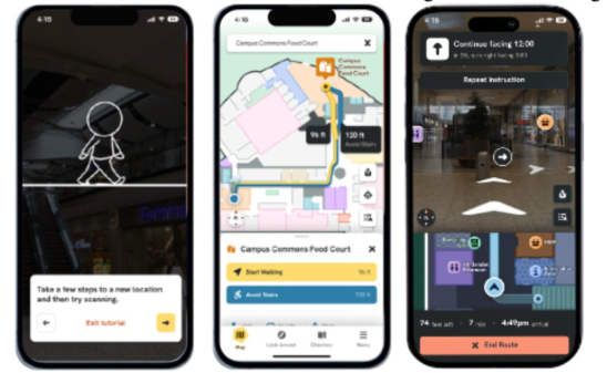
Figure 1: The GoodMaps app offers a visual interface similar to outdoor navigation apps. GoodMaps users can access interactive tutorials that explain basic app functionality (left). They can also choose walking routes or routes that avoid stairs (middle). While in route, users can view an augmented reality view that includes directional arrows superimposed on the screen, as well as a map view that can be expanded and minimized (right).
GOODMAPS INDOOR NAVIGATION Prior publication has defined the GoodMaps app and user experience:
“Originally released in 2020, GoodMaps is a smartphone app for iOS and Android devices that provides turn-by-turn navigation for indoor spaces. The app is designed to help people navigate safely and efficiently with dynamic routing instructions, orientation aids, and landmark recognition. To create an accessible building map, a GoodMaps technician scans a facility with a LiDAR camera that captures 360-degree images, measurements, and video. Second, an accurate, detailed map is created from the scan data. Points of interest–like restrooms, offices, dining, fire extinguishers, exits, etc.–are tagged in GoodMaps Studio, which processes and hosts all map data. Studio generates three map views: a 2D floorplan, a LiDAR point cloud, and a 3D model. Third, building supervisors can add location names in Studio, update points of interest, and set up access permissions for the map. Fourth, the building map is published to the GoodMaps navigation app. Once a map is published, app users can navigate indoor spaces using the app along with voice, tactile (haptic vibrations), or text prompts to find their desired destinations. Buildings mapped with this technology are explorable via the app, which includes step-by-step navigation to selected destinations. CPS [a camera-based positioning system] determines a users’ position in a building, and the app offers information about indoor points of interest. The app relies on visually distinct surroundings, such as patterned carpets, ceiling panels, and art to provide accurate location information” (Palilonis, 2024). Figure 1 illustrates key screens in the GoodMaps routing experience.
User-Centered Design GoodMaps regularly engages in a user-centered design and development process that includes regular testing with GoodMaps clients and app users to inform design of new features, to assess user experience, and to confirm
98 Palilonis and Meredith
usability. From 2022 to early 2025, the GoodMaps app underwent rigorous user acceptance testing (UAT) over 20 different sessions with more than 200 participants (Palilonis, Cambron & Hakim, 2023; Palilonis, 2024). Testing took place in a variety of settings where GoodMaps is available, including schools for individuals who are blind or visually impaired, transit stations, universities, healthcare facilities, and museums.
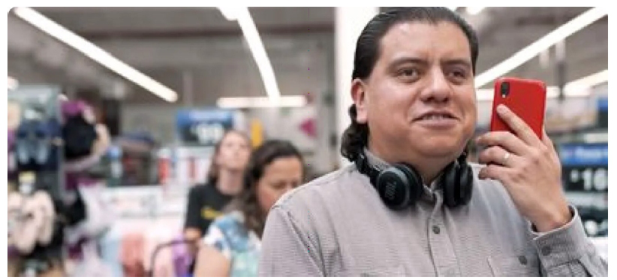
Figure 2: GoodMaps users can scan a supported environment with a phone’s camera, which sends images to the GoodMaps machine learning system. GoodMaps uses these images to accurately pinpoint where the user is located within a building.
All aspects of the GoodMaps user experience are regularly tested as part of an iterative design and development process. Key features have been repeatedly tested and improved upon throughout the ongoing design and development process, including: the app’s interface and design, the process by which the app find’s a user’s location within a building, the routing experience from one location to another within a building, app directory and destination search, screen reader compatibility, notifications, verbosity, haptic and tonal feedback, and first-time user experience tutorials.
A typical UAT includes a one-on-one, user experience session in which a moderator guides a participant through a series of tasks that allows users to experience all aspects of the app interface and routing experience. Participants are first asked to download and launch the GoodMaps app, walking through a series of screens that include acknowledgements, permissions, and tutorials. Next, participants are asked to explore the app interface, which includes a visual map for sighted users and a building directory that can be explored visually or by using Apple’s screen reader or Android’s talkback feature for users who are blind or visually impaired. After a participant has fully acclimated to the app interface, they are asked to complete three to five routing tasks that allow them to use the GoodMaps app to travel to several pre-determined destinations in a building. In between each task, participants are asked to rate their level of agreement with several Likert-item statements intended to assess their perceptions of app usability and their ability to effectively and efficiently complete each task. Each session lasts 90 minutes to two hours and is followed by a brief follow-up interview to assess users’ perceptions of the overall user experience. This qualitative and quantitative feedback has directly contributed to iterative development
of the app, including the integration of new AI features to make the app more robust and the user experience more satisfying.
The following sections provide an additional audit of the ways in which AI contributes to GoodMaps functionality.
Computer Vision Computer vision is a function of AI that allows computers to recognize and interpret visual information.It uses machine learning to process images and videos and perform tasks like object recognition, which is a critical affordance for effective indoor navigation. GoodMaps’ computer vision technology interprets real-time data from a device’s camera and sensors, effectively guiding users through the environment, even without visual sightlines.
When GoodMaps scans a building, it collects a dense dataset of 360-degree imagery. This imagery is trained to detect unique details about the environment that can later be cross-referenced with images taken on a user’s camera. This results in an extremely accurate and fast “blue dot” position. In practice, this means that a GoodMaps app user can scan a supported environment with their smartphone’s camera, which sends images to the GoodMaps machine learning service. Within seconds, GoodMaps can use these images to pinpoint exactly where the user is within a building, with an accuracy of up to 25 centimeters. This accuracy not only enables a level of detail for indoor navigation that has never been possible, but it is also an inherent requirement to help blind and low-vision users navigate with the precision they need. It is worth noting, as well, that GoodMaps does not store any identifying information of app users or people who may be in the environment when someone is using the app to navigate.
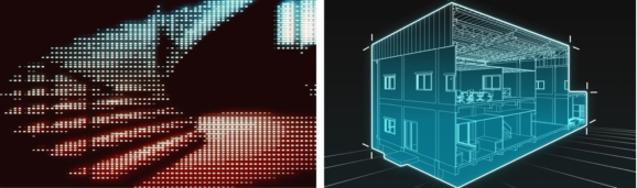
Figure 3: GoodMaps uses AI to process LiDAR scans and camera images to create 3D models of indoor spaces, including room layouts, hallways, and obstacles.
Indoor Mapping GoodMaps implements AI primarily to analyze visual data captured by LiDAR scanners and cameras. This allows technicians to accurately map complex indoor spaces and the app to provide precise navigation instructions by comparing real-time camera input to its pre-built 3D model. As a result, the app is able to effectively guide users through unfamiliar buildings with features like wayfinding and accessibility recommendations, all powered by machine learning algorithms. AI is used to process LiDAR scans and camera images to create detailed 3D models of indoor environments, including room layouts, hallways, and obstacles.
100 Palilonis and Meredith
AI algorithms can also calculate the best route based on user location, destination, accessibility needs, and potential obstacles. AI-powered mapping enables precise navigation, even in complex indoor spaces with many turns and similar-looking corridors. AI can assist visually impaired users by providing detailed verbal navigation instructions and by highlighting important landmarks.
Finally, AI can simplify the process of standardizing diverse data sources, enabling automated updates to indoor maps. For instance, many transit providers maintain proprietary elevator outage feeds. However, the lack of a unified standard for such data often necessitates repetitive and time- consuming integration work. By using a large language model (LLM) like ChatGPT, these feeds can be processed into structured, standardized formats that seamlessly integrate with mapping systems. This approach is particularly valuable as the complexity of managing the many data layers required for maintaining indoor environments continues to increase.
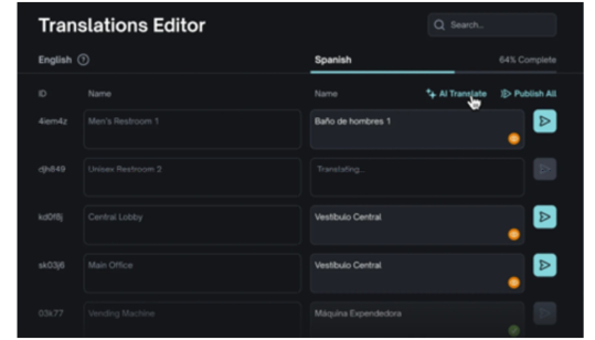
AI-Driven Language Translation GoodMaps also employs AI-powered language translators that use machine learning algorithms to translate text, speech, and images. Using the latest large language models like ChatGPT and Gemini, GoodMaps can quickly translate map destinations, descriptions, and other metadata at scale. At the click of a button in GoodMaps Studio (Figure 4), GoodMaps building owners can trigger all their map information to be translated. Then, after building owners review the translations for quality control and publish to the GoodMaps platform, visitors can experience the app and therefore the building itself in their native languages. This allows building owners to enable access to a wider audience than previously possible. This is particularly powerful, for example, in transit environments where people of all languages need access to signage delivered in the local language, or in museum environments where the idea of placing exhibit signage in dozens of different languages is unrealistic. In 2025, GoodMaps supports nine languages, with several more slated for future implementation.
Figure 4: Using GoodMaps Studio–the application used to manage an organization’s maps–building owners can make real-time changes to destinations, including AI-assisted language translations for in-app content.
As AI matures, new applications for mapping and navigation assistance will continue to evolve. In the future, AI will be used to tailor navigation instructions based on user preferences and accessibility requirements. The potential for real-time data integration will improve, incorporation of augmented reality will allow for enhanced interactive and informative experiences, and the devices end users apply to navigate indoor spaces will become less cumbersome (for example, with wearables) (WPGM Team, 2024). Likewise, “machine learning algorithms will allow maps to become highly personalized tools. With generative AI’s ability to learn from individual user behavior, it’ll be able to suggest routes, points of interest, and travel times indoor and out. … AI will also be used to predict future states of the map based on past data. These details include predicting potential traffic hotspots and environmental changes” (WPGM Team, 20204, para. 12–13).
As we look to the future, one of the particularly challenging aspects of mapping and navigating indoor environments is maintaining their dynamic nature. Chairs can be moved, escalators can break down, and wet floor signs can appear from seemingly nowhere, not to mention the impact of disruptive construction or other renovation. When existing data feeds are not available for detecting these changes–as in the elevator outage example previously discussed–the power of computer vision and large language models could empower mapping providers like GoodMaps to automatically detect these changes via the camera feed and flag them for building owners. Going a step further, the AI could automatically take action to update the map in order to accommodate blind and low-vision users who would be particularly impacted by these obstacles. In this scenario, AI becomes the air traffic controller of indoor environments, collecting and sending each new piece of information to the respective user, building owner, or component of the GoodMaps platform. By way of example, this vision would allow airport security line information to be crowd-sourced via AI, automatically rerouting through the quickest path. This type of advancement has the potential to not only make travel safer and more efficient for all users, but it could also be life-changing for individuals with vision or mobility disabilities that make independent indoor navigation challenging at best and impossible at worst.
REFERENCES
Berkovich, G. (2024, October 31). New road reporting features coming to Waze. Waze Blog.https://blog.google/waze/conversational-reporting-waze/#: ∼: text=All%20you%20need%20to%20do, to%20use%20a%20specific%20voice Daniel, M. (2024, October 31). New in Maps: Inspiration curated with Gemini,
enhanced navigation and more. The Keyword. https://blog.google/products/map s/gemini-google-maps-navigation-updates/ Guinness, H. (2024). What are AI hallucinations and how do you prevent them?
Zapier. https://zapier.com/blog/ai-hallucinations/ Hagendorff, T., & Wezel, K. (2020). 15 challenges for AI: or what AI (currently) can’t do. Ai & Society, 35(2), 355–365.
102 Palilonis and Meredith
Hasan, A. M., Samsudin, K., Ramli, A. R., Azmir, R. S., & Ismaeel, S. A. (2009). A review of navigation systems (integration and algorithms). Australian journal of basic and applied sciences, 3(2), 943–959. Lau, J. (2020). Google Maps 101: How AI helps predict traffic and determine routes.
The Keyword. https://blog.google/products/maps/google-maps-101-how-ai-helps -predict-traffic-and-determine-routes/ Liedtke, M. (2024, October 31). Google adds Gemini AI to its Maps, Waze apps.
Associated Press. https://www.nbcbayarea.com/news/tech/google-maps-waze-ge mini-ai/3695839/ Liedtke, M. (2024, October 31). Google Maps introduces features to help users explore and navigate. Associated Press. Liedtke, M. (2024, October 31). Google adds Gemini AI to its Maps, Waze apps.
Associated Press. https://www.nbcbayarea.com/news/tech/google-maps-waze-ge mini-ai/3695839/ Nasserddine, G., & Amal, A. (2023). Artificial intelligence in navigation systems. In Handbook of Research on AI Methods and Applications in Computer Engineering (pp.86–107). IGI Global. Palilonis, J. (2024). GoodMaps: Assessing an indoor navigation app built on camera-based positioning. In: Tareq Ahram, Luca Casarotto and Pietro Costa (eds) Human Interaction and Emerging Technologies (IHIET 2024). AHFE (2024) International Conference. AHFE Open Access, vol -1. AHFE International, USA. Palilonis, J., Cambron, C., & Hakim, M. (2023). Challenges, Tensions, and
Opportunities in Designing App-Based Orientation and Mobility Tools for Blind and Visually Impaired Students. In International Conference on Human- Computer Interaction (pp.372–391). Cham: Springer Nature Switzerland. Singh, P. (2024). Google Maps AI: 6 features that you must know in 2025.
Analytics Vidhya. https://www.analyticsvidhya.com/blog/2024/03/google-maps- ai-features-that-you-must-know/#: ∼: text=Smarter%20Route%20Planning: %20By%20analyzing, %2C%20audio%20guidance%2C%20and%20more Team digitaldefynd. (2025). 20 ways Apple uses artificial intelligence. Digitaldefynd. https://digitaldefynd.com/IQ/ways-apple-uses-ai/#:∼:text= Apple%20Maps%20leverages%20AI%20to,needs%20and%20provides% 20personalized%20guidance Team, G., Anil, R., Borgeaud, S., Alayrac, J. B., Yu, J., Soricut, R.,... & Blanco, L.
(2023). Gemini: a family of highly capable multimodal models. arXiv preprint arXiv:2312.11805. WPGM Team. (20204). The future of digital maps: 12 predictions for the next decade. WP Go Maps. https://www.wpgmaps.com/the-future-of-digital-maps -12-predictions-for-the-next-decade/ Zhang, Q., Kang, Y., & Roth, R. (2023). The ethics of AI-generated maps:
DALL· E 2 and AI’s implications for cartography (Short Paper). In 12th International Conference on Geographic Information Science (GIScience 2023). Schloss-Dagstuhl-Leibniz Zentrum für Informatik. Zhuang, Y., Sun, X., Li, Y., Huai, J., Hua, L., Yang, X.,... & Chen, R. (2023).
Multi-sensor integrated navigation/positioning systems using data fusion: From analytics-based to learning-based approaches. Information Fusion, 95, 62–90.
LISTED IN THE AHFE DIGITAL BOOKSTORE CATALOGUE
Explore the complete digital volume
Human Interaction and Emerging Technologies (IHIET-AI 2025): Artificial Intelligence and Future Applications
Read this individual research paper free through the original publisher, or explore the full digital proceedings book.
ISBN 978-1-964867-37-3
Explore this ISBN in the AHFE Bookstore ↗Listed in the July 2026 bookstore catalogue; search by ISBN to confirm current availability · Digital book purchase optional