Nowadays, wireless technologies are increasingly being used for human needs. Increasingly, technologies are emerging that are used by people not only for the need to transfer data. One of these technologies is the Internet of Things, which often uses wireless sensors with ZigBee data transmission technology as end devices.There are areas that require deployment of these networks on the territory, a large number of sensors are required, which must with sufficient accuracy “know” their position on the deployment area. Usually, devices with built-in GPS modules are used for this, but devices containing this module are significantly more expensive than without it. And if in a large distributed network with many segments, more than 1000 such devices are required, then a device with a GPS module can only be at most one for each segment. Therefore, if this is a forest where there are many thousands of trees and it is necessary to monitor fires at the initial stage, which take place in many US states in the summer, then the cognitive task of teaching those devices, that do not contain a GPS module, to determine their position is relevant. This paper proposes a mathematical formulation of the cognitive task of learning to determine the coordinates of devices in wireless sensor networks. The study of the mathematical model has been carried out. The purpose of these studies was to find new alternative teaching methods for determining the distance between objects of IoT sensor networks, using the function of localizing objects where an emergency occurred.
Nowadays, wireless technologies are increasingly used in cognitive informa- tion systems. This article will describe the concept of using wireless sensor networks (WSN) as a cognitive computing system of monitoring the para- meters of protected objects, namely the distance (the location of objects). Wireless sensor networks consist of a large number of sensor nodes that are used to control a specific area. This type of network, which uses the ZigBee standard, has become popular due to its application, which includes several
areas, such as the environmental, medical, industrial, household, agricultural, and meteorological ones. The main areas of application are protected objects, such as forests (where one needs to monitor a large number of trees), wareh- ouses, stores, exhibitions and expositions, where it is important to control the movement of valuables in a limited area with a large concentration of peo- ple (the article examines the area of 250x250 meters, which corresponds to an average warehouse, hypermarket or exhibition hall, or an average forest area). It can be used at hospitals not only to measure temperature, pressure and other vital signs, but also to monitor the movement of patients, if neces- sary. For objects that are situated for a long time in a certain area, they can be manufactured on a solid printed circuit board, but for the cases described above, a flexible and thin plastic base is provided, which significantly redu- ces their cost and expands the scope of application. Today, “wireless sensor networks” (hereinafter referred to as sensor networks) are gaining more and more attention around the world.
The concept of “sensor network” appeared relatively recently (several years ago), but today it is already a completely stable term, which denotes a distributed cognitive IoT system, a self-organizing one, consisting of many simple miniature devices (nodes), each of which contains a microcontroller, a receiver and a stand-alone power supply. Nodes are equipped with sensors capable of recording information about the parameters of physical fields of different nature in their locations (Fig. 1). In the normal state, ZigBee netw- ork sensor modules are in a semi-active position. In this state, each of them only monitors its position relative to neighboring modules. But when, com- pared to the previous value, the distance to at least one of the “neighbors” changes, the network goes into active mode. In this state, there is a constant exchange of information about the location of each of the network modules, and the computerized cognitive IoT control system, which includes the sensor network, performs certain control actions.
ANALYSIS OF RECENT RESEARCH A number of works of modern scientists are devoted to issues of the research of IoT cognitive technologies based on wireless sensor networks including the research of technologies of modeling, control and interaction in monitoring the parameters of a system (including the distance between objects) – works devoted to measuring distance using wireless sensor networks (Akyildiz et al., 2002; Boukerche et al., 2007, 2008; Brooks et al., 2004; Hofmann- Wellenhof et al., 2012; Intanagonwiwat et al., 2000; Niculescu and Nath, 2003; Priyantha et al., 2001). In (Akyildiz et al., 2002), a general overview of the existing technologies of sensor networks is carried out, and only their shortcomings are analyzed. In Boukerche et al. (2007, 2008), localization algorithms are considered that can improve the process of measuring the distance between objects. In Brooks et al. (2004) and Hofmann-Wellenhof et al. (2012), the existing problems of the integration of sensor networks and ways to solve them are considered. Inta- nagonwiwat et al. (2000), Niculescu and Nath (2003), and Priyantha et al. (2001) deal with localization methods used by satellite navigation systems, in
Cognitive Positioning Technologies for IoT Network Devices 129
Table 1. Dependence of localization error (1d) on the distance between adjacent modules (d) and signal arrival determination time error (1Treply).
Table available in the original PDF paper.
Equations and mathematical formulas are available in the original paper PDF.
particular, (Priyantha et al., 2001) also deals with energy-saving technologies for sensor networks.
At the same time, the problems of developing cognitive algorithms for localization of objects of wireless IoT sensor networks, as well as simula- tion modeling of the process of localization of objects in a forest area, using one or another localization algorithm to compare real positions of the objects and those obtained in the process of localization. In the future, this will help to analyze the advantages and disadvantages of localization algorithms and help to choose the most optimal one for a given situation.
The Purpose of the Paper To consider a sensory network as a kind of a cognitive IoT computing system, using the example of measuring the distance between objects. It is proposed to describe a mathematical formulation of this problem, in order to model the process of determining the distance between objects, based on the square constraint algorithm.
FORMULATION OF THE PROBLEM In simulation, wireless XBee sensor modules of the S2 S2C ZigBee series will be used in this work. According to the technical documentation and the standard (IEEE Standard for Low-Rate Wireless Networks, 2019; Trush et al., 2021), they have localization errors, which are shown in Table 1.
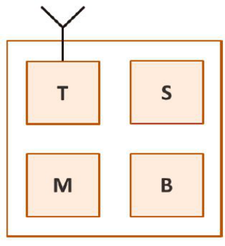
The appearance and block diagram of an XBee sensor module of the S2 S2C ZigBee series are shown in Fig. 1.
The following tasks are solved in the work:
Analysis of the structural scheme of a wireless sensor node and (con- struction) mathematical formulation of the problem of determining the coordinates of the nodes of an IoT cognitive sensor network;
Experimental study of the proposed mathematical formulation of the problem of localization of objects in a forest area of 250x250 m.
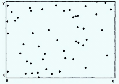
Figure 1: The appearance of the sensor module a), the structure of the sensor module b): T – radiofrequency transceiver; M – microcontroller; B – power supply; S – sensor.Figure 2: Scheme of the location of nodes of WSN spaces.
RESEARCH METHODS Measurement data is transmitted sequentially between nodes to the central server, for calculations by the IoT cognitive computing system and decision making (due to limited energy characteristics of autonomous batteries (B), measurement data from some nodes may be lost) (Boukerche et al., 2008).
A mathematical formulation of the problem of determining the coordinates in an IoT cognitive sensor network will be as follows. Suppose that in some region of space S of size S = AxB, the objects of an IoT cognitive wireless sensor network {i} are randomly distributed, where i = [1… M] (Fig. 2).
Each node (Figure 1) contains a transceiver (T), through which it can transmit the measurement results of the sensor (S) at a distance d to the neigh- boring nodes (the nodes in the radius L); based on this (based on the method
Cognitive Positioning Technologies for IoT Network Devices 131
Figure 3: Scheme of the location of nodes of WSN spaces.
of determining distances), the accuracy of the measurements conducted beco- mes known. Each node i accumulates information from all neighboring nodes j and writes it to a table in the memory of the microcontroller (M),
where J is the number of neighboring nodes; dij is the measured distance between nodes i and j.
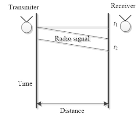
The measurement is carried out on the principle of determining the coor- dinates based on the time of signal arriving. In this case, the distance between the two nodes is directly proportional to the time when the signal propagates from one point to another. The information component of the signal sent con- tains the time of sending. This distance is measured on the basis of the time of sending the signal t1 and the time of its reaching the receiver node t2; the distance between the sender and the receiver is determined by the formula:
where sr is the propagation speed of the radio signal (the speed of light), and t1 and t2 are the times when the signal was sent and received (Fig. 3).
Based on this data, one needs to determine the coordinates of objects. In other words, one needs to solve the system of equations
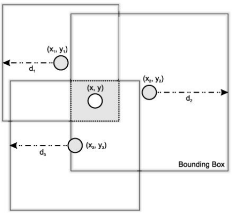
To solve the problem of localization, the Bounding Box method is propo- sed. An example of this method is shown in Figure 4 (Dudnik et al., 2020a; 2020b; Hu et al., 2019).
Figure 4: The Bounding Box method.
Assuming that the most probable node location is the central point among all reference nodes, we can calculate the position of an unknown node with- out the need to estimate distances or angles, but only when using a method based on signal range.
For each i-th reference node, a bounding square is defined as a square centered at the position of this node (xi, yi), with sides of size 2di (where d is the distance measured), with the coordinates (Prystavka et al., 2021; Burinska et al., 2006; Leshchenko et al., 2021):
xi −di, yi −di
and (xi + di, yi + di).
The intersection of all bounding squares can be calculated without the need for floating-point calculations; taking the lowest and the minimally high coordinates of all bounding squares:
max
, max
xi −di
yi −di
and
min
xi + di), min(yi + di
We obtain a shaded rectangle, which can be seen in Figure 4. The position of an unknown node is then calculated as the center of the intersection of all bounding squares (Zinovieva et al., 2021; Shytyk and Akimova, 2020; Iatsyshyn et al., 2020): !
max
+ min
+ min
xi −di
xi + di
yi −di
yi + di
bx,by
2 , max
This method is the simplest in terms of computing resources and infor- mation required. Only floating point operations (where n is the number of
Cognitive Positioning Technologies for IoT Network Devices 133
reference nodes) are required to calculate the position. The main thing is that the number of reference nodes is small, which is due to the fact that they, unlike simple nodes, contain built-in GPS-modules, which receive their coordinates based on satellite data, which for simple nodes are considered primary, on which they rely in the further process of localization.
The presence of more of these modules, although increases the accuracy of localization, but also makes such a network much more expensive, which reduces the economic effect of using such a system. Therefore, it is more cost-effective to find optimal algorithms for determining distance than buying additional reference nodes.
EXPERIMENT DESCRIPTION Based on the described mathematical model, in the MATLAB system, a model of a sensor network M with the number of nodes i = 200 was constructed (we obtain M = [1… 200]). The number of reference nodes was 10% (B = 20). The distance to each neighboring node (from i to j) dij = 35 m is a fixed tran- smission radius (dij is the measured distance from node i to the neighboring node j, as defined above).
The fixed transmission radius and the measured distance from node i to the neighboring node j are apparently different. When modeling in the MATLAB system, the nodes on the coordinate plane were distributed according to the uniform distribution law.
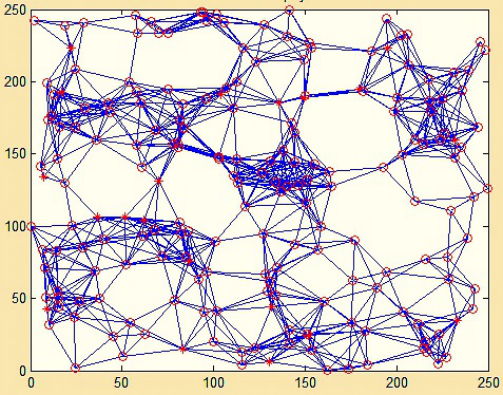
Then, the distance from the reference nodes, the position of which is known, to the neighboring ones is calculated, as well as their approximate coordinates. Then, according to the topology (Fig. 5), this information is sent to the neighboring nodes, where it is taken into account to determine, in turn, their position. In this case, the accuracy of the location of a node depends on the number of reference nodes next to it, as well as its distance from the neighboring nodes.
Therefore, the results of the localization of a node neighboring a reference one will be much more accurate than those for a node the path to which from a reference node contains several intermediate ones.
Analysis of the Research Findings
Figure 5 shows a localized network, in the form of an ordered topology, and identifies all nodes within the range of action.
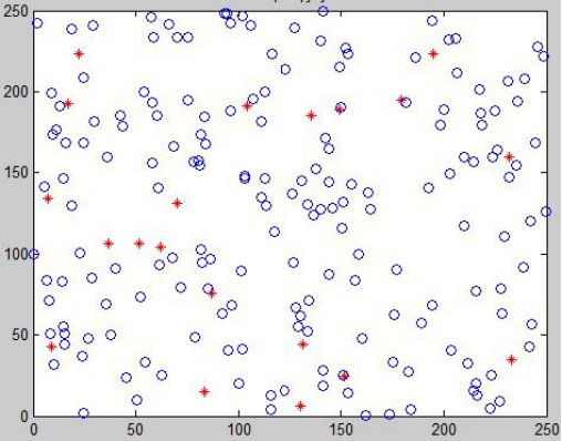
Figure 6 shows the location of 200 nodes, the positions of which are gene- rated randomly. A sign similar to “*” shows the reference nodes of the sensor network.
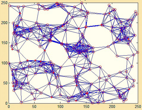
Figure 7 shows the difference in determining the coordinates of the location of nodes in the form of the distance between circles (the location of a node after localization) and the ends of lines (the actual location of the node). This is best seen when comparing Figures 6 and 7.
When modeling, using an algorithm in the built-in MATLAB language, a mathematical model of the bounding box algorithm described above is pro- grammed. The simulation of the process of distance determining is conducted based on the signal arriving time. The signal arriving time is modeled relative
Figure 5: The topology of the sensor network of a forest area of 250×250 m.Figure 6: Nodes location.
to the actual distance between the nodes, the location of which was determi- ned on the basis of the uniform distribution law. Also, by the signal arriving time, depending on the distance between the nodes, one of the four errors (1Treply) is arbitrarily included (Table 1). Further research is planned to obtain theoretical estimates of measurement errors by different methods, to conduct experiments with this model, increasing the number of nodes, as well as using different algorithms for determining the distance between nodes, to estimate the localization error when using each of them.
Cognitive Positioning Technologies for IoT Network Devices 135
Figure 7: Comparing real positions of nodes (marked with lines) and the results of localization (marked with circles).
CONCLUSION
The use of IoT cognitive systems based on wireless sensor networks has been further developed as a method of measuring the parameters of objects, which improves the localization process, with a maximum error of determining coordinates 1d = 10 meters, which is quite small in localizing forest fires. A mathematical formulation of the problem of determining the coordinates in a sensor network, which is part of an IoT cognitive computer system, is propo- sed, which is more cost-effective for determining distance than the purchase of additional reference nodes. The tasks of further research are determined.
REFERENCES
Akyildiz, I. F., Su, W., Sankarasubramaniam, Y., & Cayirci, E. (2002). Wireless sensor networks: a survey. Computer networks, 38(4), 393–422. Boukerche, A., de Oliveira, H. A., Nakamura, E. F., & Loureiro, A. A. (2007, July).
Towards an integrated solution for node localization and data routing in sensor networks. In 2007 12th IEEE Symposium on Computers and Communications (pp. 449–454). Boukerche, A., Oliveira, H. A., Nakamura, E. F., & Loureiro, A. A. F. (2008, May).
A novel location-free greedy forward algorithm for wireless sensor networks. In 2008 IEEE International Conference on Communications (pp. 2096–2101). Brooks, R. R., Zhu, M., Lamb, J., & Iyengar, S. S. (2004). Aspect-oriented design of sensor networks. Journal of Parallel and Distributed Computing, 64(7), 853–865. Burinska, Z., Runovski, K., & Schmeisser, H. -. (2006). On the Approximation by
Generalized Sampling Series in lp - Metrics. [J] Sampling Theory in Signal and Image Processing, 5(1), 59–87. Dudnik, A., Kuzmych, L., Trush, O., Domkiv, T., Leshchenko, O., & Vyshnivskyi, V. (2020a, October). Smart Home Technology Network Construction Method and Device Interaction organization Concept. In 2020 IEEE 2nd International Conference on System Analysis & Intelligent Computing (SAIC) (pp. 1–6). IEEE.
Dudnik, A., Kvasnikov, V., Trush, O., & Domkiv, T. (2020b). Development of distributed Multi-Segment Wireless Networks for Determining External Situtions. In IT&I Workshops (pp. 127–137). Hofmann-Wellenhof, B., Lichtenegger, H., & Collins, J. (2012). Global positioning
system: theory and practice. Springer Science & Business Media. Hu, Z., Liskin, V., Syrota, S., Cholyshkina, O., & Seilova, N. (2019). Ontology- Based Model of Information Technology for E-Learning Systems. In COAPSN (pp. 230–241). Iatsyshyn, A. V., Kovach, V. O., Lyubchak, V. O., Zuban, Y. O., Piven, A. G.,
Sokolyuk, O. M., Shyshkina, M. P. (2020). Application of Augmented Reality Technologies for Education Projects Preparation. Paper presented at the CEUR Workshop Proceedings, , 2643134–160. “IEEE Standard for Low-Rate Wireless Networks - Amendment 7: Defining Enhancements to the Smart Utility Network (SUN) Physical Layers (PHYs) Supporting up to 2.4 Mb/s Data Rates,” in IEEE Std 802.15.4x-2019 (Amendment to IEEE 802.15. 4–2015 as amended by IEEE 802.15.4n-2016, IEEE 802.15.4q-2016, IEEE 802.15.4u-2016, IEEE 802.15.4t-2017, IEEE 802.15.4v-2017, IEEE 802.15.4s-2018, and IEEE 802.15. 4–2015/Cor. 1-2018) , vol., no., pp. 1–30, 26 April 2019, doi: 10.1109/IEEESTD.2019.8700703. Intanagonwiwat, C., Govindan, R., & Estrin, D. (2000, August). Directed diffu-
sion: A scalable and robust communication paradigm for sensor networks. In Proceedings of the 6th annual international conference on Mobile computing and networking (pp. 56–67). Leshchenko, M. P., Kolomiiets, A. M., Iatsyshyn, A. V., Kovalenko, V. V., Dakal, A. V., & Radchenko, O. O. (2021). Development of Informational and Research Competence of Postgraduate and Doctoral Students in Conditions of Digital Tran- sformation of Science and Education. Paper Presented at the Journal of Physics: Conference Series, , 1840(1) doi: 10.1088/1742-6596/1840/1/012057 Retrieved from www.scopus.com Niculescu, D., & Nath, B. (2003, March). Ad hoc positioning system (APS) using
AOA. In IEEE INFOCOM 2003. Twenty-second Annual Joint Conference of the IEEE Computer and Communications Societies (IEEE Cat. No. 03CH37428) (Vol. 3, pp. 1734–1743). Priyantha, N. B., Miu, A. K., Balakrishnan, H., & Teller, S. (2001, July). The cricket compass for context-aware mobile applications. In Proceedings of the 7th annual international conference on Mobile computing and networking (pp. 1–14). Prystavka, P., Dukhnovska, K., Kovtun, O., Leshchenko, O., Cholyshkina, O.,
& Zhultynska, A. (2021). Devising information technology for determining the redundant information content of a digital image. Eastern-European Journal of Enterprise Technologies, 6(2 (114), 59–70. https://doi.org/10.15587/2021. 248698 1729–4061. Shytyk, L., & Akimova, A. (2020). Ways of Transferring the Internal Speech of Characters: Psycholinguistic projection. Psycholinguistics, 27(2), 361–384. doi:10.31470/2309-1797-2020-27-2-361–384. Trush, O., Kravchenko, I., Trush, M., Pliushch, O., Dudnik, A., & Shmat, K. (2021,
December). Model of the Sensor Network Based on Unmanned Aerial Vehicle. In 2021 IEEE 3rd International Conference on Advanced Trends in Information Theory (ATIT) (pp. 138–143). Zinovieva, I. S., Artemchuk, V. O., Iatsyshyn, A. V., Popov, O. O., Kovach, V.
O., Iatsyshyn, A. V., Radchenko, O. V. (2021). The Use of Online Coding Platforms as Additional Distance Tools in Programming Education. Paper pre- sented at the Journal of Physics: Conference Series, , 1840(1) doi:10.1088/1742- 6596/1840/1/012029.
LISTED IN THE AHFE DIGITAL BOOKSTORE CATALOGUE
Explore the complete digital volume
Cognitive Computing and Internet of Things
Read this individual research paper free through the original publisher, or explore the full digital proceedings book.
ISBN 978-1-958651-19-3
Explore this ISBN in the AHFE Bookstore ↗Listed in the July 2026 bookstore catalogue; search by ISBN to confirm current availability · Digital book purchase optional